
| ICE Case Studies
|
Armenian Independence and Deforestation Diana Piloyan Boudjikanian |
I.
Case Background |

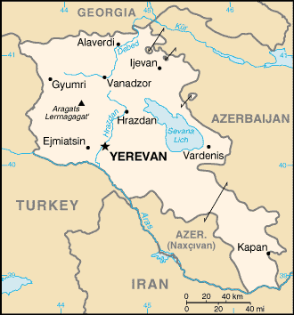
Source: United Nations Country at a Glance.
The Republic of Armenia faced several problems after gaining its independence from the Soviet Union. The energy crisis in the 1990s determined its future in many ways. One of its negative effects was the acceleration of the deforestation rate. This situation caused deforestation to become one of the main environmental problems in Armenia. Today, deforestation continues being considered a very serious ecological threat. According to the Armenia Tree Project, over 750,000 cubic meters of forest coverage are now being cut annually. At the current deforestation rate, Armenia faces the probability of turning into a barren desert within 50 years. The environmental consequences of deforestation are already causing many problems and they will get worse if measures are not taken to reduce the current deforestation rate. Land erosion and landslides will multiply and the soil will lose all of its agricultural properties. (ATP) The Armenian people have depended on the forests to endure the energy crisis. Now they need to develop and use alternative energy sources, to protect and preserve their forests.
Independence
In January 1991, the Armenian Supreme Soviet decided not to participate in President Gorbachev's planned referendum on preserving the Soviet Union. Instead, they would hold their own referendum (in compliance with the procedure outlined in the Soviet Constitution for a Soviet Republic to secede). In August 1991, when the attempt to overthrow President Gorbachev took place in Moscow, the Armenian armed forces were mobilized. The Moscow coup convinced Armenians that it was time to separate from the Soviet Union. On September 21, 1991 the people of Soviet Armenia organized a referendum to secede from the Soviet Union and declare independence. The referendum had a participation of 94% and was approved by 99% of the population. The independence of the Republic of Armenia was formally declared on September 23, 1991 and a new Constitution was adopted in July 1995. Now that Armenia was independent, it had to start rebuilding its devastated economy.
Deforestation
The armed conflict in Nagorno Karabagh since 1988, the energy blockade imposed by Azerbaijan at the end of 1991, and the 1992 war in Abkhazia (which closed the route to Russia through Georgia), were very difficult obstacles to overcome. By 1993, the Armenian government could not find a way to begin solving the social, economic, and political problems. The last remaining oil and gas pipelines through Georgia were blown up by saboteurs. To survive the cold winter, Armenians began cutting down the trees to use them as firewood. The energy crisis of the 1990s increased the deforestation rate in the country. Illegal wood cutting increased sharply because the people needed fuel to cook, for warmth, and to function economically. The trees provided an excellent source of fuel.
The Armenia Tree Project (ATP) was founded in 1994 to help Armenia's socioeconomic development, by mobilizing resources to fund greenery restoration and reforestation programs. ATP works to promote self-sufficiency, conserve Armenia's indigenous ecosystem, reverse the deforestation rate, restore the degraded and lost forest areas, improve the standard of living of the Armenian population, and protect the environment. Its first tree planting project started in the spring of 1994 at the Nork Senior Center. Since 1994, ATP has planted and restored over 531,000 trees in over 500 community sites from Gyumri to Goris. By 2006, its programs will have the capacity to produce and plant over one million trees per year. The final goal is to plant 15 million trees throughout Armenia by the year 2015. (ATP)
In 2005 the Armenian economy grew 10.2% in just six months, according to the Republic of Armenia Ministry of Trade and Economic Development. At the same time, the World Wildlife Fund and Conservation International reported that Armenia's environment has been on a downward spiral for the past 15 years. (ATP)
Today, only 10% of Armenia is covered with forests. The loss of hundreds of thousands of trees since the 1990s continues today. The trees are needed for commercial transactions and for the survival of rural residents, who have no alternative sources of fuel. Trees are essential for life. They provide shade, medicine, clean air, and fresh water. They are also fundamental for the existence of agricultural output, wildlife, and for fruit growing (which is an essential economic activity in Armenia). (ATP)
Source: University of Texas at Austin.
[This image is courtesy of the University of Texas Libraries, The University of Texas at Austin.]
Armenia (covering an area of 30,000 square kilometers) is a landlocked country in the southern Caucasus. It is located between the Black Sea and the Caspian Sea. Armenia is bordered on the north by Georgia, on the east by Azerbaijan, on the southwest by the Nakhichevan Autonomous Republic of Azerbaijan, on the south by Iran, and on the west by Turkey. Though geographically in Western Asia, politically and culturally Armenia is closely aligned with Europe. Therefore, Armenia is seen as a transcontinental nation.
Armenia is located in the north-east part of the Armenian Highland. The Armenian Highland (covering an area of about 400,000 square kilometers) is part of the Transcaucasian Highland and constitutes the continuation of the Caucasus mountains. It is a mixture of lava plateaus, volcanic cones, fault-fold ranges, and a number of lakes (Lake Sevan, Lake Van, and Lake Urmia) in tectonic depressions. Most of the Armenian Highland is in Turkey, with some part in Iran, Georgia, and Azerbaijan.
The highest point of the Armenian Highland is Mount Ararat (5,165 meters). It is located in the far northeast part of Turkey and it dominates the skyline of Yerevan (Armenia's capital). In earlier times, Mount Ararat was located in what is historically and geographically regarded as part of Armenia. However, following the Treaty of Kars in 1923, Turkey and the Soviet Union divided the land and established a new border between Turkey and Armenia, placing Mount Ararat on the Turkish side. The Book of Genesis in the Bible identifies this mountain range as the resting place of Noah's Ark after the Great Flood. "And on the seventeenth day of the seventh month the ark came to rest on the mountains of Ararat". (Genesis 8:4) Mount Ararat is considered as the Armenian national symbol.
The government and citizens of Armenia and the government and citizens of Azerbaijan.
After the separation from the Soviet Union and the pressure from the Azerbaijani energy blockade, environmental conditions in Armenia got worse. The winters of 1991-1992, 1992-1993, and 1993-1994 were specially hard for the population. With no other choice, they turned to the forests for fuel. That is why the Armenian deforestation rate began to accelerate in the 1990s. Estimations reveal that almost half of the energy consumed in households near forested areas came from fuel wood. (IFR)
Armenia's forests are subtropical (61%) and temperate (39%). (M) The Armenian forest cover contains 110 tree and 152 shrub species. It is divided into three regions: northeast, southeast, and central. According to the data on table 1, the northeast is the region with the most forest cover in the country (62%) and the central region is hardly covered by forests (2%).
Table 1: Armenian Forest Cover by Region
Region |
% |
Northeast |
62% |
Southeast |
36% |
Central |
2% |
TOTAL |
100% |
Source: "Evolution of the Forest Cover in Armenia".
In 1988 Armenia's forests were mostly covered with oak, beech, and hornbeam. These tree species represented 81.3% of the total forest cover. Pine, juniper, and coppice hornbeam covered 10.3% of the forests. The remaining 8.4% of forest cover included ash and elm, among other species. Table 2 shows the hectares and the individual percentages of each type of tree.
Table 2: Area and Percentage of Total Forest Cover in Armenia (1988)
Tree Species |
Area (hectares) |
Total Forest Cover, 1988 (%) |
Pine |
17,700 |
5.3% |
Juniper |
8,400 |
2.5% |
Oak |
120,000 |
35.9% |
Beech |
96,600 |
28.9% |
Hornbeam |
55,100 |
16.5% |
Coppice Hornbeam |
8,300 |
2.5% |
Elm |
3,006.9 |
0.9% |
Ash |
7,350.2 |
2.2% |
Other |
17,642.9 |
5.3% |
TOTAL |
334,100 |
100% |
Source: "Evolution of the Forest Cover in Armenia".
According to the forest inventory data shown on the previous table 334,100 hectares were covered by forest in 1988, representing approximately 11.2% of the Armenian territory. In 1988 there was practically no commercial forest cut and 90% of the demand for forest products was satisfied with imports from Russia. (IFR)
At the beginning of the 1990s the volume of the forests was 125 cubic meters per hectare (which represents half of the volume that is considered ecologically sound). (ATP)
Results from the 1998 Armenian Forest Resources Assessment Project show that legal and illegal cuttings started in 1991. During the 1991-1996 period, approximately 600,000 cubic meters were cut per year. (IFR)
Table 3 and graph 1 show the changes in forest cover through different periods of time. For instance, Armenia's forest cover decreased from 11.2% (1988) to about 10% (2005) of the national territory. (IFR)
Table 3: Armenian Forest Cover by Period
Period |
Forest Cover (hectares) |
Total Forest Cover (%) |
4,000 - 1 B.C. |
1,050,000 approx. |
35% |
1966 National Forest Inventory |
253,000 |
8.5% |
1978 National Forest Inventory |
296,600 |
9.98% |
1988 National Forest Inventory |
334,100 |
11.2% |
2005 |
283,000 |
10% |
Source: "Evolution of the Forest Cover in Armenia".
Graph 1: Armenian Forest Cover by Period
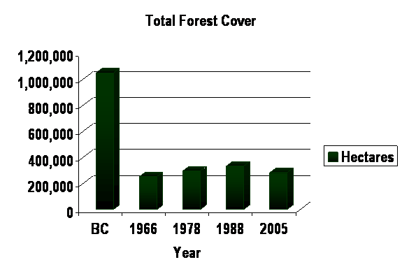
Source: "Evolution of the Forest Cover in Armenia".
By 2005 consumption of fuel wood had decreased from the 1990s level, due to the import of gas and electricity. However, it continues being used in towns and villages close to forested areas. People use the wood to produce construction materials (doors, windows, brandy barrels, and furniture) and as an export commodity to Europe, Turkey, and Iran. Unfortunately, the best trees are cut illegally. At the same time, grazing of livestock prevents regeneration and lack of education and sustainable forest management practices prevent reversing this current trend of over-cutting the forests. Armenia cuts and burns between 500,000 and 750,000 cubic meters of forest each year. (ATP)
In recognition of the important ecological and functional roles of forests, commercial clearance of forests has been banned. Selective logging is conducted for forest health and to encourage regeneration. However, illegal logging of forests is extensive. The continued deforestation process has many consequences. Some of these consequences are:
- Decline in productivity and in regeneration of forests.
- Air and water pollution.
- Changes in the microclimate and in the composition of species (populations of pest species has increased).
- Loss of habitat.
- Damage to infrastructure.
- Acceleration of desertification, leading to the abandonment of valuable and once fertile agricultural lands and to the creation of vast wasteland areas.
- Increase in erosion, causing floods, landslides, and mudflow (damaging regions like: Tavush, Sunik, and Lori).
Approximately 25% of the forest plantations have been cut at the Basin of Lake Sevan. Old high-quality mixed oak and beech forests are being replaced by young low-quality coppice hornbeam forests. (IFR)
In June 2005 the government announced plans to build a new highway in southern Armenia. This highway would pass right through the middle of the Shikahogh Nature Reserve. This highly unsustainable and environmentally damaging project planned to cut at least 14,000 old growth trees and 90,000 younger ones. Aside from the obvious deforestation problem, this would also threaten the habitat of several species of endangered animals and plants, attract illegal logging, and increase air pollution in the area. After public protest, the project seems to be postponed. For now, the Shikahogh and the Mtnadzor (ice-age forest that covers half of the reserve) have been spared. (ATP)
The mountain slopes around the northern city of Vanadzor (Armenia's third largest city) were once thickly covered with forests. Today, there are hardly any trees left. Because of logging, the ecological situation around Vanadzor is getting worse, even though the cut down rate is half of what it was in 1993. There is now increasing risk of landslides, the springs will dry up, biology is impoverished, and the topsoil is washed down from the hillsides, covering the roads after rainstorms. Until recently, the woodlands of the Lori, Vanadzor, and Tavush provinces made up two thirds of the forests in Armenia. However, a study from the Center of Ecological Research at the American University in Yerevan warns that if they continue cutting down the trees at the present rate, in 20 years there will be no woodlands left in Armenia. (LN)
Even though there is no available data for the present levels of forest cuts, some studies suggest that these cutting levels are higher than the most recent estimates of the average growth rate of the Armenian forests. (IFR)
If the current deforestation rate continues in Armenia, and an important reforestation program is not implemented soon, Armenia will have virtually no forests. This will cause Armenia to face another type of environmental crisis in the very near future: desertification and severe depletion of water sources. In other words, the country will be unable to support its population through agriculture. (ATP)
Table 4 shows that the change in the Armenian forest cover during the 1990-2005 period was almost 19% (approximately 63,000 hectares).
Table 4: Change in Forest Cover in Armenia (1990 - 2005)
| Forests in 1990 | 346,000 ha |
| Forests in 2000 | 305,000 ha |
| Forests in 2005 | 283,000 ha |
| Annual Change 1990-2000 (ha) | - 1.18% |
| Annual Change 2000-2005 (ha) | - 1.44% |
| Total Change 1990-2005 (ha) | - 18.21% |
Source: Mongabay.
Even though the economy has improved at a macroeconomic level, it will take several years for the deforestation and degradation processes to slow down. The Armenian people and the international community must take immediate action to protect the forest cover before it completely disappears.
Despite the harshness of winter in most parts, the fertility of the plateau's volcanic soil made Armenia one of the world's earliest sites of agricultural activity. Armenia's multiple agronomic zones are ideal for the cultivation of a wide range of crops and animal products. Its range of elevations and microclimates allow production of several varieties of grapes and tree fruits. The richest farmland is found on the Ararat plain in southwestern Armenia (irrigated by the Arax River) and in the valleys north of Yerevan.
Topography
The Lesser Caucasus range extends through northern Armenia, runs southeast between Lake Sevan (Armenia's largest lake, 376 kilometers long) and Azerbaijan, then passes roughly along the Armenian-Azerbaijani border to Iran. The mountains make travel from north to south very difficult. About half of Armenia's area of 29,800 square kilometers (of which 80% is mountainous) has an elevation of at least 2,000 meters; only 3% of the country lies below 650 meters. The lowest points (elevation 400 meters) are in the valleys of the Arax River and the Debet River in the north. Mount Aragats is the highest point in Armenia with an elevation of 4,430 meters. The valley of the Debet River and the Akstafa River form the main routes into Armenia from the north, as they pass through the mountains. Most of the population lives in the western and northwestern parts of the country, where the two major cities (Yerevan and Gyumri) are located. (EIU)
Climate
Armenia has a highland continental and dry climate, with cold winters and warm summers. Temperatures generally depend upon the elevation. Mountain formations block the moderating climatic influences of the Mediterranean Sea and the Black Sea, creating wide seasonal variations. On the Armenian Plateau, the average midwinter temperature is 0ºC (January is the coldest month) and the average midsummer temperature exceeds 25ºC (July is the warmest month). Average precipitation ranges from 250 millimeters per year in the lower Arax River Valley, to 800 millimeters at the highest altitudes. The heaviest rainfall is in the mountains.
While there are fertile areas, most of Armenia consists of uplands which are not suitable for cultivation. That is why Armenia depends almost entirely on imports of grain and meat products (60%), dairy products (65%), and energy supplies from the Soviet republics, mainly Russia and Turkmenistan. (EIU)
As a result of the blockade imposed by Azerbaijan on Armenia since 1989, the only route for supplies of grain, meat, oil, gas, and dairy products from Russia was through Georgia. Civil unrest from the end of 1991 and the war in Abkhazia have made this lifeline very insecure. In 1991 Azerbaijan closed down the main gas pipeline which transported Russian gas to Armenia. Additionally, the pipeline carrying gas to Armenia was repeatedly blown up right where it passed through the Marneuli region of Georgia, which is heavily populated by Azeris. So, it is not hard to see that the oil and gas supply situation became critical in Armenia at the beginning of the 1990s. The winters of 1991-1992, 1992-1993, and 1993-1994 brought enormous hardships to the Armenian population. Life was practically unbearable in winter. There was no hot water, heat, or electricity for domestic purposes. The population had no other feasible choice but to cut down the trees. Furniture and trees from the parks were being used as fuel for cooking and for heating. Between 1990 and 2005 Armenia lost approximately 19% of its forest cover and 15.7% of its forest and woodland habitat. (EIU)
In 1992 they reopened the bridge across the Arax River into Iran, which helped a little. Two years later, the blockade by Azerbaijan and Turkey continued and most industrial firms were operating at only 15% of capacity, because of lack of energy. A severe energy rationing program was enforced. Many apartments in Yerevan did not have heat during the winter. The inhabitants of Yerevan were restricted to one hour of electricity a day during the 1993-1994 winter. This situation motivated Armenia to work to strengthen its trade relations with Iran; even though an air corridor had been opened through Turkey. In 1995 Armenia signed agreements with Iran and Turkmenistan on issues related to transportation and energy, among others. That same year, the level of the energy crisis made the government reopen the 440-mw-capacity Medzamor Nuclear Power Plant, which was closed for safety reasons since 1988. This helped boost electricity generation and continues to do so until today. Back in 1995, Armenia signed a preliminary agreement with the European Union to close the power station within five years, because it was a serious safety risk. However, the Armenian government has not been able to close it because of lack of alternative electricity generating sources. Armenia is willing to close the facility if it can secure more financial support from the European Union and secure alternative energy supplies. (EIU)
The Armenian economy began showing signs of recovery during the second half of the 1990s. Trade with Iran and the linkage of the electricity grids has helped to keep Armenia afloat. With the imposition of the economic blockades by Azerbaijan and Turkey, the closure of the railway links between Abkhazia (Georgia) and Russia, and Armenia's goal to decrease its energy dependence with Russia, the Armenian government is seeking to diversify its sources of gas. Iran represents its most reliable overland trade route. In December 2001 it signed a preliminary agreement with Iran for the construction of a gas pipeline, through which Armenia would import gas from Turkmenistan. However, the project continues to be delayed, because Armenia has yet to secure external funding for the construction of the pipeline. There are also plans to connect the Armenian and Iranian road systems and to construct a hydroelectric generating plant on the Arax River. (EIU)
Georgia is still the only route to the Black Sea. Since Armenia is strongly dependent on that route, it keeps close relations with Georgia. Relations are stronger since the signing of the 2001 Bilateral Treaty of Friendship, Cooperation, and Mutual Security. However, they could come under strain if Georgia starts cooperating militarily with Turkey. (EIU)
Although Armenian culture was largely preserved under the Soviet rule, the boundaries of the Republic set by the Soviet Union were never fully accepted. Nagorno Karabagh was an independent state before 1921. In 1921 the Bureau of Caucasian Affairs declared the region part of Armenia. However, Stalin reversed the order and transferred Nagorno Karabagh to the jurisdiction of the Soviet Republic of Azerbaijan a few days later. Nagorno Karabagh became an autonomous region in 1923. The Armenians objected, since 80% of Nagorno Karabagh's population was Armenian. (EIU) They were also unhappy that Nakhichevan (with a substantial Armenian community) was given the status of an autonomous republic within Azerbaijan. In the 1930s the Turkish-Iranian border was adjusted, giving Turkey a border with Nakhichevan.
Once the policies of Perestroika and Glasnost took hold in the 1980s, demonstrations were held in Armenia to demand the incorporation of Nagorno Karabagh. The pressure for reunification was formally reinitiated in 1988, with the establishment on the Karabagh Committee. Moscow responded by sending 5,000 troops into the region and by imposing direct rule over it. The tension increased when ethnic Armenians in the Azerbaijani city of Sumgait were massacred.
In September 1989 Azerbaijan began an enormous blockade of Armenian vital fuel and food supply lines through its territory; which, in those days, carried about 90% of Armenian imports from the other Soviet Republics. A couple of months later, Armenia declared Nagorno Karabagh part of the Armenian proper. In 1990 the violence began again in Baku (capital of Azerbaijan). This caused refugees to escape to their country of ethnic origin. The Soviet leadership declared a state of emergency in Nagorno Karabagh and along the Armenian-Azerbaijani border. In 1991 the sporadic fighting intensified and both countries gained their independence from the Soviet Union. (EIU)
In 1992, as soon as the last Russian troops left Nagorno Karabagh, it declared its independence. Even though Armenia supplied troops, weapons, and money, it did not officially recognize its independence. In the meantime, the conflict between Armenia and Azerbaijan turned into a full-scale war. Both countries used heavy artillery, tanks, and air power. In 1993 Russia mediated a temporary cease-fire. The agreement was violated and the fighting continued. By the end of the year, Armenia had managed to expel Azerbaijani forces completely from Nagorno Karabagh, had established a land corridor to the region, had started to capture Azeri towns around the enclave to create a buffer zone, and had seized land to use as a bargaining chip in negotiations. Thousands of Azeris fled the Armenian advance, especially after Armenian troops massacred civilians at Khodjaly. By 1994, Armenia controlled one fifth of the Azerbaijani territory, including Nagorno Karabagh. In May of that year, both countries signed a Russian-mediated cease-fire. (EIU)
During the 1995-2003 period there were negotiations between both countries, but they were not able to reach an agreement. The economic and energy blockade continued causing problems in Armenia. In 2004, ten years after the beginning of the cease-fire, the situation between both countries was growing more tense and each side accused the other of violations to the agreement. During the first months of 2006 the foreign ministers of each country met and drafted a short preliminary document that outlined the principles for future action. Maybe this is the first step toward a final-status agreement.
The two conflicts that caused an increase in the deforestation rate in Armenia can be classified as military and armed conflicts. These conflicts are:
The level of conflict started as intrastate and ended as inter-state.
The approximate casualty count is equal to 6,160 Armenians and 24,270 Azeris.
Source: United Nations Country at a Glance.
In every war or armed conflict we find two types of casualties: military and civil (direct and indirect). The conflict between Armenia and Azerbaijan and the conflict between Armenia and the Soviet Union are not the exception.
In February 1988 Armenian deputies to the National Council of Nagorno Karabagh voted to unify that region with Armenia. Although Armenia did not formally respond, this act triggered an Azerbaijani massacre of more than 100 Armenians (32 Armenians officially) in the city of Sumgait, just north of Baku. A similar attack on Azeris occurred in the Armenian town of Spitak. (AK)
In November 1988 the entire population of 600 Armenian families was removed from Madrasa, a village outside Baku, Azerbaijan; and they dispersed throughout the Soviet Union. (AK)
Soviet troops marched into Baku and opened fire on civilians, killing 130 people (approximately 70 Azeris and 60 Armenians), according to official statistics. (RFE)
Armenian forces attacked the Azerbaijani populated village of Xocali, killing most of the population of several hundred. (RFE)
Emigration of 350,000 Armenians residing in Azerbaijan and over one million Azeris residing in Armenia or Nagorno Karabagh. (EIU)
In 1993 Armenians massacred civilians at Khodjaly. (EIU)
During the first years of the armed conflict (1988 - 1994) between Armenia and Azerbaijan, the casualties were approximately 30,000 soldiers. On the Armenian side 6,000 soldiers were lost and on the Azerbaijani side 24,000 soldiers died. In addition, one million people have been left homeless on both sides. (AP)
Table 5: Casualties
Armenia |
Azerbaijan |
|
| Killed | 6,160 |
24,270 |
| Removed | 600 |
600,000 |
| Emigrated | 350,000 |
1,000,000 |
TOTAL(approx.) |
356,760 |
1,624,270 |
* Calculations based on the available information.
Source: Radio Free Europe.
The political collapse of the Soviet Union, the independence of the Soviet Republics, and the Azerbaijani blockade, combined to create a catastrophic public health situation in Armenia. Between 1989 and 1991, tuberculosis, viral hepatitis, and cancer were among the lowest in the Soviet Republics. Likewise, rates of infant mortality (17.1 per 1,000 persons) and maternal mortality (34.6 per 1,000 persons), were among the lowest rates in the Soviet Union. However, this all changed largely because of the Azerbaijani blockade and additional stress caused by war casualties. By 1992 it was almost impossible to have access to basic items such as surgical gloves, syringes, and chlorine for water purification. In this escalating medical crisis, elderly people and newborns were particularly at risk. Healthy infants were dying in hospitals because of the cold and the lack of adequate equipment. (AP)
The link between the environmental problem "deforestation" and the conflict lived in Armenia at the beginning of the 1990s (Independence from the Soviet Union), can be classified as an indirect link.
The independence movement did not originate because the Armenian forests were being cut, burned, or depleted. Rather, this movement began as a response to the inevitable fact that the preservation of the Soviet Union was no longer feasible. The political, social, and economic reality proved that the Soviet Union was falling apart. The attempt to overthrow the government in August 1991, marked the moment in which Armenians saw the opportunity to separate and gain their independence.
The link between the environmental problem "deforestation" and the conflict between Armenia and Azerbaijan over the region of Nagorno Karabagh (1988 - 1994, armed conflict; 1994 - 2006, isolated incidents), can be classified as a direct link. The energy blockade imposed by Azerbaijan led Armenia to an energy crisis during several winters and their only source for heat were the trees.
Causal Diagram
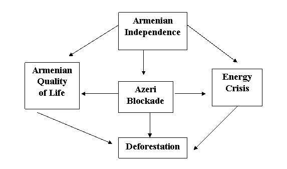
This diagram shows that the two major causes of Armenia's high deforestation rate during the 1990 - 2005 period are: the Armenian independence and the Azeri energy blockade. These two variables have a direct relationship with the deforestation variable. The independence and the blockade caused an energy crisis which, in turn, caused the deforestation. They also affected the Armenian quality of life in a negative way, leading to the deforestation.
The direct relationship between the Armenian independence, the energy crisis, and the deforestation problem can be described as follows. The newly independent Republic of Armenia had to organize its political, economic, and social structures. In addition, the country had to solve the problems caused by the energy blockade. Unfortunately, they did not have a lot of time to find solutions. It was the end of September and the bitterly cold winter was upon them. The population turned to the forests to find a way to solve their immediate needs. They cut down the trees and used the wood to cook and to warm themselves. That is why the deforestation rate increased during this period; and why it continues to be a very serious environmental problem.
The level of strategic interest is regional, since the deforestation is taking place in the Armenian territory. Among the sites that have suffered the most deforestation rate are: Vanadzor, Yerevan, the Teghut Forest, and the Gugark Forestry Zone, just to mention a few. (ATP)
The political part of the dispute with the Soviet Union was resolved on September 23, 1991, when the Armenian legislature declared Armenia's Independence. On the other hand, the military dispute with Azerbaijan was halted on May 12, 1994, when the cease-fire was negotiated. However, the environmental problem of deforestation in far from being resolved. Forests continue to disappear in Armenia at alarming rates.
Web sites
(AP) Armeniapedia - http://www.armeniapedia.org. On-line encyclopedia about Armenia.
(ATP) Armenia Tree Project - http://www.armeniatree.org. Organization that conducts environmental projects in Armenia's impoverished and deforested zones.
Armenian Diaspora - http://www.armeniandiaspora.com. The largest on-line Armenian news portal.
(AF) Armenian Forests NGO - http://www.armenianforests.am. Works to protect and restore Armenia's threatened forests, while helping to create jobs and build the economy.
Asbarez Armenian Online Daily Newspaper - http://www.asbarez.com
Caucasus Environment Outlook - http://www.gridtb.org. Regional report on the status of the environment in the Caucasus. It includes regional and environmental trends from Armenia, Azerbaijan, Georgia, and Russia.
Earth Trends - http://www.earthtrends.wri.org. Provides environmental information and data.
Institute of War and Peace Reporting - http://www.iwpr.net. Seeks to build peace and democracy through free and fair media in several regions of the world, including the Caucasus.
(LN) Lake Net- http://www.worldlakes.org. Global network working for the conservation and sustainable management of lakes.
Library of Congress Country Studies - http://lcweb2.loc.gov. Provides facts about a country.
(M) Mongabay - http://www.mongabay.com. Seeks to raise interest in the appreciation of wild lands while examining global trends in technology, economics, and finance on conservation and development.
(RFE) Radio Free Europe - http://www.rferl.org. Source of news and information from Europe, Russia, Caucasus, and Asia.
(UN) United Nations Country at a Glance - http://cyberschoolbus.un.org/information/index.asp?theme=fla&id=51
(UT) University of Texas at Austin- http://www.lib.utexas.edu/maps/armenia.html
Literature
(AK) Donabédian, Patrick; Lang, David Marshall; Walker J., Christopher; and Mutafian, Claude. Armenia and Karabagh: the Struggle for Unity. Minority Rights Publications, UK, 1991.
(IFR) Moreno-Sánchez, Rafael and Sayadyan, Hovik Y. "Evolution of the Forest Cover in Armenia". International Forestry Review, Vol. 7 (2), 2005.
(EIU) The Economist Intelligence Unit Country Profile: Armenia. The Economist Intelligence Unit Limited, UK, 1993-1994, 1994-1995, 1995-1996, 1996-1997, 1997-1998, 1998-1999, 1999-2000, 2001, and 2002.
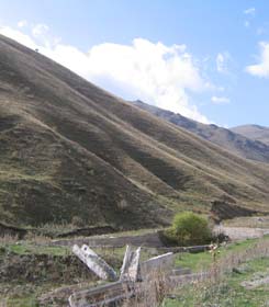
PHOTO GALLERY
I would like to thank Armenian Forests NGO and Armenia Tree Project for providing the photographs.
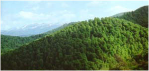
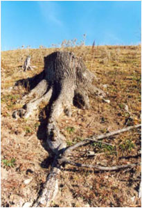
Courtesy of Armenian Forests NGO.
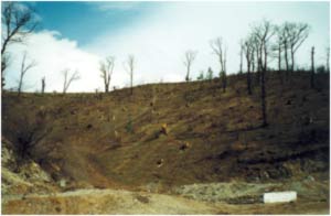
(VANADZOR)
Courtesy of Armenian Forests NGO.

Courtesy of Armenian Forests NGO.
Courtesy of Armenian Forests NGO.
Courtesy of Armenian Forests NGO.
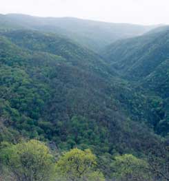
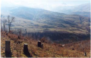
(SHIKAHOGH NATURE RESERVE)
Courtesy of Armenia Tree Project.
Courtesy of Armenia Tree Project.
© DPB, May, 2006.