
| ICE Case Studies
|
Arunachal Pradesh Territorial Dispute between India and China Yuki Kawaguchi |
I.
Case Background |
 I.
CASE BACKGROUND
I.
CASE BACKGROUND
1. Abstract
While some countries or states finish arguing their territories by now, there is one big territorial dispute between China and India. The region is called Arunachal Pradesh, which means “land of the dawn-lit mountains” or “land of rising sun.” Arunachal Pradesh is located in the northeast corner of the India and bordered on the north by the Tibet region of China and on the east by Myanmar. After Sino-Indian War in late 1962 ended, this territorial dispute also seemed to have ended. This region acquired an independent political status in January 20th, 1972, when it was declared as Union Territory, an administrative division of India ruled directly by the national government, under the name of Arunachal Pradesh. The state of Arunachal Pradesh Bill was passed by the Parliament in 1986 and with effect from February 20th, 1987; Arunachal Pradesh became the 24th state of Indian Union. Even though Arunachal Pradesh is administrated by India as a state, China still claims most of it as a part of the Tibet Autonomous Region.
2. Description
International law never supports a country or a state which attempts to plunder the territory from other countries or states by threatening or warfare. Article 2 of The UN Charter clearly defines that “all Members shall refrain in their international relations from the threat or use of force against the territorial integrity or political independence of any state” (Reynolds 2004.) It is so-called a territorial dispute, which is “a disagreement over the possession or control of land between two or more countries” (“Territorial Dispute.”) What leads the territorial dispute is not only relevant to the possession or control of natural resources such as oil, coals, fertile land or rivers, but also culture and religion. In addition, it has been said that “in many cases territorial disputes result from vague and unclear language in a treaty that set up the original boundary” (“Territorial Dispute”.) Consequently, many territorial disputes possibly generate some conflicts between countries, and even worse, they can become a primary cause of wars and/or terrorism.
A long time ago, before the territorial dispute between China and India emerged in Arunachal Pradesh, the first ancestors of the tribal groups migrated from Tibet during pre-historic period. Even though ancestors were there, little is known about the history of Arunachal Pradesh. Recorded history is only available in the Ahom chronicles from the sixteenth century: the British Christened, originally known as northeast Frontiers Agency (NEFA,) took administrative control of Arunachal Pradesh and it remained under this rule until 1948. Arunachal Pradesh is northeast India’s largest and remotest state, as it has railways and air services connecting only three of its town. Natives in Arunachal Pradesh used to eat “their food in uncooked condition ignorant about the discovery of fire” (WebDigitech.) They were really isolated and not aware of the development and revolution which was occurring in this globalized world.
The major cause of China-India territorial dispute, which deprived peace from Arunachal Pradesh, is from immediately after Chinese Revolution in 1911. At that time, Qing Dynasty, the last Chinese Dynasty, fell and the Emperor of Qing Dynasty resigned. As a result, China, Tibet and Mongolia became equal and separate countries. In these three countries, Tibet and Mongol tried to be approved internationally as independent states, and undertook to international society. However, on the other hand, Han Chinese Republicans started small war to subjugate reins of government of Tibet and Mongol. Therefore, they could not be independent states at that time.
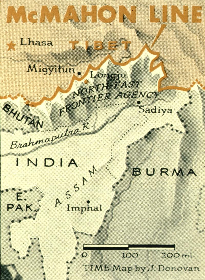 In
1912-13, the British Raj made agreements with tribal leaders that defined the
area that was known as NEFA. British rule could have very small impact on the
isolated, self-sufficient in terms of economy and militarily uncontrollable
tribal peoples. In order to arrange this conflict, in 1913 and 1914, the British
administrator, Sir Henry McMahon, drew up the 550-mile McMahon Line as the border
between India and China in Shimla, during a conference which also discussed
the Tibetan and Chinese borders (“McMahon Line.”) This conference
is called Shimla Conference. Regardless of this reconciliation, the McMahon
Line was rejected by the Chinese government in 1947 (“Arunachal Pradesh.”)
In
1912-13, the British Raj made agreements with tribal leaders that defined the
area that was known as NEFA. British rule could have very small impact on the
isolated, self-sufficient in terms of economy and militarily uncontrollable
tribal peoples. In order to arrange this conflict, in 1913 and 1914, the British
administrator, Sir Henry McMahon, drew up the 550-mile McMahon Line as the border
between India and China in Shimla, during a conference which also discussed
the Tibetan and Chinese borders (“McMahon Line.”) This conference
is called Shimla Conference. Regardless of this reconciliation, the McMahon
Line was rejected by the Chinese government in 1947 (“Arunachal Pradesh.”)
Following this dispute, the Chinese troops crossed the McMahon Line on the
August 26th, 1959 (“Arunachal Pradesh.”) They abandoned this in
1961, but in October 1962 crossed the line once again with force (“McMahon
Line.”) As a result, Sino-Indian War broke out. The Chinese extended their
frontier as they intruded deeper and deeper. However, this war did not go on
for a long time. In 1963, the Chinese agreed to withdraw back to the McMahon
Line, and also returned Indian prisoners of this war at that time.
3. Duration: 1 year
4. Location: Asia, South Asia, India
5. Actors: China and India
II.
Environment Aspects
6. Type of Environmental Problem: Territory
7. Type of Habitat: Cool
8. Act and Harm Sites:
| Site of Act | Site of Harm | Example |
| China | Arunachal Pradesh | Territory |
| India | Arunachal Pradesh | Territory |
By losing Arunachal Pradesh located on the northeastern tip of India, bordering Bhutan on the west, China on the north, Myanmar on the east and the states of Assam on the south, either China or India would receive some damage in terms of economy. Both China and India are able to run good business because Arunachal Pradesh is a very good place for tourists from all over the world to visit. Evergreen forest, which covers more than 60 percent of the state area, certainly makes people feel comfortable to stay there. From this fact, Arunachal Pradesh is known for its forest resources. Forest products and industries are considered as a lifeline in Arunachal Pradesh. In fact, 75 percent of its total workforce is engaged in agriculture (mainly shifting cultivation.) Therefore, if either China or India could obtain Arunachal Pradesh, it would be able to improve its economy by taking advantage of agriculture and tourism. In addition to it, there are many fairs and festivals there such as Losar, the New Year’s Celebration of the Monpas. Another famous festival there is called Reh, which is associated with the Idu Mishmis, the six-day celebrations’ special attraction is the Priest dance. Fairs or festivals are held every month, thus tourists can visit there any time for sightseeing.
III.
Conflict Aspects
9. Type of Conflict: War between China and India
10. Level of Conflict: Interstate
11. Fatality Level of Dispute (military and civilian fatalities): 4 (1,000 militaries and 1,000 civilians)
In 1962, the Chinese had a claim on what India deemed its own territory called Arunachal Pradesh. China sent many well-trained and well-armed troops to the disputed region. On the other hand, India had only ill-equipped troops there, which made them more difficult to beat Chinese troops. The Sino-Indian (Indo-China) War was started by China on October 16, 1962 on account of the territorial dispute against India. Chinese attacked India on October 20, 1962 because it was unable to reach political accommodation on disputed territory along the 3,225-kilometer-long Himalayan border. The Chinese did not invade farther, and on November 21, 1962 declared a unilateral cease-fire. They had accomplished all of their territorial objectives, and any attempt to press farther into the plains of Assam would have stretched their logistical capabilities and their lines of communication to a breaking point. Finally, the Chinese defeated India in 1962, which as a result led to the retreat of Indian Army in terms of doctrine, training, organization and equipment from the disputed area.
IV.
Environment and Conflict Overlap
12. Environment-Conflict Link and Dynamics: Direct
Arunachal Pradesh dispute was classified as a territorial dispute, but both China and India had big enough territories on their own. Thus, this dispute was not really caused by a decline of resources (territory.) Therefore, the dispute is direct more likely than not even it has been argued for about one century long. China and India had a direct conflict over the fertile land which certainly supports their economy by agriculture. Major crops in the area are, for example, rice, maize, ginger and potato. These major crops yielded 134,807, 48,346, 34,890 and 32,434 in hectare respectively (Gov’t of Arunachal Pradesh.)
13. Level of Strategic Interest: Bilateral
Because Sir Henry McMahon, the British administrator, clearly established the McMahon Line as the border, which could establish buffer zones around its colony in South Asia, between British India and Tibet in 1913-14, the British have also something to do with Arunachal Pradesh dispute in terms of strategic interest. China is also relevant to the territorial dispute. On account of various disagreements with the British, China refused to accept the terms imposed by Britain. As a result, China did not recognize the validity of the McMahon Line. China probably was mostly concerned about the loss of their essential resources such as land from losing Arunachal Pradesh. Therefore, British India and China were major countries in this territorial dispute with respect to strategic interest.
Even though both India and China found a peaceful solution to the border dispute in late 1980s, officials from two countries have met more than 15 times to argue the Arunachal Pradesh. Chinese Foreign Ministry spokesman Kong Quan said that “As far as the incident mentioned, after investigations, we have found that the Indian side crossed the eastern sector of the Line of Actual Control (LAC). At the request of the Chinese side, the Indian people who crossed the LAC, returned to the Indian side of the LAC” (Joseph 2003.) Thus, China still claims that “90,000 square kilometers of land in Arunachal Pradesh and does not recognize the northeastern state as part of Indian Territory” (Joseph 2003.)
14. Outcome of Dispute: Compromise
Arunachal Pradesh was part of the state of Assam until 1987 and was previously called NEFA. However, Arunachal Pradesh finally could gain statehood status on Feb. 20th, 1987 after making allowances for the security consideration in the east and Sino-Indian tensions (“Arunachal Pradesh.”) India was satisfied with this outcome of dispute while China still does not admit the result.
V.
Related Information and Sources
15. Related ICE and TED Cases
Peruecwar: Peru
Ecuador Border Dispute
Codwar: Cod Island
Dispute between Iceland and the U.K.
Subic: Toxic Waste and
a U.S. Base at Subic, Philippines
Congo: Diamond Mining
and Conflict
Grainwar: Indian
Seed Conflicts
Korea-Japan-islands:
“East Sea” or “Sea of Japan” Dispute between Korea and
Japan
Ussuri: Sino-Soviet
Amur Conflict
Soccer: Soccer War
in Central America
Mururoa: French Nuclear
Tests in South Pacific
Jayamine: Irian Mine
and Conflict
16. Relevant Websites and Literature
1962 Sino-Indian War HindustanTimes.com
<http://www.hindustantimes.com/news/181_284247,001300370003.htm> Accessed
on 5 Oct. 2005
“Arunachal Pradesh.” Wikipedia. Wikipedia, 2005. Answers.com GuruNet Corp. 22 Sep. 2005. <http://www.answers.com/topic/arunachal-pradesh>
Arunachal Tourism. “About Arunachal” <http://www.arunachaltourism.com/about.htm> Accessed on 21 Sep. 2005.
Conetta, Carl. “The Wages of War: Iraqi Combatant and Noncombatant Fatalities in the 2003 Conflict.” 20 Oct. 2003 <http://www.comw.org/pda/0310rm8exsum.html> Accessed on 5 Oct. 2005
GlobalSecurity.org “Indo-China War of 1962”
<http://www.globalsecurity.org/military/world/war/indo-prc_1962.htm> Accessed
on 5 Oct. 2005
Joseph, Anil. “We Don’t Recognize Arunachal Pradesh: China.” rediff.com 25 July. 2003. <http://www.rediff.com/news/2003/jul/25china3.htm> Accessed on 17 Nov. 2005.
North East India Databank “Arunachal Pradesh.” <http://nerdatabank.nic.in/aptourism.htm> Accessed on 6 Oct. 2005
“McMahon Line.” Wikipedia. Wikipedia, 2005. Answers.com GuruNet Corp. 13 Oct. 2005. <http://www.answers.com/topic/mcmahon-line>
Official Web Page of Arunachal Pradesh. “Status of Agriculture in Arunachal Pradesh: Base Year 1999-2000.” <http://arunachalpradesh.nic.in/nap-status.htm> Accessed on 17 Nov. 2005.
Reynolds Paul. “Blair’s ‘International Community’ Doctrine” 6 Mar. 2004. Global Policy Forum. <http://www.globalpolicy.org/empire/humanint/2004/0306blair.htm> Accessed on 17 Nov. 2005
Taylor, Elizabeth. “A Review of the Social Basis for Sustainable Development in Arunachal Pradesh.”<http://www.future.org/pages/03_country_programs/2_india/013_arunachal_in_depth.ht ml> Accessed on 24 Oct. 2005.
“Territorial Dispute.” Wikipedia. Wikipedia, 2005. Answers.com GuruNet Corp. 21 Sep. 2005. <http://www.answers.com/topic/territorial-dispute>
WebDigitech “The Land of Rising Sun.” <http://www.indyahills.com/arnp/> Accessed on 25 Oct. 2005.
©Yuki Kawaguchi 11/17/05