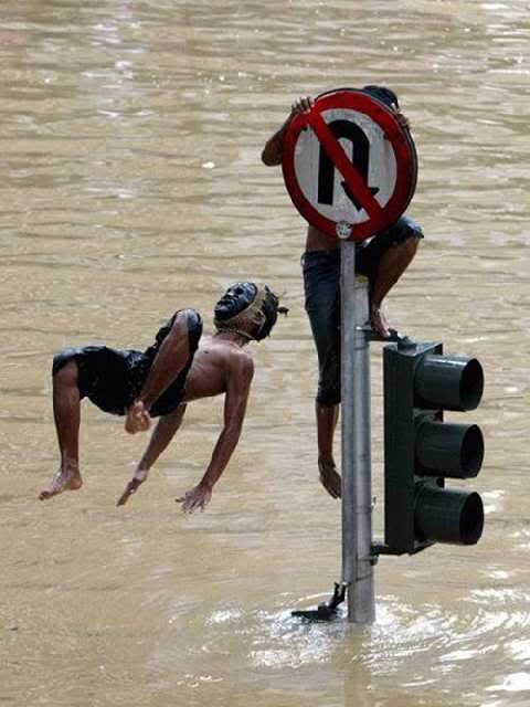
Image source:http://rahmatsetiawan.blogspot.com/2010/11/jakarta-nowadays.html

1. Abstract
The effects of climate
change on humanitarian issues can be found evident in the case of
Jakarta, Indonesia. As the capital city of the fourth most populated
country in the world, Jakarta has to endure problems that also challenge
many others mega-cites in developing countries, such as Bangkok,
Beijing, Shanghai, Mumbai, Manila, Taipei, etc. Typical problems for
these mega-cities are social problems such as overpopulation, poverty,
unequal income distribution, slums, and many more. Used to be trade
ports, these cities are usually located in the low elevation coastal
zone that make them vulnerable to climate change effects such as
level-sea rise, floods, tropical cyclones, storms, droughts, and high
precipitations. Unfortunately, almost two-thirds of all cities with more
than 5 million people fall into this zone. Sixty percent of the
population in this low elevation coastal zone is urban. (Webersik, 2010)
Jakarta, with its 9.58
million population experiences all of the above-mentioned effects of
climate change. But the greatest climate change and disaster-related
risk facing Jakarta is floodings, which inflicted very high human and
economic detriment on the city. The most affected people are the urban
poor, which constituted 3.5% of the population. They are highly
vulnerable because they live in the riverbanks and canals. The poorest
people in Jakarta settled in self-constructed settlements, usually on
land without formal legal title. This situation creates a problem with
the local authority and so often leads to clashes with the settlers. At
the same time, the people regarded the provincial government incapable
of managing the city. Migration is another problem that haunt Jakarta if
the government does not have a good policy for the city in the coming
years.
The combination of
climate change effects and social vulnerability may lead to escalated
conflict between the local authorities and the urban poor, especially
when the local government includes the use of force in managing the
problems.
2. Description
Overpopulation:
Jakarta is the economic, political, and
cultural hub of Indonesia. The Dutch colonial government founded the
city and designed to accommodate 800,000 people. However, the
centralization policies during the Suharto's office cause the city to
expand to more than 9 million inhabitants. In working weeks, Jakarta is
said to accommodate 12 million people. People from all over the country
come to Jakarta to find livelihoods and to settle down. According to
2010 UNFPA data, about 43 percent of Indonesians live in urban areas. It
is projected that by 2020, two out of three Indonesians will live in
cities. Data from the Population and Civil Registration Agency show that
there were 109,617 post-holiday newcomers in 2007, 88,473 in 2008,
69,554 in 2009 and 60,000 last year. Jakarta expects to see less than
50,000 new arrivals this year.
Jakarta Land Use in 1976, 1989, 2004
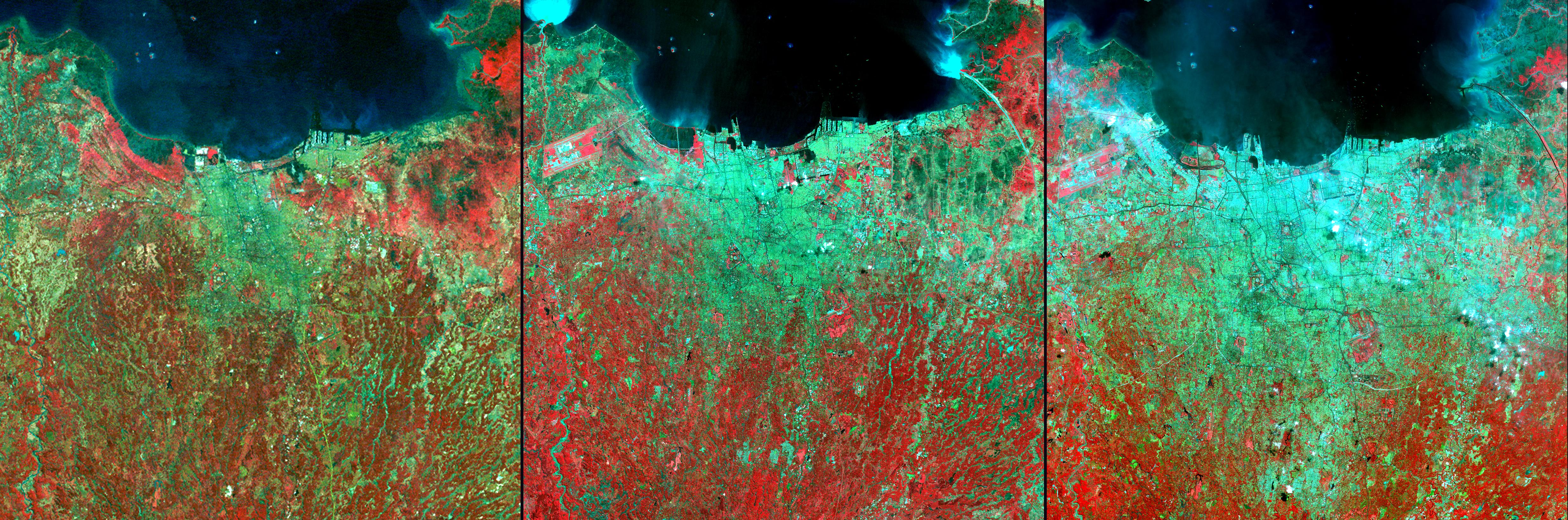
Source: http://earthobservatory.nasa.gov/IOTD/view.php?id=5693
The images above are
image of the land use of Jakarta in the year 1976, 1989, and 2004. The
images use satellite observations of visible and infrared light
reflected by the Earth's surface to enhance the contrast between land
surface types. Vegetation, which reflects infrared light very strongly,
appears red, and urban areas appear light green. Each image in this
series covers an area of 49 by 49 kilometers and is centered near 6.2
degrees South latitude, 106.8 degrees East longitude.
In the 1976 image, captured by the Landsat MSS scanner, the city makes
a green patch in image center and along the coastline, while the
surrounding area shows large areas of remaining vegetation (red). The
city spread considerably to the east by 1989, when a subsequent Landsat
mission captured the middle image in this series. By 2004, when the
final image was captured by the Advanced Spaceborne Thermal Emission and
Reflection Radiometer (ASTER) on NASA’s Terra satellite, westward
expansion had occurred as well. Nearly the whole scene appears in the
green of urban development, with few pockets of vegetation remaining.
(http://earthobservatory.nasa.gov/)
The latest national
census in 2010 put the city population at 9.58 million, with an annual
growth of 1.4 percent, or 135,000 people per year. The current
population figure exceeds the 8.9 million mark predicted by the Central
Statistic Agency in 2010. The current figure also surpasses the city's
own projection for 2025, which was forecast to be 9.2 million. With its
current population, Jakarta's 662-square-kilometer area has a population
density of 14,476 people per square kilometer. In Jakarta greater areas
(satellite cities) such as Bogor, Depok Tangerang, and Bekasi,
reportedly more than 25 million people live there. In 2020, the number
is expected to swell to 35 million. This mass migration created
innumerable problems for Jakarta, ranging from poor sanitation and
transportation to a lack of clean water and housing.
(http://sg.news.yahoo.com)
Clean water is one of
the issues faced by the population. The current piped system of drinking
water is ineffective, therefore 80% of Jakarta inhabitants use the
underground water which has become steadily depleted. In low-lying North
Jakarta, groundwater depletion has caused serius land subsidence,
making the area more vulnerable to flooding and allowing sea water from
the Java Sea seep into the coastal aquifiers. Along with sea level rise
and increased rain fall, land subsidence is one of the greatest
challenges facing Jakarta.
Another serious issues
is housing. Jakarta is unable to provide housing for all the
inhabitants. Skyrocketing land prices and rampant private sector
development that is under-regulated has resulted in a booming
real-estate market that excludes the poor. Large informal settlements
have grown over many years along waterways, natural rivers, reservoirs,
contributing to the pollution and clogging of the areas. The local
government often use this to blame the public for flooding that occurs.
On the other hand, the public accuse the authority corrupt because they
keep issuing permits for the development of business and industries
facilities such as shopping malls and factories that are not
environmentally friendly.
Climate Change:
The Urban Risk Assesment (URA) of
Jakarta reported that "the main hazards for Jakarta relate to water
management and flood control. Extreme weather events cause overloading
of the existing drainage system, while sea-level rise coupled with land
subsidence is making Jakarta increasingly vulnerable to tidal floods due
to its coastal location. Jakarta has also experienced earthquakes
(although minor, but as recently as 2009) and should be prepared for
other unprecedented geological events and tsunamis."
Below is the table that gather the main hazards along with the effects and losses (URA Jakarta):
Hazard |
Effects |
Losses |
Earthquake |
Until now small in scale with very little physical damage |
Until now no great material or life loss from earthquakes |
River flow |
Disruption
of business, damage to property, power outage, groundwater
pollution, distribution of solid waste through high and fast water
flow |
Property damage, business damage, tainting of ground water, loss of life, spread of disease and refuse. |
Floods, Inundation |
Depending
on severity can affect traffic circulation, business activity,
damage to property, power outages, displacement, and spread of
disease. |
Loss of property and businesses, spread of illness and loss of life, loss of access to clean water. |
Storm surge |
Locally
known as rob, extreme tidal floods from the sea have become more
serious in the past few years in the coastal areas of the city.
Seawater intrusion into aquifiers. |
Seawater intrusion into drinking water, damage to property including boats, halt of industry and mobility. |
Extreme temperature |
As
a result of both urbanization and loss of green space, increases in
ground temperature and resulting instances of dengue. |
Loss of life due to dengue, usually in a very poor communities. |
Bad policy:
The public and the media have expressed
negative sentiments towards the provincial government over the two
major floods in 2002 and 2007. The Jakarta Post during the 2007 floods
ran an editorial that said, "if any head must roll for the poor
handling of the disaster, it is Sutiyoso's (the then governor), and his
alone. It is simply unforgiveable
for a governor to see two major floods hit the city, and on both
occasions leave the citizen helpless (Jakarta Post, 5 February 2007)."
The governor is elected by the people since 2007, however, criticsm and
mistrust towards the local authority are the norm among the Jakartan
public.
Florian Steinberg in his paper for the
Habitat International asserts that “the administration’s budget is often
criticized for not reflecting the ‘‘priorities of the people’’ (Jakarta
Post 11 January 2002). While the city budget is generous in allowance
for the Governor and his top officials as well as the members of the
Provincial Council, there is a chronic phenomenon of under-spending of
the development budget. In the last years, the pattern has always been
that during the first 6 months of a year the city administration was
only able to spend a mere 25% of the development (investment) budget,
while during the second half of the year the expenditure of funds was
either haphazardly accelerated or money was not spent at all since
project preparation and procurement took up much more time than
anticipated.” Clearly, a better budget utilization is urgent on this matter.
The video below is a video by the World
Bank that captures the perspective of the local government, central
government, and the Jakartan people on the issue of Jakarta flood:
3. Duration: 10 - 100 years
Beginning year: 2002
End year: On going
Duration: 50 years and on
The major floods take place every 5
years. The first major flood was in 2002, followed by the largest floods
of the city's history in 2007. It is predicted to take place again in
January 2012.
4. Location
Jakarta in the World Map
Source:http://quehoraesen.net/en/jakarta
Continent: Asia
Region: Southeast Asia
Country: Indonesia
Province: Special Capital Region of Jakarta (DKI Jakarta)
Jakarta is located on the north coast
of the island of Java in the Indonesia archipelago in Southeast Asia.
Often referred as a big city, Jakarta is actually a province that
comprises of five municipalities Central Jakarta, North Jakarta, East
Jakarta, West Jakarta, South Jakarta, and Thousand Islands regency.
Central Jakarta (population: 889,448) is the most densely populated and a
home of to most of the city’s skyscrapers. North Jakarta (population:
1,445,623) is the most climate change affected neighborhood because of
its proximity to the coastal area. East Jakarta is the most populous
district with 2,391,166 residents. West Jakarta has a population of
2,093,013 residents. South Jakarta is considered the most well-off
neighborhood with a population of 2,001,353 people. Thousand Islands
comprises about 110 big and small islands, and is a tourism spot.
People live in Jakarta representing
nearly all the ethnic groups in the archipelago. The major groups are
Sundanese, javanese, Chinese, and the native Betawi. Other large groups
are the Minangkabau people, the Bataks, the Manadonase, and the other
people from Sulawesi and the Ambonase.
5. Actors
- Provincial government
The provincial government holds the utmost responsibility of the
situation in Jakarta. They have been regarded as incapable of managing
the city, and that their policy is excluding the poorest communities of
Jakarta.
- Jakarta residents
The public of Jakarta has the role to push the local government to
formulate better policies that is pro-poor and environmentally friendly.
- The business people
The business people in Jakarta are able to play an important role by
running their business with an environmental awareness in mind. They
also can play a role in incorporating environmental project on their
corporate social responsibilities programs.
6. Type of Environmental Problem: Climate Change
There have been numerous studies on the
effects of climate change to Jakarta environment. A study by Indra M.
Surbakti et.al in 2010 concludes five major environmental problems in
Jakarta:
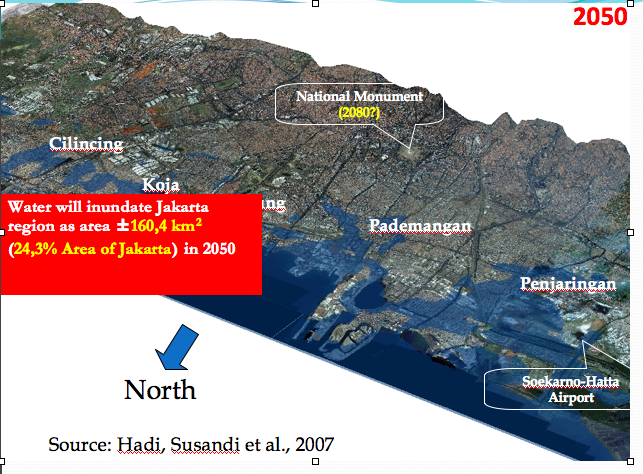
1. Floods caused by Rainfall, Temperature, and Sea Level Rise
A study conducted by The Center for Sea and Coastal Development at
Bandung’s Institute of Technology (2007) concluded that the sea water
level off the coast of Jakarta increased by 0.8 meter. It was also
projected that by 2050 some areas in Jakarta, such as Kosambi,
Penjaringan, and Cilincing will be under water if global warming
continuous at the current pace. The sea level rise is projected to
inundate most of Central Jakarta and will likely cause a significantly
large socio-economic impact. Climate related hazards that frequently
occurred in Kamal Muara (Penjaringan Sub-district) are sea level rise,
flood caused by sea water or high tide, and climate uncertainty.
Below is the image for the model of
Jakarta inundation in 2050, taken from the slides of Dr. Armi Susandi,
Indonesian climate change expert:
2. Inundation caused by Sea Level Rise and High Tide
The Coastal Vulnerability Index (CVI) Mapping of Jakarta, Tangerang,
Surabaya, Pekalongan, and Bekasi by Board of Ocean and Fisheries Researh
(2009) using Haesller & Timmer, USGS (2001) has shown that there
are 4 (four) sub-districts in Jakarta which experienced flood caused by
Sea-Level Rise.
3. Heat Stress caused by Urban Heat Island
Fifty percent reduction in urban green
space would bring air temperature to rise between 0.4 to 1.8 degree
Celcius and automobile density is found to be the most important cause
of urban heat island in Jakarta.
4. Disease Outbreak and water scarcity caused by Rainfall and Air Quality
Based on a study by Haryanto (2009), diseases stemming from vehicular
emissions and air pollution include acute respiratory infection,
bronchial asthma, bronchitis, and eye and skin irritations (Boer et al.,
2007) and it has been recorded that the most common disease in northern
Jakarta communities is acute upper respiratory tract infection – at 63%
of total visits to health care centers (Indriyanti and Pedrique, 2006).
5. Water Scarcity, Air Pollution, and GHG Emissions
Water scarcity is an additional issue as a result of global and
regional climate change in which between 2010 and 2015 the country is
predicted to experience a major clean water shortage, and this is
expected to occur mainly in urban areas (Boer et al., 2007). Air
pollution is proven to be a major environmental hazard to residents in
Jakarta, regardless of their socio-economic status. Transportation
comprises 27 % of Indonesia’s GHG emissions, and traffic congestion is a
huge problem in Jakarta (Pelangi, 1999).
(Excerpted from their study titled "Jakarta City Report: Information Related to Climate Change in Jakarta City" in 2010 with necessary changes).
7. Type of Habitat : Tropical
Jakarta is located in a deltaic plain
crisscrossed by 13 natural rivers and more than 1,400 kilometers of
man-made waterways. About 40% of the city, mainly the area furthest
north near the Java Sea, is below sea level.
Geologically, the whole plain
consists of Pleistocene sediments contained in the 50 m below ground
surface. The southern part of Jakarta consists of alluvial layer, and
coastal lowlands are being stretched to the countryside about 10 km. At
the bottom, the older sediment layers do not appear on the surface of
the soil because they are entirely buried by alluvium deposits. In the
northern part of the new found, at a depth of 10-25 m, increasing to the
south of the shallow hard surfaces 8-15 m. In certain parts there is
also a hard ground surface layer with a depth of 40 m.
The climate in Jakarta is
generally hot climate with maximum temperatures ranging from 32.7 C -
34 C in the daytime, and minimum air temperature ranges from 23.8 C
-25.4 C at night. The average rainfall is 237.96 mm throughout the
year, during the 2002-2006 period the lowest rainfall of 122.0 mm
occurred in 2002 and high of 267.4 mm occurred in 2005, with humidity
levels reaching 73.0 - 78.0 percent and the average wind speed reaches
2.2 m / sec - 2.5 m / sec. (http://www.jakarta.go.id)
8. Act and Harm Sites:
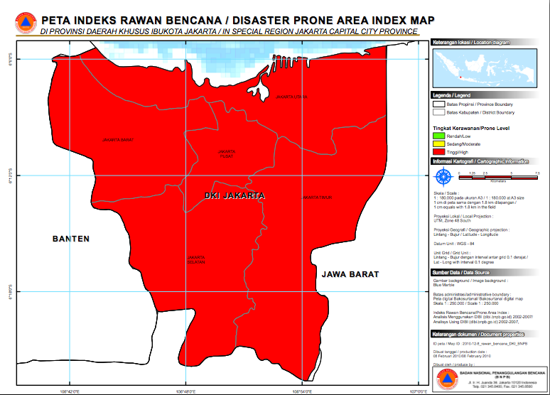
"All of Jakarta is considered at high
risk to disaster, since few areas of the city are immune to recurrent
floods. Red color indicates high disaster prone areas. However, the most
vulnerable areas of the city are those along the coast, since they are
susceptible not only to the effects of tidal flooding from the sea, but
also floods from the rivers and canals that are discharged into the
Jakarta Bay." (Jakarta Case Study Overview, worldbank.org)
The area along the coast, northern
Jakarta, is also potential for massive migration in the event of the
realization of the inundation scenario by the 2050.
9. Type of Conflict: Civil
Humanitarian issues, social unrests, migration
10. Level of Conflict: Threat
Low, Natural Environmental Changes
Currently, the conflict between the
people and the local authority is not an overt one. Negative sentiments
and blaming each other over the disasters and social problems are
expressed in the daily conversation as well as in the media. However,
some clashes have taken place in the event of evictions of the poor
people live in the illegal settlements such as along the riverbanks and
canals.
Environmental project such as the
building of sea walls in the northern part of Jakarta is potential of
violent conflict if the local government include the use of force to
remove people fom their illegal settlements.
Migration and business disruption will also be problems whenever the hypothetical inundation by 2050 actually become reality. Java
island, where Jakarta is located, is the most densely populated island
in the country, migration from Jakarta will affect the social and
political stability in the migration destination as well as in Jakarta
itself.
11. Fatality Level of Dispute (military and civilian fatalities)
In 2007, United Nations Office for the
Coordination of Humanitarian Affairs (UNOCHA) reported that 80 people
had died in the floods, and 16,030 remained displaced. The most affected
people are the urban poor, which constituted 3.5% of the population.
The February 2007 flood cost 57 lives, displaced more than 422,300
people, and destroyed 1,500 homes, damaging countless others. Total
losses to property and infrastructure were estimated at USD 695
million.10 (http://www-wds.worldbank.org/)
Human casualties have yet occured in the conflict between the local authority and the people.
12. Environment-Conflict Link and Dynamics:
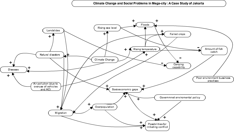
Climate change
causes more disasters as the temperature and sea level rises. The rising
of the temperatures causes more floods, droughts, and more failed
crops. Located in the tropical climate where the temperature is
naturally warm, the rising of the temperature in Jakarta affects the
lifestyle of the vast population. The people overuse the vehicles and
air conditioner, which resulted in severe air pollution. In turn, air
pollution affects the temperature to rise, and this situation creates a
cycle that exacerbated one another. The raising sea levels and
temperature affects the fishermen in terms od decreasing fich catch.
Indonesians are
agrarian in nature. They used to be farmers and fishermen. Today, there
is a decreasing tendency of people choosing to be farmers and fishermen
as their occupation. Agrarian lifestyle can no longer ensure their
livelihoods due to the uncertainty of the climate.
People from all over the country
are attracted to migrate to Jakarta because it offers more jobs and it
causes overpopulation to the city.
The environmental
problem in Jakarta is also caused by the poor awareness of the
population and authorities dealing with environmental issues.
Environmental matters are considered less significant compared to
economic growth. The provincial government focuses on the development
for economic purposes such as building shopping malls, hotels,
residences. The business people do not have the environmental awareness
as well. These environmentally-poor practises are also being taken for
granted by the authority which leads to mismanagement of environmental
aspects.
The combination of
natural disasters, man-made disaters and urbanization, lead to
overpopulation and broad socioeconomic gap, which in turn will be the
sources of social vulnerability in mega cities such as Jakarta. Since
the environmental problems usually have more effects to the poorer
poopulation, the local authority does not prioritize them. They keep
issuing permits to build more shopping malls and other facilities that
sacrifices the environmental aspect. Their policies are not considered
pro-poor. The people and NGOs are calling for urgent attention from the
local government for this matter. The indifference from the local
government may increase the possibility of initiating conflict between
the people and the government. Violence may occur when the authority
relies on the use of force to manage the problem.
13. Level of Strategic Interest
National, low to medium
Jakarta is the most important city that
serves as the center of political and economic activities in the
country. Any major disruptions in the city will have implications in the
national level.
14. Outcome of Dispute: In Progress
There has been no overt violence dispute until now. However, potential violence may involved, in terms of the forced removement of the illegal settlers in slums areas in Jakarta.
15. Related ICE Cases
KALIMAN Ethnic Conflict and Deforestation in Kalimantan, Indonesia , by Dianne Linder
16. Relevant Websites and Literature
Webersik, Christian. Climate Change and Security: A Gathering Storm of Global Challenges. Santa Barbara: Praeger, 2010.
Indra M. Surbakti, Izhar C. Idroes, Hendricus A. Simarmata and Tommy Firman. Jakarta City Report: Information Related to Climate Change in Jakarta City. 2010
(http://sg.news.yahoo.com/daytime-population-12-million-jakarta-overpopulated-084006590.html)
(http://earthobservatory.nasa.gov/IOTD/view.php?id=5693)
(http://www.jakarta.go.id/jakv1/item/halaman/0/0/494/1/1/2/3/3/1/4/3)
(Jakarta Case Study Overview, worldbank.org)
(http://www-wds.worldbank.org/)
[7 December 2011]