
| ICE Case Studies
|
|
I.
Case Background |
Lake Chad is a endorheic lake, meaning it is inland and has no route to the ocean. It was once one of the largest inland lake of Africa. Due to drought and over-use the volume of water has collapsed and the lake is in danger of disappearing. The people in the area are largely in the agricultural sector, with high poverty and illiteracy. With the loss of the water for many differing livelihoods, incomes and lives have become more perilous. This makes the area ripe for extremism.
Around 5,000 BC Lake Mega-Chad was one of the four large paleo-lakes that existed in the modern area of the Sahara Desert. It was around 400,000 miles in surface area, or larger than today's Caspian Sea (though not in volume). The Mayo Kébbi River drained the lake to the Atlantic Ocean with ocean growing animals such as manatees travelling upstream to the lake.
The Sahara Desert was a very different place at this time. With the end of the Ice Age and the onset of the Holocene Era, rainfall was plentiful as the melting glaciers in Europe pushed weather patterns southward. There remain many indicators of the ancient humans who lived in the area, etched upon stones in the Sahara. The etchings (petroglyphs) are found throughout the western U.S. as well.
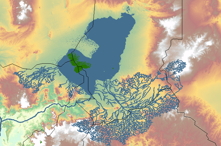
Creative Commons, https://commons.wikimedia.org/wiki/File:Megatschad_GIS.PNG
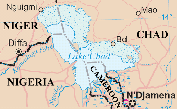
Lake Chad is mainly in the far west of Chad and borders with Nigeria. The Chari River, provides over 90% of the lake's water. Other sources are the Logone River, a tributary, and a small amount coming from the Yobe River.
Over half of the lake's area is taken up by its many small islands (including the Bogomerom archipelago), reedbeds and mud banks, and a belt of swampland across the middle divides the northern and southern halves.
Lake Chad is very shallow, only 34 ft at its deepest. Thus, it is sensitive to small changes rainfall. Because of the very low average depth, the lake shows high seasonal fluctuations in size. There is moderate rainfall from July through September. Thus, there is great seasonal variation in size. The actual water volume of the lake is quite low compared to African lakes.
Since the 1960s, the lake has dramatically shrank. At that time it covered 10,000 square miles. By 2000, its lake area had fallen to 580 sq miles. In 1964, the Lake Chad Basin Commission was created by Nigeria, Cameroon, Chad, and Niger, the four countries abutting the lake. The Central African Republic, Algeria, and Sudan are also within the basin.
Coe and Foley produced a 2001 study (Journal of Geophysical Research found the leading cause of water loss due to overgrazing, causing desertification and a decline in vegetation. UNEP (the United Nations Environment Programme) argues that at least half of the lake's decrease is due to shifting climate patterns.
Lake Chad lies in Chad but near to the Nigeria and Cameroon borders.
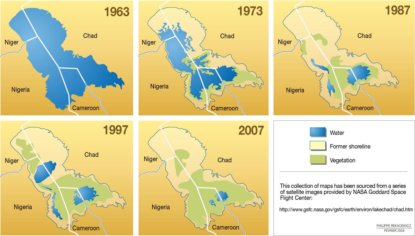
This image is a map derived from a United Nations map. It shows the lake over recent history. In 1963, the lake had significant shorelines in each of the four major bordering countries. By 1973, there had been significant drying, especially in the areas in Niger and Chad. By 1987, the lake had dried up in Niger and in Nigeria only disconnected pockets of water existed. The lake proper existed only between Cameroon and Chad. In 1997, the lake water levels rebounded and a section re-appeared between Niger and Nigeria. Unfortunately, by 2007, the lake was only a shallow pond between Chad and Cameroon. Most of the lake bed was vegetation, probably marshlands. The lake was mostly gone by then.
https://en.wikipedia.org/wiki/Lake_Chad#/media/File:Lakechad_map.png
https://library.ecc-platform.org/conflicts/lake-chad-africa-inter-state-conflicts-and-cooperation
Most of the water loss is attributable to human use or siphoning off of inflowing rivers for agriculture. However, the drying of the climate in 5,000 BC and today continues to cause the lake to shrink in size. Human activities have accelerated that process.
Outside of the lake and the wetlands, the area is arid to semi-arid. The area has 30 million inhabitants and the population is growing rapidly. It is possible hat the lake will disappear this century.
The boundaries around Lake Chad completely reflect pre-World War One colonial arrangements among European powers. A boundary was set that reflected French interests in Chad and Nigeria, British interests in Nigeria, and German interests in Cameroon. Germany lost the colony after the World War and the countries became independent after World War Two.
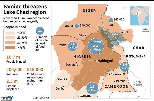
One indicator that has been suggested to foreshadow conflict is children's health. For poor countries especially, they are often the most rapidly impacted by the onset of instability. "Malnutrition has worsened in Chad’s western Lac region. Global acute malnutrition stands at 18.1 per cent, above the 15 per cent emergency threshold and worse than the 2016 rate (12.2 per cent). Severe acute malnutrition has also increased from 2.1 per cent in 2016 to 3.4 per cent in 2017, but remains slightly below the national average. In Cameroon, 40 per cent of children under five in Far North region are struck by chronic malnutrition." UN OCHA
Despite the lake, the instability has disrupted farming and ranching, leading to a regional famine.
SIPRI estimates that Boko Haram killed at least 10,000 between 2009 and 2016.
"167 Boko Haram Fighters Captured Around Lake Chad, Says Army", Sahara Reporters, December 16, 2017.
http://saharareporters.com/2017/12/16/167-boko-haram-fighters-captured-around-lake-chad-says-army
In addition, there is an ISIS affiliated group
insurgent group operating across several countries including Algeria and Mali.
https://www.sipri.org/commentary/expert-comment/2017/unfolding-humanitarian-crisis-around-lake-chad-un-report-falls-short-naming-environmental-dimensions
The US Army is adding resources the the lake area given the instability caused by a 90 percent drop in water levels since the
1960s.
https://www.army.mil/article/195852/us_army_africa_pushing_more_support_to_lake_chad_basin_to_reinforce_us_stability_efforts
http://allafrica.com/stories/201709200940.html
The loss of the lake water's has caused conflict between the differing local users of the resource,
including, farmers, ranchers, and fishermen. In addition, Islamic movements such as Boko Haram
brought conflict to the region.
"Around 17 million people live in the affected areas across the four Lake Chad basin countries.
More than 2.3 million people remain displaced. Most of the displaced families are sheltered by
communities that count among the world’s poorest and most vulnerable.
Food insecurity and malnutrition have reached critical levels." UN OCHA
Regional countries have proposed restoring water but no concrete plans are underway. One prominent idea is to divert
waters from a southerly river (such as the Ubangi) to revive the lake's water levels.
This conflict is ongoing with no end in sight. The direct violence and the indirect influences -- 2 million displaced and economic disruption --
can only lead to further conflict and resentment.
Go to Ice Search Engine and Scenario Builder
Coe, Michael T.; Foley, Jonathan A. (2001). "Human and natural impacts on the water resources
of the Lake Chad basin". Journal of Geophysical Research.
106 (D4): 3349–3356. Bibcode:2001JGR...106.3349C. doi:10.1029/2000JD900587.
UN Office for the Coordination of Humanitarian Affairs:
To learn more about OCHA's activities, please visit http://unocha.org/.
10. Level of Conflict: Low
11. Fatality Level of Dispute (military and civilian fatalities): 1,979-10,000
https://data.humdata.org/dataset/conflict-events/resource/eb3f309b-3ed4-45cd-a503-4fe779698359
IV. ENVIRONMENT AND CONFLICT OVERLAP
12. Environment-Conflict Link and Dynamics: Indirect
13. Level of Strategic Interest: Regional
14. Outcome of Dispute: In Progress
V. SOURCES
15. Related ICE Cases
16. Relevant Websites and Literature
"Lake Chad: Inhabitants adapt to lower water levels". sciencedaily.com.