ICE Case Studies |
Climate Change, Extreme Weather Events, and Violent Conflict in Pakistan By Carmen Radu |
I. Case Background |
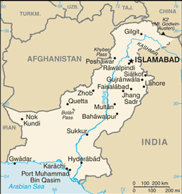
Figure 1 Pakistan Political Map
Source: CIA World Factbook
 I. CASE BACKGROUND
 This case study contributes to the environmental security literature on the link between climate change and violent conflict. Climate change has already begun to exacerbate existent ethnic strife and conflict in Pakistan.The case study shows how the summer 2010 floods have affected three main concerns: the fight against violent Islamists, ethnic strife in Karachi, and the Baluch separatist conflict. The climate change-induced floods have dramatically impacted the Pakistani political arena as the disaster relief process decreased the legitimacy of the civilian government and increased the legitimacy of both the military and Islamists. These developments have implications for democratization and thus long term peace. By delving into such sociopolitical impacts of disaster relief, this study also contributes to scholarly attempts to bridge the communities of climate change, environmental disaster, and development. Helmer and Hilhorst for example, have called for such integrated approach, arguing that climate change is not solely manifested as slow change over a long period of time, but is also manifested as extreme weather events. These have devastating consequences in more vulnerable countries. This vulnerability can be mitigated through development (Helmer and Hilhorst 2006, 1-4). Finally, the case study contributes to the literature on climate change and counterterrorism. American counterterror policies are based on the idea of well-governed states that are able to cooperate. Climate change threatens potential for good governance because it increases poverty and reduces capacity, factors that create a functional space for terrorists to exploit (Smith, 2007). The case of the 2010 Pakistan floods therefore links environmental security, disaster management, development, and counterterrorism theories.
Figure 2 Pakistan Administrative Map
Source: Maps of World
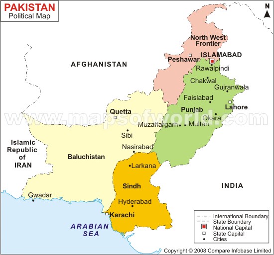 In order to understand how a climate change-induced extreme weather event has exacerbated conflict in Pakistan, it is important to first understand basic characteristics of the country. Pakistan is a federal republic covering an area of 796,095 square km, whose capital is located in Islamabad. Pakistan has four provinces and one federally administered tribal area (see figure 2 below). The country is located along the Indus river valley, where civilization took root 5,000 years ago. The territory of what is today Pakistan was part of the British Empire, and the state's borders are a result of the post-colonial legacy. The borders were delineated in 1947 (CIA, 2010). This legacy is the major cause of Pakistan's dispute with India over the territory of Kashmir.
As of 2010, Pakistan's population is 184, 404, 791. The country has a Total Fertility Rate of 3.28 (CIA, 2010). This indicates significant population growth, which does not bode well with the country's low level of economic development. Ranked by GDP/capita, Pakistan is 178th in the world, and 24% of the population is below the poverty line (CIA, 2010). The overwhelming majority of the populace is Muslim. Ethnic composition is the following:
| Punjabi | 44.68% |
| Pashtun | 15.42% |
| Sindhi | 14.1% |
| Sariaki | 8.38% |
| Muhajirs | 7.57% |
| Other | 6.28% |
| Balochi | 3.57% |
These characteristics lead to the conclusion that Pakistan is an impoverished, post-colonial, multi-ethnic state in the front lines of global counterterror efforts, that is experiencing population growth. These factors make the country highly vulnerable to destabilization due to climate change. The floods have affected all of Pakistan, placing additional socioeconomic strains. Twenty million people have been affected by the floods, 10 million of which are short of food. An estimated 1,600 people died (New York Times, 2010). Furthermore, one fifth of the cotton and cane crops, two million homes, 3,000 miles of road, and 7,000 schools were destroyed. GDP growth has been constrained (The Economist 2010, 1-5). The country is on the verge of a food crisis and 6 million people at risk of starvation (Bajoria, 2010).
The floods occurred in the summer of 2010, starting in July. However, the effects on Pakistan's stability and development are ongoing.
Pakistan is located in South Asia, within the latitude and longitude of 30 degrees N, 70 degrees E (CIA, 2010). The country borders Afghanistan, Iran, India, and China, and has an opening to the Arabian sea (see figure 1).
The main actors involved are Pakistani civilians, the civilian government and military, and Islamist fighters.
II. Environment Aspects
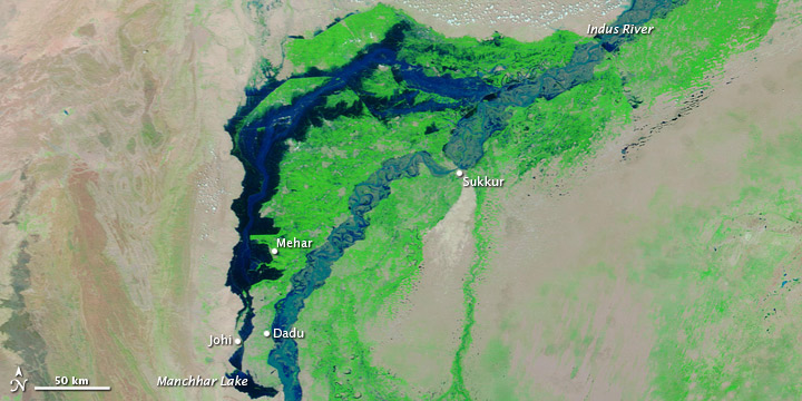
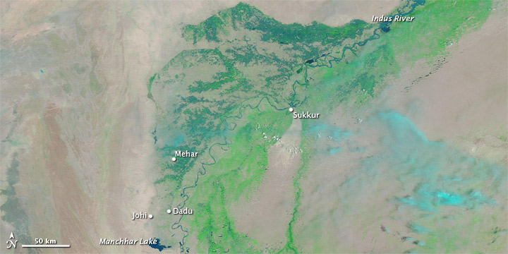
Pakistan has a number of environmental concerns, such as deforestation, soil erosion, desertification, and limited fresh water resources. Pakistan is also located in a region prone to severe earthquakes in the north and the northwest (CIA, 2010). The type of environmental problem relevant to this case study is susceptibility to flooding due to the monsoon season. Climate change has worsened the monsoon season that regularly affects South Asia. Intergovernmental Panel on Climate Change studies show that because of climate change, mega-delta regions in South Asia are at increased risk of flooding, as well as increased frequency and intensification of rainfall and winds (IPCC, 2007). The summer 2010 floods in Pakistan are considered the worst in 80 years (New York Times, 2010). The increased precipitation of the monsoon season flooded the Indus. The progression of the swelling of the Indus can be seen below in figure 3. The maps show that within three months, the Indus and its tributaries flooded, affecting most of the country. The flooding began in the north of the country, proceeding to the southern and eastern parts.
Figure 3 Progression of Indus River Flooding
Source: NASA Earth Observatory
July 19, 2010
August 11, 2010
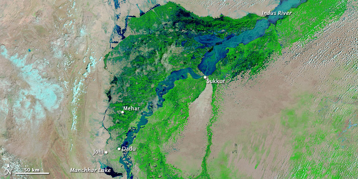
September 7, 2010
Pakistan has multiple climatic zones. The country is largely characterized as hot dry desert. The north and northwest are mountainous regions, and the climate is temperate in the northwest and arctic in the north. The east is flat, plain terrain (CIA, 2010).
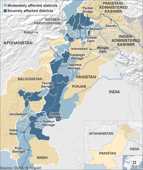
The floods affected most of the country. Figure 4 below depicts a map of the affected districts and the degree of severity. As seen, the districts neighboring the Indus have been hardest hit.The map shows that the floods severly affected the districts of the Frontier region, which is the site of a revolt against the government. The eastern part of separatist Baluchistan was also severly affected.
Figure 4 Affected Districts
Source: BBC
III. Conflict AspectsThis section provides background on each of the three conflicts that the floods have exacerbated. These conflicts preceded the floods. The impact of the floods on these conflicts is discussed in section IV.
Counterterrorism in Frontier Region
Figure 5 Frontier Region
Source: Amnesty International
 Pakistan's western frontier is the main area of concern for global counterterror efforts. This region is comprised of the Federally Administered Tribal Areas and the North-West Frontier Province, also known as KPP (see figure 5 below). Islam has been politically expressed in this region for centuries, before the state's creation. For the last thirty years, the region has been a focal point for religious extremism. This is where the mujahidin sprung up to fight the Soviet occupation of Afghanistan during the 1980s. Al Qaeda sprung up in 1988, and the Taliban in 1994. Currently, a neo-Taliban insurgency in the region aims to overthrow the Afghan government, to provide a safe haven for Al Qaeda, to destabilize the Pakistani state, and to gain influence and establish Islamic rule in all of the tribal areas (White 2008, 3-6).
Karachi
The Karachi situation can best be described as ethnic strife or sectarian violence. Karachi is the capital city of Sindh province (see figure 2). Founded in 1729, the city was part of the British Empire and then became part of Pakistan. Between 1947 and 1951, refugees from India settled in Karachi and came to be known as the Mohajirs. Today, Mohajirs are the major ethnic group, struggling for political power with the Sindhi, the Pashtun, and the Baluch. The city has structural problems that fuel strife. The fast population growth that occurred between 1941 and 1961 led to illegal housing settlements, because the infrastructure could not catch up to the needs of the growing population. These settlements grew in size with the arrival of migrants from Punjab, Baluchistan, and the frontier region. Migration into Karachi has been driven by the Afghan conflicts that started in the 1980s, and by pull factors related to the city's status as commercial and economic hub. Today, the city is made up of ethnic enclaves controlled by private militia (Gayer, 2007).
Baluchistan
Baluchistan is mainly a secular, separatist conflict, but it is susceptible to Islamist manipulation, which ties the conflict to global counterterrorism efforts. Baluchistan was annexed by Pakistan in 1948 (see figure 2). It is Pakistan's largest province but contains only 5% of the population; 45% of this population lives below the poverty line (Mullen 2005, 16). Because the region shares a long border with Afghanistan, the Taliban have a safe haven in Baluchistan, especially in northern Baluchistan. The two main aspects of the conflict are the strength of the Taliban in the region, and the unaddressed grievances of the separatists, which are exploited by the Taliban. Baluchistan is a resource rich province, yet it is the least developed. Baluch view the government as exploiting their natural resources and excluding them from development efforts. Experts believe that the Taliban and the separatists cooperate to destabilize the government (Mullen 2005, 1-20).
10. Level of Conflict: Low
All three cases can be considered low-intensity intra-state conflicts. Within each case, the level of conflict and degrees of fatality fluctuate. The cases of Karachi and Baluchistan in particular can be considered ethnically-driven livelyhood wars.
11. Fatality Level of Dispute:
14,500 (2005-2009, F.A.T.A &N.W.F.P)
400 (1985-2010, Karachi)
+6,000 (1973-present, Karachi)
Counterterrorism in Frontier Region
Figure 6 Frontier Violence
Source: Amnesty International
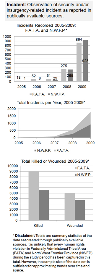
Since the 9/11 terrorist attacks and Operation Enduring Freedom in neighboring Afghanistan, Pakistan's frontier area has been extremely important in global counterterrorism efforts. These efforts are best characterized as counter-insurgency (Peters, 2010).The Pakistani military has initiated campaigns in the frontier region, the latest being in 2009 after an increase in insurgent activity. The government gained back some territory and constrained terrorist activity. The insurgent groups are comprised of Pakistani Taliban, foreign jihadists, and criminal gangs. In addition to the Pakistani government, the U.S. military also engages in regular drone attacks (Peters 2010, 10-20). Figure 6 below shows detailed information on the numbers of military and/or terrorist incidences reported between 2005 and 2009. The level of conflict significantly increased in 2008, in both the Federally Administered Tribal Areas and the North West Frontier Province. Between 2005 and 2009, at most 9,000 people were killed and 5,000 wounded; these include military and civilian deaths. The most recent government offensive resulted in the displacement of approximately 2 million people. The types of methods used in the conflict include air strikes, drone attacks, ground based attacks, explosives, suicide attacks, executions, kidnapping, arrests, and other insurgent violence, such as destruction of schools (Amnesty International, 2010).
Karachi
The first major ethnic riot in Karachi broke out in 1985, in which approximately 100 people died (Gayer, 2007). There are 16 million people in the city. Since 2008, killings among ethnic groups and political parties left 300 people dead. One major dimension that fuels the conflict is the city's role as a supply route for the Afghan war, lending easy access to a large amount of illegal weapons (Masood and Imtiaz, 2010).
Baluchistan
The conflict level in Baluchistan fluctuates. The central government initiated military campaigns in Baluchistan in 1948, 1958, and 1973. The government crushed all three insurgencies. 6,000 Baluch and 3,300 Pakistani soldiers died in the 1973 operation (Mullen 2005, 12). The latest uprising against the central government began in 2003 and is being led by the Baluchistan Liberation Army; the goal is to achieve independence. Because of the government's violent handling of the situation, many Baluch youth have lost faith in the use of diplomatic means. Another campaign in 2005 killed hundreds and left thousands internally displaced (Mullen 2005, 15-19). Human rights groups report rampant cases of rapes, tortures, and killings of youth by military forces, and more than 4,000 cases of enforced disappearances. The central government does not allow local and foreign media in the region (UNPO, 2009).
IV. Environment and Conflict Overlap
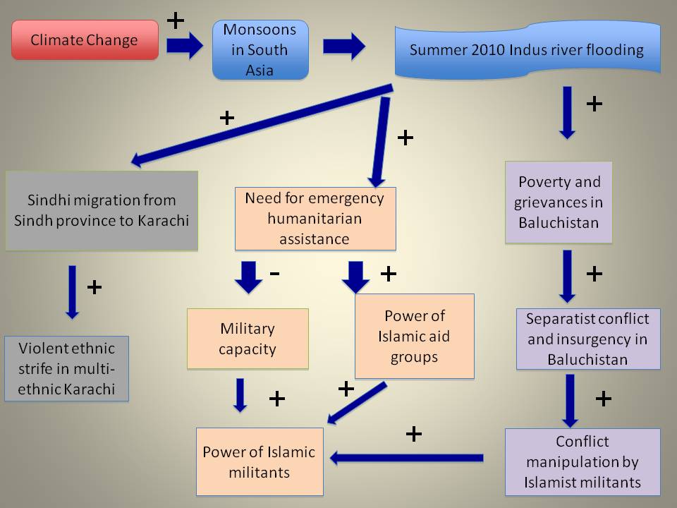
The following diagram shows how the climate change-induced floods have exacerbated the three conflicts, represented by three different colors. In the tan-colored boxes, I make the case that the need for humanitarian assistance decreased military capacity and increased the power of Islamist aid groups. These two factors increased the power of Islamist militants, thus prolonging the counterterror conflict in Pakistan. Some Islamist aid groups are separate wings of Islamist militant organizations, hence the two can be conceptually separated. In the grey-colored boxes, I make the case that the flooding of Sindh province increased Sindhi migration into multi-ethnic Karachi leading to ethnic strife. In the lavender-colored boxes, I argue that the flooding has increased poverty in separatist Baluchistan. This is causing heightened tension with the central government due to increased grievances. Experts fear that Islamist militants can manipulate and exploit the latter two situations. In the below sections, I discuss each conflict in more detail.
Counterterrorism in Frontier Region
Due to Pakistan's on and off history of military rule, civil-military relations are unbalanced and the civilian leadership's legitimacy is fragile. The last military rule period ended in 2008 with the resignation of general Pervez Musharraf. The floods have weakened the legitimacy of the civilian leadership because the leadership has been unable to effectively provide disaster relief, as exemplified by the slow dealings of the National Disaster Management Authority. In addition, district officials, who are the main dispensers of public services, cannot be relied upon. The fact that president Zardari visited France in the worst days of the floods did not bode well with the populace. By contrast, the military has effectively conducted search and rescue operations, equipped with boats, helicopters, and 70,000 troops on the ground (The Economist 2010, 3-4). The military's heavy involvement in disaster relief has diverted resources away from counterterrorism, and constrained its ability to fight violent Islamists in the frontier region. Recent gains made in the region's Swatt valley have now been set back. The Taliban have actually regrouped in the area of Mohmand, near the Afghan border, which the military thought it conquered. Furthermore, the military's plans to invade northern Waziristan have now been cancelled (The Economist 2010, 4).
Another aspect is the rise in legitimacy of Islamist aid organizations, which have also been able to provide fast and effective disaster relief in the flooded areas. There are a number of quasi-political Islamist organizations in the country, such as Tehrik-e-Taliban-e-Pakistan, TNSM, and Lashkar-e-Islami (White, 2008). Some aid organizations operating in Pakistan are tied to the militant arm of these groups. Furthermore, there is a high chance of recruitment of vulnerable populations who would accept their humanitarian services (Congressional Research Service, 2010). Sindh and Punjab, areas heavily affected by the floods, have a history of being fertile ground for recruitment, due to the poverty (The Economist, 2010). By exacerbating poverty, the floods only heighten these dangers.
Karachi
Karachi's status as the capital of Sindh province has made it an attraction point for thousands of the internally displaced (IDPs) fleeing flood-stricken Sindh province. This influx has increased ethnic tensions and even led to clashes, because of the city's low carrying capacity. In one post-flood incident, police fired on a crowd of IDPs, who settled in unoccupied private apartments in the city, after not being accepted into IDP camps due to overpopulation. The incident resulted in 45 deaths (Wright, 2010). In October, gunmen opened fire in a commercial neighborhood, leading to the death of 12 people who were of mostly Pashtun and Baluch ethnicity. Sixty more people died over the course of four days, schools were closed and public transportation was suspended. The government sent in paramilitary troops to attempt to quell the violence (Masood and Imtiaz, 2010).
Baluchistan
Flash floods started hitting Baluchistan on July 20th and have killed hundreds of people there. The floods affected the districts of Barkhan, Kohlu, Naseerabad, and Sibi. The provincial government has fewer resources to handle disaster relief in comparison to other provinces UN-HABITAT, 2010). The UN High Commissioner for Refugees expressed distress at the relatively low level of attention that Baluchistan has been receiving in the disaster relief process. He stated that the mainstream media forgot about the flood victims there, and that their needs remained relatively unmet (The Express Tribune, 2010). The prolonged effects of the recent floods have exacerbated grievances, and accusations of politicized disaster relief. These factors only embolden the conflict.
The level of strategic interest that this case study arises is regional. Due to the counterterrorism link, Pakistan is very important for U.S. strategic interests in the region. India is also an important regional factor, as the conflict over Kashmir has soured relations between Pakistan and India. Often times, Pakistan perceives India as meddling and taking advantage of any internal problems Pakistan may have. In addition, Pakistan and India are both nuclear states.
The table below displays causal factors in the three conflict situations, and determines the role that climate change plays in each (see table 1).
Table 1 Outcome
Conflict |
Other Factors |
Climate Factor |
War to defeat Islamist militants |
International pressure to combat Islamist militants |
High Overstretched military due to military control over relief efforts, countering recent military gains Low popular approval of the civilian govt.'srelief Growth in popular support for Islamist organizations due to their humanitarian assistance |
Ethnic strife in Karachi |
History of ethnic violence |
Medium-increased migration into Karachi of people from one ethnic group: Sindhi |
Separatist conflict in Baluchistan |
Poverty and historical grievances
|
Low |
V. Related Information and Sources15. Related ICE Cases
ICE No. 78-Kashmiri Kashmir
ICE No. 229-Climate Change Induced Extreme Weather Events & Kashmir Sea Level Rise in Bangladesh Leading to Migration and Conflict
Amnesty International. 2010. Eyes on Pakistan: Human Rights Abuses in North-Western Pakistan. http://www.eyesonpakistan.org/satellite.html (Accessed December 4, 2010).
Central Intelligence Agency. 2010. The World Factbook. https://www.cia.gov/library/publications/the-world-factbook/geos/pk.html (Accessed December 4, 2010).
Congressional Research Service. 2010. Security and the Environment in Pakistan. CRS Report for Congress. http://www.voltairenet.org/IMG/pdf/Security_and_the_Environment_in_Pakistan.pdf (Accessed September 22, 2010).
Gayer, Laurent. 2007. Guns, Slums, and Yellow Devils: A Genealogy of Urban Conflicts in Karachi, Pakistan. Modern Asian Studies 41 no.3: 515-544.
Helmer, Madeleen, and Dorothea Hilhorst. 2006. Natural Disasters and Climate Change. Disasters 30, no.1, 1-4.
Intergovernmental Panel on Climate Change. Regional Climate Projections. 2007.http://www.ipcc.ch/pdf/assessment-report/ar4/wg1/ar4-wg1-chapter11.pdf (Accessed September 21, 2010).
Masood, Salman, and Huma Imtiaz. 2010. Political Bloodshed paralyzes Karachi. New York Times.http://www.nytimes.com/2010/10/21/world/asia/21pstan.html (Accessed December 6, 2010).
Mullen, Rani. 2009. Balochistan: AF-PAK's Forgotten Frontier. http://www.sais-jhu.edu/bin/e/j/Rabeah%20Sabri%20Balochistan.pdf (Accessed December 5, 2010).
New York Times. 2010 Pakistan Floods. (September 7, 2010). http://topics.nytimes.com/top/reference/timestopics/subjects/f/floods/2010_pakist an_floods/index.html?scp=1-spot&sq=Pakistan%20floods&st=cse (Accessed September 21, 2010).
Peters, Gretchen. 2010. Crime and Insurgency in the Tribal Areas of Afghanistan and Pakistan. Combating Terrorism Center at West Point, (October).
Smith, Paul J. 2007. Climate Change, Weak States, and the War on Terrorism in South and Southeast Asia. Contemporary Southeast Asia: A Journal of International and Strategic Affairs 29 no.2: 264-285.
The Economist. 2010. After the Deluge; Pakistan. The Economist vol. 396, issue 8700.
The Express Tribune. 2010. Needs of Balochistan Victims Unmet: UNHCR. http://tribune.com.pk/story/45140/needs-of-balochistan-flood-victims-unmet-unhcr/ (Accessed December 5, 2010).
UN-HABITAT. 2010. Rapid Assessment of Flood Affected Areas in Balochistan. http://www.unhabitat.org.pk/newweb/Latest%20Reports/Baluchistan/ConsolidatedReportFloodBalochistan05August%202010.pdf (Accessed December 5, 2010).
Unrepresented Nations and Peoples Organization.2009. Balochistan: Human Rights Organizations Discussed at HRC. http://www.unpo.org/article/10104 (Accessed December 5, 2010).
White, Joshua T. 2008. Pakistans Islamist Frontier: Islamic Politics and U.S. Policy in Pakistans North-West Frontier. Religion and Security Monograph Series no.1: 1-162.
Wright, Tom. Crush of Refugees Inflames Karachi.Wall Street Journal. (August 26, 2010). http://online.wsj.com/article/SB10001424052748704540904575451512217585010.html (Accessed September 21, 2010).
Graphics:
Amnesty International: Frontier Region (figure 5) http://www.eyesonpakistan.org/satellite.html
Amnesty International: Frontier Violence (figure 6) http://www.eyesonpakistan.org/satellite.html
BBC: Flood Affected Districts (figure 4) http://news.bbc.co.uk/2/hi/programmes/from_our_own_correspondent/8931886.stm
CIA World Factbook: Pakistan Political Map (figure 1) https://www.cia.gov/library/publications/the-world-factbook/geos/pk.html
Maps of World: Pakistan Administrative Map (figure 2) http://www.mapsofworld.com/pakistan/pakistan-political-map.html
NASA Earth Observatory: Progression of Indus River Flooding (figure 3) http://earthobservatory.nasa.gov/NaturalHazards/event.php?id=44986