See all the ICE Cases
Deploy the ICE Search and Sort Tool (SST)
Go To ICE Expert Site

ICE Case Studies
Number 198
December, 2006

The Spillover Effect of the Colombian Conflict
Ecological Damage in the Darién Gap

Sara Trab Nielsen

I. Case Background
II. Environment Aspect
III. Conflict Aspect
IV. Env. - Conflict Overlap
V. Related Information


CASE BACKGROUND


Abstract:


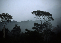
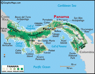
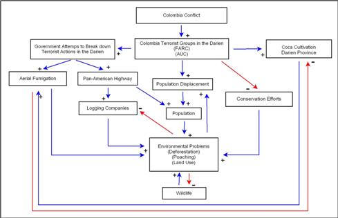
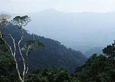
This case study demonstrates how the Colombian Civil War has impacted neighboring countries. It specifically focuses on the effect the conflict has on the Darién Province in the south of Panama, which is comprised of mainly dense tropical forest. Since the mid-1990s Colombian paramilitaries have crossed the border into Panama in pursuit of FARC guerillas. As a result, the region is now recognized as one of the most dangerous places in the world due to the increase in violent conflict and threat of possible kidnappings. As violence has increased, conservationists have been kept from doing their job in the region, which holds a national park (named a Biosphere Reserve in 1981), and RAMSAR protected wetlands. Now, excessive deforestation, poaching and overuse of land threaten the fragile ecosystems of the Darién.


Description:


Colombia’s Civil War:

Civil War has raged through Colombia for more than a century. From 1824 through 1950 the conflict was dominated by a political fight between the Liberals and the Conservatives. For more than 100 years these two parties fought for Colombian rule leading the country into extreme poverty. By the 1960s liberal peasant workers, displeased with the country’s conditions, organized into Marxist guerilla movements; namely The Revolutionary Armed Forces of Colombia (FARC) and The United Self-Defense Forces of Colombia (AUC).[1]

Since then, the government, whether Liberal or Conservative, have been fighting these guerilla forces by attempting to break down their means of financing; i.e. the illegal drug trade. During the ‘Coca Boom’ in the 1970s, guerilla movements cooperated with drug lords, and fought on the same front against the government. However, as drug lords gained wealth they bought out land for large cattle ranches, which often came under attack by the guerilla troops. Consequently, since the 1970s the conflict has evolved into a drug war between right-wing paramilitary groups and left-wing guerilla organization.[2]

In the past ten years, the Colombian conflict has impacted neighboring countries. This is especially apparent in Panama where FARC have kept a stronghold in the Darién Province without much Panamanian intervention. From 1995-1997 only two incidences of tension between Panamanian police forces and guerilla troops have been reported. Both times the police came face-to-face with guerilla forces of up to 35 men, yet the incidents resulted in no violence.[3] This is a clear sign that the government is trying to underplay the presence of guerilla troops in the region. Yet, due to the increased flow of refugees from Colombian and Panamanian border cities as well as violent attacks by Colombian paramilitary groups, the government can no longer turn a blind eye to the region.

Refugee Movement and Indigenous Populations:

The conflict in the Northern regions of Colombia has put extreme pressure on the local populations forcing them to flee their homes. The area has been chosen for a possible inter-oceanic canal from the Pacific Ocean to the Caribbean Sea, it holds vast tracts of usable woodlands, and has a wealth of biodiversity and mineral deposit. These, combined, have made the area of strategic interest to paramilitary troops, and thereby fueled incursions.[4]

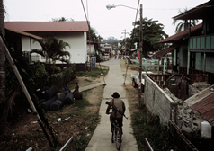
The first refugees from Colombia arrived in Panama in 1996 where some 400 farmers and their families fled into the Darién region.[4] At the turn of the decade refugee arrival decreased, but as the conflict intensified in both Colombia and Panama the number of displaced persons has once again picked up since 2002.[5] The arriving immigrants cause an increase in the population of the Darién province, and along with the constant movement of people, these two factors have put pressure on the areas natural resources.

Certainly, as a population accumulates some environmental damage is inevitable. However, often the damage is assessed to be indirectly caused by lacking help from relief organizations along with flawed government policies.[6] For instance, in Panama refugees have frequently been declined entrance or been deported. Between 1996 and 1997 alone some 500 refugees was send back to Colombia by the Panamanian government.[4] However, due to pressure from the international community, especially the United Nations High Commissioner for Refugees (UNHCR), Panama now accepts refugees, but neglect to assist them with their basic needs.[7] Unfortunately, such policies may aggravate the environmental impact since this lack of basic goods forces refugees to seek it out in their surrounding area.

Colombian refugees do not find peace in Panama. By 1997 Colombian paramilitary groups entered the Darién in pursuit of guerilla troops and guerilla sympathizers. In March 1997 shortly after an attack on FARC’s ‘Force 57,’ which pushed thousands of Colombians to flee to Panama, the AUC attacked two Panamanian villages resulting in seven fatalities; three in the village of Titina and four in the village of La Bonga.[7] In La Bonga more than 150 paramilitary soldiers threatened to kill everyone who cooperated with guerilla forces. One survivor, Juan Madrid Oquendo, a 74-year old campesino, explained how his friend was brutally shot three times in the head while he and three others lay on the ground with their hands tied on their back. After the attack more than 250 people fled to Puerto Obaldia with no plans of returning home any time soon due to fears of retaliation.[3]

Attacks, namely in the shape of rape and robberies continued to occur during 1997 and 1998.[7] Indeed, Panama has stepped up the security in the area. In September 1999 the Panamanian government deployed 1500 additional troops from its national police force adding to the already 1500 stationed there.[8] Yet, since the country has no standing army, and the police force stationed in the Darién is outnumbered and out-gunned by the insurgents, little is done to prevent violent attacks on Panamanian cities.[9] In October 2000 an attack on the village of Nazaret took the life of a 12-year-old girl and further injured 12 other Panamanian citizens.[9]

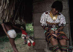
The refugees, many of which come from indigenous tribes that have occupied the area for centuries, now find themselves in a gridlock between paramilitary troops and guerilla forces. These tribes do not consider themselves Colombians nor Panamanians, but are border populations occupying both the Darién in Panama and the Chocó province of Colombia. In the Darién three indigenous tribes (the Kuna, the Embera-Wounaan, and the Afro-Darién) combined make up a population of 60,000 people.[10] As the conflict move closer and other populations move in on their land, their traditional livelihoods have been increasingly threatened. The United Nations High Commissioner for refugees has repeatedly expressed concern for the future of indigenous peoples' livelihoods. Due to the close link between their cultural traditions and ancestral lands, forced displacement has proven exceedingly difficult for many indigenous communities to handle. According to the UNHCR, many small tribes are in risk of disappearing due to their widespread displacement.[11]

In 2003, villages inhabited by the Kuna tribe people were attacked by Colombian paramilitaries. In the attack four indigenous community leaders were killed and three foreign journalists kidnapped.[12] Overall, about 500 Kuna have been displaced and are now living as Internally Displaced Persons (IDPs) in Boca de Cupe.[10] Due to the lack of attention by the Panamanian government, some indigenous groups are preparing to take action. In the San Blas Archipelago, Kuna tribesmen have been establishing their own self-defense forces to protect their villages.[3]

International Intervention and Environmental Impact:

After the Panamanian government agreed to let the UNHCR enter the region in 1997 to monitor refugees, they have set up a field office in the Yaviza.[13] In Panama, the UNHCR provides both legal and basic humanitarian assistance to displaced indigenous tribes and throughout the year a UNHCR staff member stay in the region to provide emergency relief.[11]

The United States (U.S.) has been intertwined in the Panamanian region for almost a decade since the construction of the Panama Canal. However, after the U.S. turned over the full operation of the Canal to the Panamanian government in December 1999, U.S. troops have left Panama.[7] Some argue that due to American plans of breaking down the international drug trade, which has become highly present in the Darién, U.S. troops disguised as drug-fighters are training, paying and commanding Colombian paramilitaries. Nevertheless, whether if these arguments are true, are still unfounded.[7] It is certain that a large sum of the $1.3 billion the U.S. are contributing to Plan Colombia goes to support the Colombian army fighting guerilla troops.[9] Undeniably, this may only make the conflict worse. To deal with the violence, the question at this point remains if the U.S. should change their current policies in the region by re-stationing troops to protect the indigenous population as well as the Colombian refugees.

While much focus have been put on the violence surrounding the Colombian conflict in the past, little attention have been paid to the impact this conflict may have on the natural environment in which it occurs. Indeed, researchers and scholars alike have mentioned the impact of the coca trade on the environment, as well as the continued terrorism of oil and gas pipelines in Colombia (See ‘Cocaine’ and ‘Colomoil’ cases).

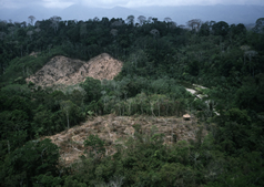
However, as the conflict in Colombia pushes more people to flee into the Darién, the fragile environment of this significant piece of tropical rainforest is threatened due to overuse of land and the possibility of increased infrastructure to support the rising population.

The U.S. Agency for International Development (USAID) as well as the Inter-American Development Bank (IADB) both provides development assistance to the region. A three-year six-million-dollar development program by USAID is aimed at increasing economic opportunities, including construction of small infrastructure and the promotion of ecotourism and improved agricultural procedures.[14] In addition, an $88 million sustainable development program supported by the Inter-American Development Bank (IDB) is aimed to provide additional infrastructure particularly roads in some of the densest parts of the region.[9] However, before such plans can be undertaken it is vital that sufficient Environmental Impact Assessments (EIAs) are conducted to fully protect the fragile ecosystems of the Darién. This may be difficult since the continuing conflict pose great dangers to environmental scientists and geographers who would carry out the assessments. Though, if completed with the appropriate EIAs to minimize environmental impact as much as possible, both of these measures may indeed improve the livelihoods of the local populations as well as open up the area to small conservation groups. (Please see the ‘Environmental Aspect’ Section below for details on the environmental impact).


Duration: [1996-Now]


The armed conflict in Colombia has been ongoing since 1964, but it has only been felt in neighboring countries in this past decade. As stated above, Panama felt this impact in 1997 when the first paramilitary groups entered the Darién Province in pursuit of FARC soldiers


Location:


Continent: North America

Region: Southern North America

Country: Panama


Actors:


The Revolutionary Armed Forces of Colombia (FARC):
The United Self-Defense Forces of Colombia (AUC)
Panamanian Government
Colombian Government
United States
Embera-Wounaan Tribe
Kuna Tribe
Afro-Darién Tribe


ENVIRONMENTAL ASPECT


Type of Environmental Problem: [Defor]


Deforestation:

In the Darién Province the presence of outlaws has, for centuries, had both negative and positive impacts on the natural environment. On one hand, since the region has been left untouched by the government for years, the forest has been allowed to flourish creating an ideal habitat for endemic species. On the other hand, however, the recent spillover of the Colombian conflict has set a new stage for the Darién that involves excessive deforestation and poaching; both of which significantly threaten the fragile ecosystems and biodiversity.

In recent years, environmentalists have been specifically concerned with the level of deforestation that occurs. At Yaviza, on both sides of the Pan-American Highway, excessive clearing of forest is seen for miles.[15] Along this stretch the level to which deforestation occurs is fairly simple to assess, and possibly control due to easy access. In contrast, it is the deforestation that occurs inside the forest including inside the Darién National Park that worries environmentalists. In these places, conservationists have only a vague idea of the level of deforestation that takes place since their assessments are based on satellite images not always showing the true picture. In recent years, due to limited access to the area, and the threat from guerilla warriors and paramilitaries, conservationists have been kept from doing their jobs.[16] It is only people who have traveled into the depths of the forest as well as locals who can give a real account of the environmental deterioration in the region. Ben Ryder Howe gives one of the best accounts of the deforestation kept secret in the National Park as he writes:


A low ridge signals our entrance to the Tuira Valley, and suddenly below us lies the landscape that the police so determinedly tried to shield from our eyes—the area revealed by the satellite images as a minuscule yet potentially catastrophic fracture in the otherwise perfect seal of the Gap.


To be fair, it hasn't been turned into a wasteland. More than a few trees remain. Here and there, in fact, it appears that the ecosystem is already on its way to recovery. But one would never describe this landscape as "forested." On the contrary, it appears indiscriminately and brutally cut, and in many places burned. Moreover, much of the destruction looks fresh—new fires burn below as we fly over.

                                                                                                    ~ Ben Ryder Howe, 2004 ~

Additionally, agriculture has taken a great toll on the area as well, and has been severely amplified due to the increase in the population. With the influx of immigrants from Colombia, the region population increases with about 5% annually. Most of the current population as well as the arriving migrants, in the Darién live in poverty thus relying on traditional forms of agriculture such as slash and burn; a technique used to clear forest for agricultural purposes.[17] Consistent slash and burn often leads to excessive deforestation, which in turn threatens the highly endemic biodiversity of the Darién.[16] One of the main crops in the area is sugar cane, which is known as a threat to primary forest, due to the agricultural practices used by sugar cane farmers. For example, when soil is exhausted farmers tend to move to a new slice of land, using slash and burn practices to clear the area. According to the UN, slash and burn significantly depletes the soil and can damage the jungle’s capacity to renew itself.[18] With the rising population and minimal assistance from Panama and the international community, such farming practices may continue at an increasing rate.

With the strong presence of the FARC it is assessed, by the U.S. Department of Drug Enforcement (DOE) that coca cultivation has increased in the area.[19] The use of land for coca plants can have an extreme impact on the environment. Even though it is difficult to asses the full impact, it is certain that deforestation as well as water pollution occurs.[20] Often coca growers locate their farms in remote tropical forests, which make the Darién region a viable location for future cultivation. Excessive deforestation from coca cultivation is mainly due to the low fertility of tropical soil, thus land is often being used for only two to three seasons and then abandoned for new land deeper inside the forest. Additionally, intensive farming practices associated with coca cultivation usually depletes the land even further causing increased erosion and downstream siltation.[20] Historical studies of coca cultivation in the Andean region shows that more than 2.4 million hectares of fragile tropical forest have been destroyed.[20] With that in mind, it is no wonder that conservationist worry about an increase in coca production. Not only due to the direct impact coca plantations has on the environment, but also due to the possible aerial fumigation of coca cultivated areas (Please see Environment and Conflict Link Dynamics below for further explanation).


Poaching Activities:

While deforestation poses one threat to biodiversity, poaching poses another. Amongst the species you will find the Darién region, are several threatened to go instinct such as the harpy eagle the jaguar, the wild dog, the tapir, and five species of macaw, the oncilla, the bush dog, the capybara, ñeques, and white-lipped peccaries [17]. Poaching is a common source of revenue for the illegal immigrants who cross the border from Colombia into the Darién. At many of the restaurants in Yaviza, turtle eggs, for instance, is frequently sold as an expensive, yet illegal delicacy.[16] However, poaching activities are not only associated with immigrants, but is also a common practice by the Embera-Wounaan populations who consider much of the National Park their homeland and traditional hunting grounds. During the 1990s conservationist groups in the Central American region tried to come to an agreement on poaching with the indigenous groups within the National Park.[21]


Type of Habitat: [Tropical]


The Darién Province makes up about 22.2 percent of Panama and covers an area of 15.458 sq. km.[15] It is one of the last pristine tropical jungles in the Western Hemisphere, and is one of the most biological diverse areas in Central America.[18] The park, as well as surrounding Darién, comprises a rich variety of habitats including sandy beaches, rocky coasts, mangroves, swamps and lowlands.[22] The entire province runs east across the border to Colombia from the Gulf of San Miguel to the territory of San Blas. The Eastern part contains the densest tropical rain forest and the famous Darién National Park. The Darién National Park, which has been considered protected since 1972, was established as a National Park by presidential decree in 1980. In 1981 it was inscribed as a World Heritage Site and officially recognized as a Biosphere Reserve.[23] The Darién's dense landscape is replenished by the Chucunaque and Tuira Rivers, two of the most important rivers in the southern region of Panama.[15]

The Biosphere reserve is home to marine habitats, riverine cativo forests, freshwater wetlands, tropical rainforest and elfin cloud forest. As one of the largest protected forests in Panama, the National Park holds one of the richest ecosystems in the American Tropics, and is considered an ideal habitat for species in peril.[17]


Act and Harm Sites: [Indirect, Nation A impacts Nation A]


Yaviza and Darién National Park (See map below).

map showing areas


CONFLICT ASPECT


Type of Conflict: [Interstate]


Due to the involvement of international actors, the Colombian civil war has turned into an issue of international concern. While the more than 50-year-old conflict has been fought mainly by Colombian paramilitaries and guerilla forces such as FARC, the U.S. have maintained a great presence in the region due to the persistent drug and arms trade, which fuels insurgencies. Even though U.S. troops have pulled out of Panama, political and military funding continues to flow between the U.S. and the Colombia as well as Panama. As mentioned above, in 2000 the U.S. government alone pledged $1.3 billion through Plan Colombia, which is meant to “achieve democracy and economic prosperity.”[24] So far, the U.S. has allegedly not been involved in any direct warfare in the region, though some locals believe that U.S. troops have been found to train paramilitary troops within the Darién province (see ‘Description’ above).

Additionally, due to the spillover of the conflict into neighboring countries, these are now forced to take action. This has been difficult for Panama since the country has no standing army, and the police force stationed in the Darién is outnumbered by the insurgents. As a result, little is done to prevent violent attacks on Panamanian cities.[9] At the moment, about 2000 Panamanian police forces occupy the area, but have been unable to do much since the FARC is better armed. This was particularly proven when the Panamanian police forces in 2000 recovered 271 AK-47 assault riffles, two high-caliber machine guns, 176 grenades, and almost 100 000 rounds of ammunition.[9] It is important to note, though, that the Colombian conflict for the most part continues to play out inside Colombia’s borders. Yet, this should not deter the international community from taking action in the area to protect the current population of refugees and indigenous tribes (Kuna, Embera, and Wounaan).


Level of Conflict: [Low]


The conflict level is set at low due to little activity in the region in the past year or so. This, however, does not necessarily indicate that the conflict is weakening. The conflict in the Darién is still persistent, but seems to simply receive less attention in the news than it did in the late 1990s and early 2000s. The current danger in the area can be assumed by the fact that the U.S. Department of State in April this year (2006) discouraged all travel to the Darién province including the National Park as well privately owned nature reserves and tourist resorts.[26]


Fatality Level of Dispute (military and civilian fatalities): [Low] <200


It is difficult to accurately assess the death toll in the Darién province, mainly because it is part of a larger region-wide conflict. Due to its connection to the Colombian civil war, death toll numbers are often included in Colombian datasets. In Colombia the number of fatalities from 1996 to 2005 was 10,715 people.[25] The best estimate of data for the Darién region can be obtained by looking at statistics from the Chocó province in Colombia, which borders up to the Darién.

In the Chocó region 142 to 332 people were victims of human rights violations, 108 to 194 were victims of serious violations such as rape and beatings, and 1 to 28 were victims of social or political persecution.[24] The reported numbers of people in the Darién region subject to the violent conflict match these numbers very closely; particularly compared to the number of victims of political and social persecution. Most reported fatalities in the Darién Region are civil, and caused by both Colombian paramilitary groups and guerilla warriors. In 2004 four religious and spiritual Kuna leaders were massacred by rightwing paramilitaries who accused them of being guerilla sympathizers,[10] and in March this year FARC assassinated an indigenous leader in the Union Wounaan Community. These attacks are only a few of many. It appears that several attacks are being kept hidden from the international community since, “The government does not want people to know what is going on;” as claimed by a senior park ranger who lost his father in a FARC attack in 2003.[26] Indigenous tribes (Kuna, Embera, and Wounaan) as well as Colombian immigrants fear daily the incursions by warring groups, which have resulted in entire villages being left vacant.[16] Notably, the secrecy surrounding these incidents may be due to strong objections by the Panamanian government and public to possible U.S. military intervention.


ENVIRONMENT AND CONFLICT OVERLAP


Environment-Conflict Link and Dynamics: [Indirect]


Conflict-Environment Diagram

As is obvious from the figure above the Colombian conflict is the main vehicle driving the Darién conflict as well as current, and possibly future, environmental problems in the area. On one side of the diagram Colombia militia groups have extended their presence into the area in order to seek refuge and reload supplies (as discussed earlier). As a result, the link between environmental destruction and the Darién conflict is not a direct one; rather it is indirect since it is the presence of the conflict that prevents conservationists from doing their jobs. In the 1990s conservation programs were significantly scaled back due to the increase in violence and kidnappings. Since then poachers, farmers in search of land, refugees, and small-scale timber companies, have overrun the region.[18] If these practices are kept unchecked, the vast ecosystems, which includes some of the most unique biodiversity found anywhere in the world, may be severely threatened.

On the other side of the diagram, the interest of the U.S. and Colombia to eradicate the drug trade by opening up the area to development and breaking apart terrorist funding opportunities, has enhanced the possibility of resuming construction of the Pan-American Highway, as well as aerial fumigation to eliminate coca crops. Both of these may cause considerable environmental damage and have thus been of major concern to conservationists (see 'Level of Strategic Interest' for further explanation).

A third pathway to environmental deterioration is through the displacement of Colombians that seek refuge across the Panamanian border. Currently the United Nations High Commissioner for Refugees has, on record, about 1900 refugees, asylum seekers, and others of concern in Panama.[27] This number may nevertheless be obsolete since it is believed that the number of people moving along the border is much higher than official reports indicate.[5]

Data on the impact of refugees is incomplete. However, it is certain that when a crowd of people settle in an area, some environmental damage will occur. It has been noted that, “the appearance of Colombian refugees places heavy demands on Panama’s resources.”[28] Also, as admitted by one human-right activist, refugees in the national park are often amongst those burning forest. During the dry season it has been reported that, “the smoke coming from the park is tremendous.”[16] Often, such environmental impacts could be avoided if relief organizations as well as the Panamanian government cooperate to provide the refugees with their basic necessities. Nevertheless, as long as the conflict in the region intensifies, relief organization may experience limited access not only due to the high level of threat, but also due to inadequate infrastructure.


Level of Strategic Interest: [Regional]


The Darién province is of great geopolitical interest to international players as well as the actors involved in the current conflict. Situated on the border between war-torn Colombia and Panama, the area is close to the Panama Canal and has been known for its part in illegal drug trade. The International community fears that the intensifying spillover of the Columbian conflict into Panama may endanger the protection of the Canal. Especially since the U.S handed over control of the canal in 1999 and the Panamanian police force is ill equipped to handle any possible takeover by Colombian terrorist groups.[8] Indeed, the Panamanian government, the Colombian government as well as the U.S. are finding it in their best interest to break down the drug trade in the area thereby weakening terrorist groups by eliminating their source of funding.

The measures proposed by all three governments, however, are much in opposition to any sort of protection of the national parks both in Panama as well as Colombia. In early 2005 Colombian President Uribe proposed two anti-environmental measures. One was to open up the area by completing the Pan-American Highway through the Darién province in Panama and Chocó in Colombia. The 108 km stretch through these regions is the only break in the highway, which otherwise spans from Alaska to Argentina. The second was to begin aerial fumigation of national parks where coca production is believed to be under way.[29]


The Pan-American Highway:

Until the 1970s the Darién province was largely isolated from the rest of Panama. However, by the mid-1970s the Panamanian government had started to extend the Pan-American Highway into the area, and a couple of years later the road had reached the town of Yaviza at the heart of the region.[30] Since then the road has seen no progress partly due to the strong presence of Guerilla forces, but mostly due to the fear that foot and mouth disease may spread from Colombia to Northern America.[16] In 1991, however, the United States Department of Agriculture declared that foot and mouth disease no longer posed as a threat to North America, thereby leading way for a new discussion on the proposed road.[30]

Proponents of the highway argue that the road will finally link the Latin American countries with the North and thus signify a new partnership based on increased trade and cooperation. In addition, Uribe asserted that the road would provide the Colombian government with an opportunity to “exert stronger control over persons who act outside the law… and allow better control over arms, money, and drug smuggling.”[30]

In contrast, opponents fear that the road poses as a significant threat to the area’s endemic biodiversity. Not only due to the possibility in the increase of logging companies, but also due to a significant increase in the population as well as to the impact road construction has in general on an area. These concerns are well founded if one takes a look at the historic data from the area. After the completion of the Pan-American Highway in Yaviza, the population grew at an annual rate of 6.5%, which was more than twice the national average.[30] From 1950 to 2000 the population increased from 14,660 people to 48,530. Most of these migrants were Mestizo colonists from central Panama seeking out cultivatable land.[30] As a result of access to the Darién province, large-scale deforestation resulted in almost complete devastation of the Western part of the province, which now consists of mere shrub and grassland used for extensive cattle grazing.[30]

It is certain that the opponents’ worries regarding the future of the area are reasonable. However, it is also important to recognize, as noted earlier, that the proposed highway may increase access to the area for conservationists who will then be able to resume their jobs protecting the forest.


Drug Trade and Increasing Coca Production.

For decades the Darién Province has been a prime area for drug smuggling, and in recent years it is suspected that coca cultivation is occurring as well. In 2001 the U.S. Drug Enforcement Agency reported that drug trafficking in the Darién province is increasing and small-scale coca cultivation has resumed and is ‘apparently’ expanding. The same report also posited alleged increases in underground laboratory activities. Nevertheless, except for the expansion of the drug-trade, none of these assessments have been verified.[19] Still, due to the possibility of coca cultivation, the area may be under a significant threat.

The involvement of the U.S. in Colombia’s war against drug trade does not make the situation much better. Through Plan Colombia, the U.S. government has made military training, helicopters, and surveillance available to Colombia in order to fight the drug trade [31]. Parts of Plan Columbia include aerial fumigation of large areas believed to hold coca plantations. Within a six-month time span alone the Colombian government sprayed 65,000 hectares of land in Colombia killing wildlife, contaminating water, and overall offsetting the ecological balance of most of these areas.[32] Considering the current belief that coca cultivation is increasing inside the Darién province, and the U.S and Colombian pressure to destroy crops through fumigation to cut off terrorist funding, Plan Colombia may thus indeed pose as a noteworthy threat to the environment.


Outcome of Dispute:
[In Progress]


Since peace negotiations between FARC and the Colombian government broke down in 2002, the conflict continues to ravage in Colombia as well as its neighboring countries. In the Darién Gap no violence has been detected in most recent years. However, the area is still considered unsafe due to the possible increase in kidnappings and killings.


RELATED INFORMATION AND SOURCES


Related ICE and TED Cases:


ICE Related Cases:

Cocaine: This case study explains the environmental impact caused by coca cultivation as well as details the Colombian conflict, which is largely fueled by coca production and trade.

Parana: Concerns the civil conflict between ranchers and local peasants in the Brazilian Amazon. The violent conflict rise when ranchers pursue land, which is owned by local peasants and indigenous populations.

Tupac: This case study concerns the conflict between (a) the rebel groups Tupac Amaru and Shining Path, and (b) the government in Peru. The conflict mainly takes place in Huellaga Valley, which is also central for the country’s coca production. In many instances, the conflict has deeply affected the indigenous populations of the valley causing fatalities.

Peruecwar: This case study details the dispute between Peru and Ecuador concerning 200,000 square kilometers of dense forest, which is located on the border between the two countries. Violent confrontations occurred in the mid-1940s where both countries mobilized their armies. Environmental deterioration is mainly due to cultivation of land for agriculture, as well as caused by mining for minerals such as uranium and gold.

TED Related Cases:

Pacifico: This case study holds information concerning the environmental damage caused by the proposed Plan Pacifico, which is meant to increase natural resource use in the Chocó region in Colombia as well as the Darién province in Panama.

Colcoca: Examines the link between coca trade and environmental impact in the Andes Mountains in Colombia. Specifically, it focuses on the difficulty of decreasing the environmental impact of cultivation due to the position of coca as a traditional drop as well as the influence and wealth of drug traders.


Relevant Websites and Literature:


1. Infoplease, “Colombia,” Almanacs, Infoplease.com, 2006, http://www.infoplease.com/ipa/A0107419.html (accessed: Oct. 31, 2006)

2. Garry Leech, “Fifty Years of Violence,” May 1999, Colombia Journal Online, http://www.colombiajournal.org/fiftyyearsofviolence.htm (accessed Sep. 19, 2006)

3. Jon Mitchell, “Colombia’s Civil War Arrives in Panama,” Apr 23, 1997, Tower Magazine, http://ourworld.compuserve.com/homepages/Harvey_Morris/ Darién.htm (accessed: Sep. 19, 2006)

4. Amnesty International, "Refugees: the Right to Escape from Death," Jun 1, 1997, Amnesty International: Panama and Colombia, http://web.amnesty.org/library/Index/ENGAMR440061997?open&of=ENG-PAN

5. Disasters: Preparedness and Mitigation in the Americas, “When the Displaced Cross Borders: The Case of Darién, Panama,” Jan 2003, No. 90, p1.

6. United Nations High Commissioner for Refugees (UNHCR), “Environmental Guidelines.” June 1996. Geneva. Can be accessed through http://www.unhcr.ch/environment; p. 5

7. The Economist, “Out by Panama’s Front Door, in Through the Back,” 10 January 1998, Vol. 348, No. 8050, p27-28.

8. Bruce Bagley, “Panama-Colombia border conflicts could threaten the canal,” 1999, CNN.Com, http://www.cnn.com/SPECIALS/1999/panama.canal/ stories/border (accessed: Oct. 1, 2006)

9. Andrew Bounds, “Panama Feels impact of Neighbour’s Conflict,” Financial Times, Oct 17, 2000, p5.

10. Seth Nickinson, “Colombia Joins PPP, Pushes for Extending Electrical Transmission Line Through Darién Protected Area by 2006,” Plan Puebla Panama News update, Sep. 2004

11. Marie-Hélène Verney. "Colombian Indigenous Leaders Flee to Panama After death Threats," may 19, 2006, UNHCR Web, http://www.unhcr.org/cgi-bin/texis/vtx/news/opendoc.htm?tbl=NEWS&id=446db7c84. (accessed: Dec 1, 2006)

12. United Nations High Commissioner of Refugees (UNHCR), “Panama: Villagers flee Colombian Paramilitary Attacks,” UNHCR Webpage, Jan 24 2003, UNHCR Briefing Notes, http://www.unhcr.org/cgi-bin/texis/vtx/print?tbl-NEWS&id=3e311f38b (accessed: Oct. 10, 2006)

13. United Nations High Commissioner of Refugees (UNHCR), "Colombia Situation Map," 1998, UNHCR Webpage, http://www.warchild.org/unhcr_IDP_columbia.pdf. (accessed: Dec. 1, 2006)

14. Eric Green, "USAID Funds Community Development Project in Panama's Darién Region: Project aims to create buffer against violence, narco-trafficking,” Feb 5, 2003, USAID Web, http://www.usaid.gov/press/releases/2003 /wf030205.html. (accessed: Dec. 1, 2006)

15. Republic of Panama.NET, “Darién” 2005-2006, Republic of Panama Visitor’s Guide, http://www.republicofpanama.net/Other_Provinces/Darién/Darién (accessed Oct. 1, 2006)

16. Ben Ryder Howe, “An Impossible Place to Be,” Outside Magazine Online, Sep 2004, http://outside.away.com/outside/features/200409/ panama_Darién_gap_1.html. (accessed: Oct. 2, 2006)

17. The Nature Conservancy, “Darian National Park, Panama,” 2001, Conserve Online, http://www.conserveonline.org/docs/2001/06 (accessed: Oct.1, 2006)

18. United Nations Television and Video, “Darién Forest: Sustainable Development,” Jun 23, 2004, Programme No. 864, http://www.un.org/webcast/864.pdf (accessed: Oct 2, 2006)

19. U.S Department of Drug Enforcement, “Drugs, Money, and Terror,” DEA Congressional Testimony, Apr 2, 2002, http://www.justice.gov/dea/pubs/cngrtest/ ct042402.html (accessed: Oct. 31, 2006)

20. U.S. Department of State, “The Andes Under Siege: Environmental Consequences of the Drug Trade,” July 2001, http://usinfo.state.gov/products/pubs/ archive/andes, (accessed: Oct. 30, 2006)

21. Pascal O Girot, “The Darién Gap between Colombia and Panama: Gap or Seal,” The Earth Council, San Jose, Costa Rica, From Concept to Design: Creating an International Environmental Ombudsman, March 1998; p27

22. ICWRP: The International Corporate Wetlands Restoration Partnership, “Project List for Natural World Heritage Sites with Significant Wetland, Marine, or Coral Reef Components,” http://www.icwrp.org/files/nh_sites_large-scale.pdf (accessed: Nov. 1, 2006)

23. United Nations Environment Program (UNEP), “Protected Areas and World Heritage: Darién National Park,” World Conservation Monitoring Center, July 1995, http://www.unep-wcmc.org/sites/wh/Darién.html (accessed: Nov. 1, 2006)

24. Amanda Romero-Medina, “International Displacement and Humanitarian Crisis,” Bogota, Colombia, May 2001

25. Department of Peace and Conflict Research, “Colombia: Detailed Information – Whole Country,” Uppsala University, http://www.pcr.uu.se/database/ conflictSummary.php?bcID=148 (accessed: Oct. 15, 2006)

26. Virtual Panama, “Darién Province,” Panama Provinces, 2006, http://www.unodc.org/unodc/bulletin/bull (accessed: Nov. 1, 2006)

27. Mark P. Sullivan, “Panama: Political and Economic Conditions and U.S. Relations,” CRS Report For Congress, May 20, 2005, http://www.ndu.edu/library/docs/crs/crs_rs30981_20may05.pdf (accessed: Oct. 15, 2006)

28. William W. Mendel, “Colombia’s Threats to Regional Security,” Military Review, May-June 2001, http://fmso.leavenworth.army.mil/documents/ colombia_threat/colombia_threat.htm (accessed: Oct. 10, 2006)

29. John Edwards Myer, “Colombia’s Biodiversity Up for Grabs,” June 2, 2005, IRC Americas Program Discussion Paper, America’s Program, International Relations Center, http://americas.irc-online.org/am/722 (accessed: Oct. 1, 2006)

30. Daniel Suman, “Globalization and Development: Using the Coastal Area of the Darién Region of Panama as a Case Study,” Occasional Papers on Globalization, Vol. 2, No. 5, 2005; 7

31. The Panama News, “Panama next Thailand?” Sep 7, 2000, http://www.hartford-hwp.com/archives/27c/484.html (accessed: Dec 1, 2006)

32. Embassy of Colombia - Washington, “Plan Colombia,” 2003, http://www.colombiaemb.org/opencms/opencms/plancolombia (accessed: Oct. 31, 2006)


Image Credits:

Special thank you to Alex Web and Magnum Photo graphs for supplying the wonderful pictures of the Darién Gap. To see more of Alex Web's work and other photographers with Magnum Photos click here.

Also, thank you to World Atlas for the graphic of Panama, to see more maps of the world designed by World Atlas click here.