
 I. CASE BACKGROUND
 |
 |
 |
 |
[1] |
1. Abstract
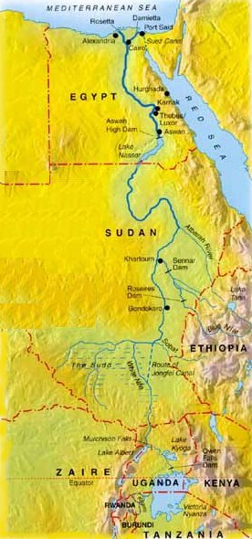 |
| The Nile river runs South to North in the North-Eastern half of Africa. [2] |
The Nile river provides nearly all of Egypt's fresh water for agriculture, industry and human consumption. All this water comes from 10 countries up-river from Lake Nassar. Yet, unlike other countries which lie at the base of river systems, Egypt's economic and military might allows it to wield enormous control over how countries up-stream use the Nile's water resources. However, the combination of population growth, economic development and climate change pose to reduce the available water per person in the region and shift the dynamics of power in the basin.
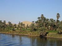 |
| Nile River from a cruise boat between Luxor and Aswan. [3] |
2. Description
As humanity begins to understand and address the issues of global climate change in the early 21st Century, one area of the world is both directly impacted by these changes and poignantly serves as a microcosm for the complex nature of the global problem. The Nile, the world's longest river,[10] embedded in the ethos of human history and birthplace of one of the world's first civilizations, is the giver of life to millions of humans living in its river basin. As the human population has grown in this region, people have made large-scale changes to the river, attempting to control nature to increase the river's usefulness to humanity.
However, every change has consequences, some understood, others not intended, and nowhere is this more clear than on the Nile, where history itself has been sacrificed for change.[11] When such a resource is under the guardianship of just one nation state it is easier to control the decision-making process and compensate disaffected parties for the negative consequences of change. The Nile basin, however, is in the trusteeship of 11 cultural and ethnically diverse African nation states,[12] four of which (Egypt, Sudan, Ethiopia, Uganda), have very critical national interests tied up in the river. Not unlike the players in global climate change, these nations vary in population size and growth, culture, GDP, and military might. Although global climate change may alter certain variables over time, it is human population growth, economic development and increases in the standard of living that are the largest contributing factors to the potential for conflict over the natural resources of the Nile.
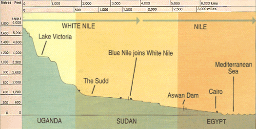 |
| This cross-section (not to scale) of the Nile River illustrates the heights from which the Nile originates. [4] |
The water which flows down the Nile proper originates from three major rivers, the White Nile, the Blue Nile and the River Atbara. The White Nile which flows steadily year-round, originates high in the mountains surrounding Lake Victoria, where rainfall in Rwanda, Burundi, Uganda, Kenya and Tanzania flow into the lake. Water then exits Lake Victoria through Uganda where the White Nile begins. Waters from the lakes of the Democratic Republic of the Congo and Uganda also contribute to the White Nile as it crosses over into southern Sudan. There the White Nile flows into a giant seasonal wetland surrounding the permanent Sudd swamps.[13] Tributaries which originate in Sudan as well as Ethiopia and the Central African Republic also help sustain this vast, mostly unspoiled, natural habitat. However, civil war and uncontrolled hunting, as well as the incomplete Jonglei canal, "at a width of 75 meters, a depth that varies between 4 to 8 meters, and a length of over 360 km, is also detrimental to wildlife in the area, acting as a large game trap."[14]
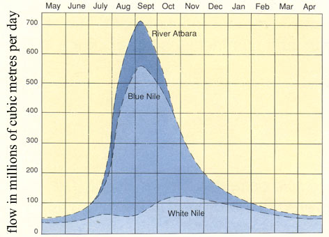 |
| As water from the Blue Nile and River Atbara are at their strongest in late August and early September the flow of water from the White Nile is restricted. [5] |
The White Nile joins the Blue Nile at Khartoum and becomes the Nile proper. The Blue Nile originates in the highlands of Ethiopia at Lake Tana and "is the chief headstream of the Nile by water volume."[15] It contributes the vast majority of water to the Nile between August and October, to the point where the volume of water rushing down from Ethiopia actually causes the White Nile to supply less water in August than July.[16]
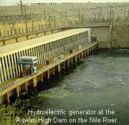 |
| As Egypt's population has grown and energy needs have increased, the Aswan High Dam has produced a smaller percentage of total power for Egypt year after year. [8] |
As the Nile flows through northern Sudan it is joined by the River Atbara, another tributary which originates in Ethiopia and Eritrea. This river adds to the seasonal flow between July and October.[17] The Nile then flows into Egypt's Lake Nassar, an artificial lake created by the construction of the Aswan High Dam.
Egypt's ability to control the annual flooding of the lower Nile river valley through the construction of dams and the building of irrigation systems has contributed greatly to Egypt's economic prosperity. Primarily built for flood control the dam also provides a great source of hydroelectric power. Unfortunately, the dam has also cut off the natural flow of nutrient-rich silt to the valley floor, which has resulted in Egyptian farmers having to use more irrigation systems and fertilizer to grow their crops.[18] Increased soil salination is a pressing environmental issue.[19] Before spilling into the Mediterranean Sea the Nile flows through Cairo and the giant Nile delta, a low-lying area vulnerable to sea-level changes.
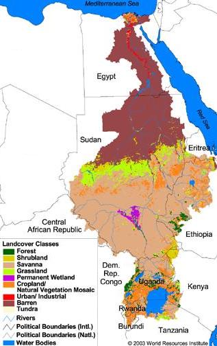 |
| The land cover throughout the Nile basin is as varied as it is vast. Climate change is predicted to alter the already fragile nature of this habitat. [21] |
The 2007 IPCC report on climate change informs us that "by 2020, between 75 and 250 million people are projected to be exposed to an increase of water stress due to climate change [in Africa]... Agricultural production, including access to food, in many African countries and regions is projected to be severely compromised by climate variability and change. The area suitable for agriculture, the length of growing seasons and yield potential, particularly along the margins of semi-arid and arid areas, are expected to decrease. This would further adversely affect food security and exacerbate malnutrition in the continent. In some countries, yields from rain-fed agriculture could be reduced by up to 50% by 2020."
"Local food supplies are projected to be negatively affected by decreasing fisheries resources in large lakes due to rising water temperatures, which may be exacerbated by continued over-fishing. Towards the end of the 21st century, projected sea-level rise will affect low-lying coastal areas with large populations. The cost of adaptation could amount to at least 5-10% of Gross Domestic Product (GDP)."
"New studies confirm that Africa is one of the most vulnerable continents to climate variability and change because of multiple stresses and low adaptive capacity. Some adaptation to current climate variability is taking place, however, this may be insufficient for future changes in climate."[20]
What specific impact climate change will have on various areas of the world is uncertain, but any change in the fragile environment of the Nile basin is bound to have an impact. Should rainfall increase the southern Nile, yet decrease in the northern Nile it might result balancing out any change. However, if temperatures do rise as predicted by IPCC, it could lead to more water evaporating along the Nile as it flows towards Egypt.
Pollution
"Water pollution in Egypt is increasing over time... The low level of sanitation service especially in rural areas (7% at most) makes nearby streams (either canals or drains) the perfect places for inhabitants to dispose their sewage. Many of the Industrial establishments do not comply with the law, dumping their wastewater untreated into surface water bodies as well as injecting it into groundwater. Excessive use of fertilizers and pesticides is another major source of water pollution despite the success in reducing the level of use of agro-chemicals during the past decade considerably. Extensive drainage reuse within the Nile delta and direct drainage spillage into the Nile River along the valley increase the effect of agricultural pollution as well."
"Current development plans show that more land will be reclaimed and more industrial areas will be constructed which will add more pollutants to the system if the effluents from these areas are not treated."[22]
Population Growth
While climate change and pollution are bound to have some effect on the availability of fresh water in the Nile basin, "the greatest single pressure has been caused by the very rapid growth of population."[6]
| The following table was constructed with data from the CIA World Factbook (Pop. Growth, '07 and '25 Populations, 2006 GNP)[24] and prior data from Conflict Management of Water Resources (Water Avail. '90 and '25).[25] | ||||||||||||||||||||||||||||||||||||||||||||||||
|
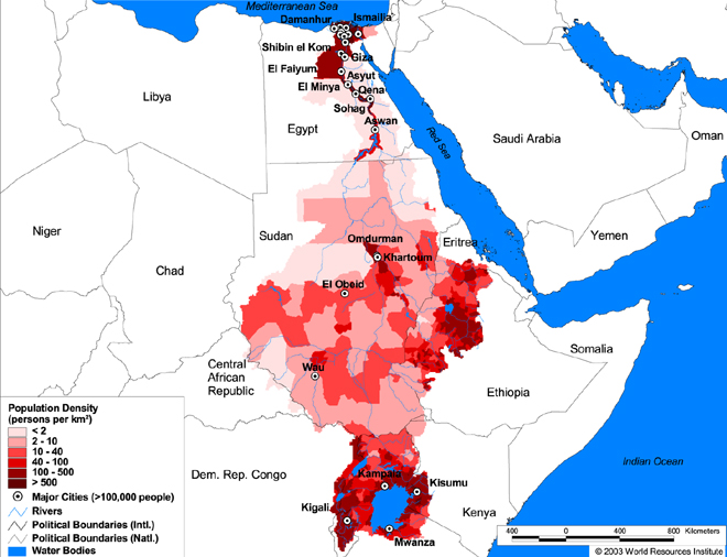 |
| The populations of humans are congregated along the Nile and its tributaries. [23] |
In the next 18 years the population of these four countries is expected to grow by nearly 50%. Although the population growth rate is lower than in the other countries, Egypt has a positive immigration rate, presumably because of its stable economic growth and high per capita income. Of these four countries Egypt is also projected to have the lowest per capita water availability in 2025,[26] nearly half of what it had in 1990. The other countries will not fair any better, as they continue to draw from the same limited natural resource. A shift in weather patterns, due to climate change or other atmospheric disturbances, may either have a slowing or accelerating effect on the use and availability of water, but it is unlikely to change the trend's momentum.
Conflict over Water
Boutros Boutros-Ghali once commented: "The next war in our region will be over the waters of the Nile, not politics."[27] His statement goes to underscore how important Egypt considers the waters of the Nile; Naturally it does, but Egypt also considers the access and supply of the Nile's water its undisputed right. Whether Egypt would attempt to destroy dams in other countries through the use of it's military is uncertain, however, Egypt does have much closer ties with powerful Western countries who would with high likelihood support Egypt in a water dispute.
But, we are not just talking about water for human sustenance, we are talking about the water used to drive an economy. "As a result of dependence on agriculture due [to the] lack of industry, 80% of water use in most Middle East countries is for irrigation purposes."[28] This may seem high, but it is generally in line with water use in industrialized nations. As the Nile basin nations continue to rely on growing their own crops in inhospitable climates, scarce water will continue to be a necessity, one over which people will fight. An increase in standard of living, in addition to population growth, will further drive the desire for more water.
By comparison, an average westerner in a single-family home uses approximately 286 cubic meters of water a year.[29] In the United States about a 3rd of available fresh water is used for irrigation and the production of food.[30]
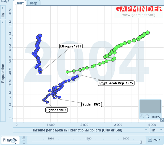 |
| This Gapminder graphic shows the population per country vs. GNP. Egypt has had a steady growth in GNP (income per capita in international dollars) as the population has grown. Sudan with a smaller population has had a similar growth path. Uganda has had a more difficult path because of disease and war. Ethiopia has had virtually no growth in GNP has its population has nearly doubled in 25 years. |
While the absolute minimum water required for survival by a human being is 36 cubic meters per year according to the World Bank,[31] the addition of water required for agriculture, industry and energy production increase this figure to "approximately 1000 cubic meters per person per year."[32]
Deadly diseases, such as Ebola or AIDS, as well as civil wars and large scale ethnic genocide may have a lowering impact on population growth rates, which ironically could delay large scale conflicts over the Nile's water resources. However, International efforts to stop diseases, wars and genocide in Africa, along with effective multi-national water management is likely to accelerate population growth and advance the timeline for inevitable conflicts over water.
 |
| This Gapminder graphic shows the population per country vs. life expectancy. |
3. Duration: 10 to 100 years
It is likely that conflict will begin around 2010, lasting indefinitely until a sustainable long-term multi-lateral environment management regime is established.
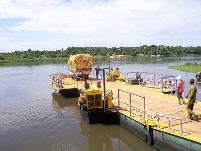 |
| A river boat crossing the Nile in Uganda near Murchison Falls National Park. [9] |
4. Location: Middle East in Africa Region
5. Actors: Egypt, Sudan
The main actors are Egypt and Sudan, but Ethiopia and Uganda play a role as well.
Conflict could include other nations in the Nile river basin including these 11 countries: Egypt, Sudan, Ethiopia, Eritrea, Uganda, Kenya, Democratic Republic of Congo, Tanzania, Rwanda, Central African Republic, and Burundi.
One very interesting aspect is that the Congo has vast water resources, a relatively small population per land mass and the GDP is an 8th of Egypt. The per capita water available in 1990 was 359,803 cubic meters, compared with Egypt's 1,123.[33]
II. Environment Aspects
6. Type of Environmental Problem: Many
7. Type of Habitat: Many
The Nile River basin is a very diverse environment. The river runs through Tropical Rain Forests, Savannahs, Marshlands, and Desert on its way to the Mediterranean Sea.
8. Act and Harm Sites:
| Location of Environmental Act |
Location of Environmental Harm |
|---|---|
|
Regional:
Population Growth and a change in climate will occur in all countries along the Nile river and its tributaries. |
Regional:
The negative affects of water shortages will be felt by varying countries to different degrees. Due to seasonal rains, floods and differences in availability to water during the year, some countries may face only temporary shortages during the year. As land becomes more arid over time, and the soil begins to suffer long-term, the environment impacts will be lasting. |
III. Conflict Aspects
9. Type of Conflict: War
10. Level of Conflict: Threat
11. Fatality Level of Dispute (military and civilian fatalities): 10,000 to 10 million
IV. Environment and Conflict Overlap
12. Environment-Conflict Link and Dynamics:
13. Level of Strategic Interest: Regional
Although conflict may arise between the eleven nations who have an interest in the Nile river's resources, an outbreak of conflict in this region is bound to pull in all regional nations and global players. Mass migrations could very well lead to more violence against various ethnic groups in surrounding countries and lead to a massive humanitarian crisis.
14. Outcome of Dispute: Compromise
Short-term: War - Unilateral actions taken by neighboring states which generate violent conflict.Long-term: Compromise - Likely outcome is the creation of a regional water and population management regime upheld by international treaties.

V. Related Information and Sources
15. Related ICE and TED Cases
- Tigris-Euphrates River Dispute (ICE)
- Nile River Dispute (ICE)
- Middle East Water Conflict: The Battle Over the Al-Disi Aquifer (ICE)
- Bio-Bio River Case, Chile (ICE)
- Serengeti Lions and Domestic Dogs (TED) -because of the impact population growth and canal construction has had on wildlife along the Nile.
- Israeli Water Use and Exports (TED)
16. Relevant Websites and Literature
[0] - Image of globe from NASA - Retrieved May 1, 2007, from http://apod.nasa.gov/apod/ap990131.html
[1] - Flags of Egypt, Sudan, Ethiopia and Uganda from the CIA World Factbook - Retrieved May 1, 2007, from https://www.cia.gov/cia/publications/factbook/
[2] - The Nile River by Michael Barron - Retrieved May 1, 2007, from http://www.mbarron.net/Nile/ (*)
[3] - Photo taken by Ian Sewell, Dec. 2004 - Retrieved May 1, 2007, from http://en.wikipedia.org/wiki/Image:Nile.jpg - License Creative Commons
[4] - The Nile River by Michael Barron - Retrieved May 1, 2007, from http://www.mbarron.net/Nile/ (*)
[5] - The Nile River by Michael Barron - Retrieved May 1, 2007, from http://www.mbarron.net/Nile/ (*)
[6] - Water Resources in the Middle East by Buelent Topkaya - Retrieved May 1, 2007, from http://www.akdeniz.edu.tr/muhfak/publications/gap.html
[8] - Egypt: Environmental Issues from US Dept. of Energy, EIA Country Analysis Briefs - Retrieved May 1, 2007, from http://www.eia.doe.gov/emeu/cabs/egypenv.html
[9] - Photo taken by Michael Shade, Fall 2006 - Retrieved May 1, 2007, from http://en.wikipedia.org/wiki/Image:Africa4_009.jpg - License Public Domain
[10] - Nile River. (2007). In Encyclopedia Britannica. Retrieved May 9, 2007, from Encyclopedia Britannica Online: http://www.britannica.com/eb/article-9373506
[11] - Construction of the Aswan High Dam "necessitated the relocation of the ancient Adu Simbel ruins." - Aswan High Dam. (2007). In Encyclopedia Britannica. Retrieved May 9, 2007, from Encyclopedia Britannica Online: http://www.britannica.com/eb/article-9356022
[12] - Review of entries for all 11 countries in the Nile River basin. In the 2007 CIA World Factbook. Retrieved May 1, 2007, from the CIA World Factbook Online: https://www.cia.gov/library/publications/the-world-factbook/
[13] - Saharan Flooded Grasslands - World Wildlife Fund. Retrieved May 2, 2007, from http://www.worldwildlife.org/wildworld/profiles/terrestrial/at/at0905_full.html
[14] - ibid
[15] - CIA World Factbook - Retrieved May 1, 2007, from https://www.cia.gov/cia/publications/factbook/
[16] - Referencing data from graph: The Nile River by Michael Barron - Retrieved May 1, 2007, from http://www.mbarron.net/Nile/ (*)
[17] - Referencing data from graph: The Nile River by Michael Barron - Retrieved May 1, 2007, from http://www.mbarron.net/Nile/ (*)
[18] - PBS Wonders of the World Databank: Aswan High Dam - PBS. Retrieved May 5, 2007, from http://www.pbs.org/wgbh/buildingbig/wonder/structure/aswan_high.html
[19] - CIA World Factbook - Retrieved May 1, 2007, from https://www.cia.gov/cia/publications/factbook/
[20] - IPCC Climate Change 2007: Impacts, Adaptation and Vulnerability Working Group II Contribution to the Intergovernmental Panel on Climate Change Fourth Assessment Report p. 9 - Retrieved May 1, 2007 from http://www.ipcc.ch/SPM13apr07.pdf
[21] - A10 Nile Watersheds of Africa - World Resources Institute. Retrieved May 1, 2007, from http://www.waterandnature.org/eatlas/html/af15.html (*)
[22] - Analysis of Nile water pollution control strategies: a case study using the decision support system for water quality management by Said, A, et. al - Sept. 1999 - Retrieved May 2, 2007, from http://www.wca-infonet.org/servlet/CDSServlet?status=ND0yODI4LjI1ODMzJjY9ZW4mMzM9ZG9jdW1lbnRzJjM3PWluZm8~
[23] - A10 Nile Watersheds of Africa - World Resources Institute. Retrieved May 1, 2007, from http://www.waterandnature.org/eatlas/html/af15.html (*)
[24] - CIA World Factbook - Retrieved May 1, 2007, from https://www.cia.gov/cia/publications/factbook/
[25] - Original graph found on Wikipedia via: M Chatteri et al. (2002) Conflict Management of Water Resources. Hampshire, Ashgate Publishing Ltd. p 146 - Retrieved May 1, 2007, from http://en.wikipedia.org/wiki/Hydropolitics_in_the_Nile_Basin
[26] - M Chatteri et al. (2002) Conflict Management of Water Resources. Hampshire, Ashgate Publishing Ltd. p 146
[27] - Quoted in Gleick, "Water and Conflict," p. 86, from Resource Wars, Michael T. Klare, p. 153.
[28] - Water Resources in the Middle East by Buelent Topkaya - Retrieved May 1, 2007, from http://www.akdeniz.edu.tr/muhfak/publications/gap.html
[29] - Water Consumption Calc., Used calculation on May 1, 2007 at http://www.csgnetwork.com/waterusagecalc.html
[30] - Water Use in the United State US National Atlas.gov - Retrieved May 1, 2007, from http://nationalatlas.gov/articles/water/a_wateruse.html
[31] - The World Bank, A Strategy for Managing Water in the Middle East and North Africa (Washington, D.C.: World Bank, 1994), p. 11. (Referenced via Resource Wars, Michael T. Klare, p.142)
[32] - From Peter H. Gleick, "Water and Conflict," International Security, vol. 18, no. 1 (Summer 1993), pp. 90, 100-01. Gleick derives this figure from Marlin Falkenmark, "Fresh Water--Time for a Modified Approach," Ambio, vol. 15, no. 4 (1986), pp. 194-200. as referenced in Resource Wars, by Michael T. Klare, p. 142
[33] - M Chatteri et al. (2002) Conflict Management of Water Resources. Hampshire, Ashgate Publishing Ltd. p 146 - Retrieved May 1, 2007, from Wikipedia http://en.wikipedia.org/wiki/Hydropolitics_in_the_Nile_Basin
Last updated: May 15th, 2007