
1. Abstract
Ethnic conflict climaxed in 1999 when a Guadalcanal youth rebel group Isatabu Freedom Movement (IFM) violently attacked habitats of Malaitan decent living in Honiara, the capital. Twenty thousand Malaitans were forced to migrate out of the capital. With the Solomon Island’s weak government, increasing population size, and decreasing habitable and arable due to sea level rise, increased ethnic conflict may be in the near future.
2. Description
Sea Level Changes
The IPCC predicts that in this century there will be between 18-70 cm sea level rise from ice melt and thermal expansion. In addition sea level rise an increase in intensity of cyclones in the Pacific region is also likely. Changes in runoff caused by increase in global temperature and disruptions in the hydrological cycle are likely increase in this area. Although much is unknown because of the variability of the climate, physical proof, such as an increase in erosion of the coasts and saltwater intrusions, is amounting (1).
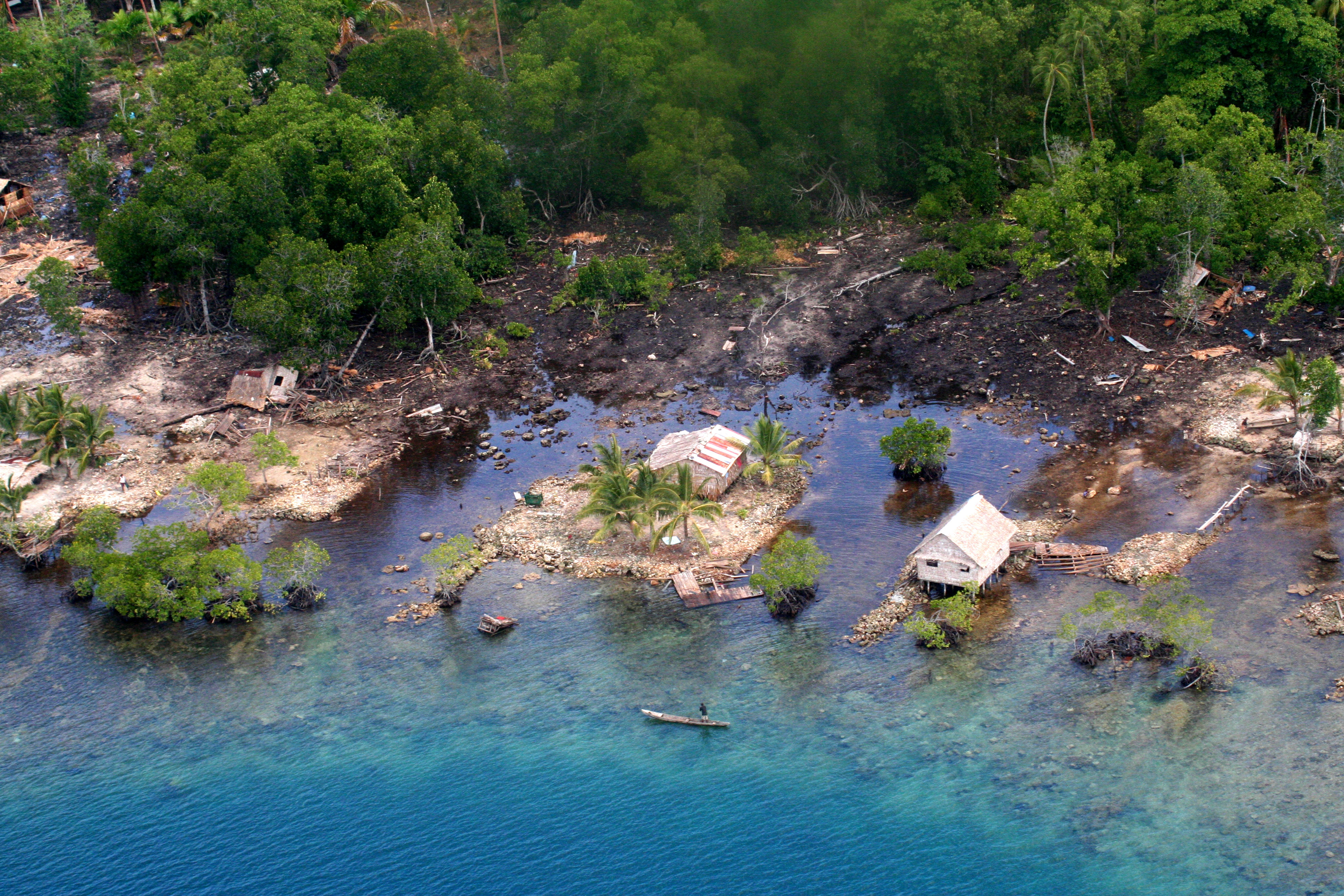 |
| Coastal erosion on the Island of Malaita. http://www.paxgaea.com/SolomonIslands.html |
Demographics
The people of the Solomon Islands, more specifically the islands Malaita and Guadalcanal, live mostly by subsistence farming. On the island Guadalcanal 75% of the natives live this way with only a small amount working higher paying jobs in the timber, gold mine, and palm oil industries. However, migrants from the island Malaita living in primarily the capital Honiara have a high rate of employment in the services sector working for the timber, gold mine, and palm oil industries (historical explanation, see conflict section) (2).
Starting in 1998 the Asian economic crisis spread to the Solomon Islands. There was a crash in the market for tropical timber that had reduced the Islands’ GDP by around 25%. This along with a deteriorating government and its police force split by ethnic rivalries, amounted to the creation of two warring youth militant groups the Isatabu Freedom Movement (IFM) and the Malaita Eagle Force (MEF). Ethnic violence sparked by long-term economic favoritism for the Malaita immigrants climaxed in 1999 when the IFM violently forced 20,000 Malaita immgrants from there homes in Honiara after the MEF captured Gwale supporter Prime Minister Bartholomew Ulufa'alu forcing him to resign. The ethnic violence resulted in around 500 deaths, thousands left homeless and the closing of gold mines and palm oil farms, which primarily employed Malaitans (4). The Gwales complained that the Malaitan immigrants were taking the increasingly rare service jobs and being allowed to own lands on Guadalcanal, taking away farming opportunities from native Gwales (3). The ethnic violence decreased in 2003 when the Regional Assistance Mission to the Solomon Islands (RAMSI), a multinational police force created by Australia, arrived on Guadalcanal to restore peace and to help rebuild institutions.
From 2003 to today ethnic violence has been waning and only surfaces when there is increased competition for employment or land.
IFM
The Isatabu Freedom Movement, also known as the Guadalcanal Liberation Front, Guadalcanal Revolutionary Army, and the Isatabu Freedom Fighters, was organized between March and October of 1998 and is comprised of mostly Gwale villagers from the south coast and the northern area of Honiara. It is estimated that IFM consists of 2,000 militants including many child soldiers. The IFM has no known leader and its mission is to simply drive out Malaitans from Guadalcanal, by migration or murder. The IFM controls rural Guadalcanal around the capital of Honiara. They are armed with old WWII rifles and hunting guns (3).
MEF
The Malaita Eagle Force was formed in response to the violence and displacement of the Malaitan people by IFM force. This group is much smaller at around 500 villagers recruited from angry displaced families and Malaitan police officers. There is no known leader as well. Since the coup in 2000, the Police Field Force and the Rapid Response Unit have joined with MEF and supplies its militants with weapons (3).
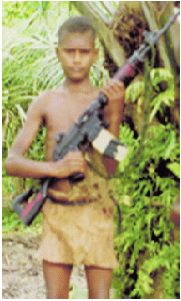
Picture: IFM child soldier, source Amnesty.org
|
Population Growth
Population growth for the Solomon Islands is already an issue. The total population size is exceeding half million and growing at a rate of 2.2%. The birth rate is high while the death rate is relatively low with the average life expectancy at 74 years. There are increasing numbers of forced migrations caused by large populations on small islands and the abuses to natural resources. Natural resources, such as fresh water and fertile soil, are becoming dangerously limited for a rapidly increasing population, and for families that live on subsistence farming their futures are looking dimmer everyday (2).
3. Duration: 1998-present
4. Location
| Continent: Asia |
Region: Southeast Asia |
Country: Solomon Islands |
Islands: Malaita and Guadalcanal |
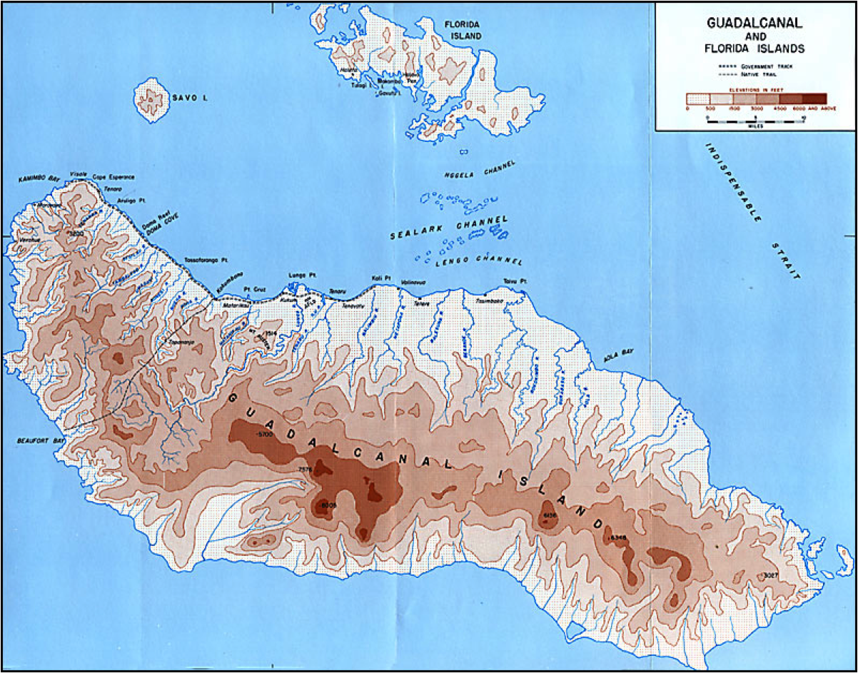 |
http://www.ibiblio.org/hyperwar/USA/USA-P-Guadalcanal/USA-P-Guadalcanal-2.html
Map showing the elevation of the Guadalcanal Island. Almost 50% of the island is below 50 meters and the coastal regions (including Honiara the capital) are vulnerable to sea level rise. This island experienced the most ethnic conflict, so an increase in sea level rise will decrease land mass along the coast and potentially cause ethnic conflict.
Second map is the map of Malaita: http://antbase.org/ants/africa/personal/solomons/sols10.html |
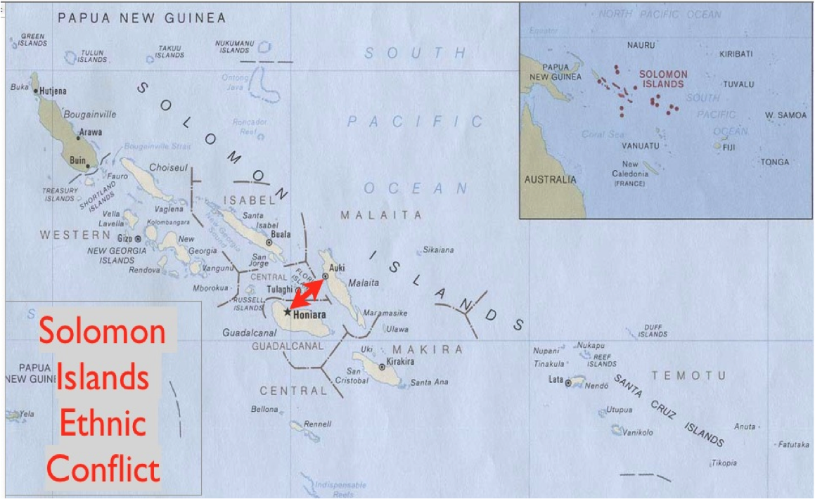 |
http://4.bp.blogspot.com/_x7xNgfhbbWo/TCNsXFeKM0I/AAAAAAAAAgo/gg1xsfM0yWo/s1600/Solomon4.jpg
Map showing the primary location of conflict. The red arrows show the migration path of Malaitans migrating to Honiara, a Gwales territory. Conflict was concentrated in the city regions. |
5. Actors
The Isatabu Freedom Movement (IFM), the Malaita Eagle Force (MEF), the Regional Assistance Mission to the Solomon Islands (RAMSI), the Solomon Islands Government.
6. Type of Environmental Problem
Climate Change
Sea level rise has already decreased the amount of arable and habitable land on the Islands of Malaita and Guadalcanal by 20+ centimeters. By 2100 the predicted sea lev
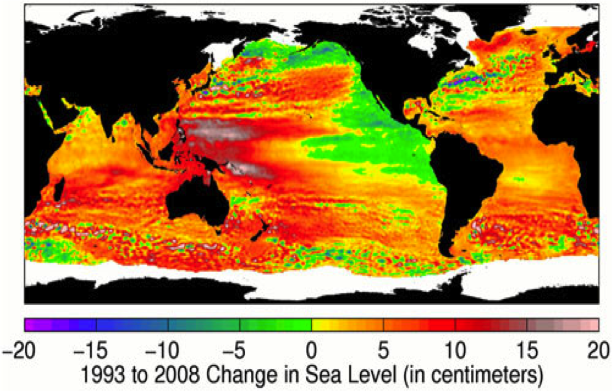 |
http://climatechangepsychology.blogspot.com/2010/03/peter-hogarth-skeptical-science-visual.html
Change in sea level around the world. Solomon Islands are located in an area that has experienced 20+ centimeter increase in sea level. |
el rise could be as high as 70 centimeters. Much of the Malaita and Gudalcanal coasts are below two feet of elevation, if not below sea level. Many islands are coral atolls and are likely to disappear within the century. This will also promote coastal erosion and saltwater intrusions further decreasing arable and habitable land (1,5).
Deforestation
The Solomon Islands’ government has issued permits for logging up to 4 million cubic meters per year when it is estimated that 325,000 is the amount of logging allowed in order to sustain the rain forests in the Solomon Islands. This massive amount of exploitation of the land is causing soil erosion polluting water supplies and decreasing nutrient rich soils for agriculture (6, 7).
Tsunamis
The most recent tsunami occurred on April 1, 2007 caused by a magnitude 8.1 earthquake along the Solomon Islands subduction zone. Thirteen people were killed by the tsunami and around 500 were left homeless. The wave was said to be between 10 and 16 feet high. This is a regular occurrence for the Solomon Islands as they rest on the ring of fire. Earthquakes have occurred in the years 1919, 1920, 1945, 1946, 1971, etc. are usually between the 7-8 magnitudes. These regular events have been adding instability to the islands(8,9).
 |
Location of the 2007 tsunami. http://walrus.wr.usgs.gov/tsunami/solomon07/ |
7. Type of Habitat: Tropical
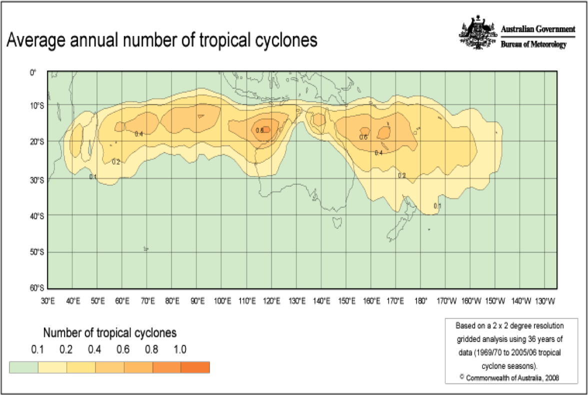 |
http://www.bom.gov.au/jsp/ncc/climate_averages/tropical-cyclones/index.jsp?period=all#what
Graph showing the average number of tropical cyclones within the past 36 years. The Solomon Islands are in an area of increased likelihood of tropical storms increasing the likelihood of erosion and saltwater intrusion.
http://www.bom.gov.au/cgi-bin/climate/change/global/trendmaps.cgi?map=global_t®ion=sh&season=0112&period=1970
Annual temperature rise since 1970. The Solomon Islands are located in an area that experienced on average a 0.10-0.30 rise in temperature, effecting sea level rise and cyclone intensity. |
8. Act and Harm Sites: All Solomon Islands, mainly coastal regions
9. Type of Conflict: Civil
History: British Colonization
In the pre-colonial Solomon Islands, tribal conflict between the early Malaitans and Gwales was less frequent. Divisions between the two ethnicities was less severe as many Malaitan genealogies today can be traced back to Guadalcanal indicating that Malaitan and Gwale marriages were acceptable, showing early cohesion between the groups.
International trade started in 1840 for the Solomon Islands, at which time the ethnic divisions began. About 9,000 Malaitans were recruited to be indentured servants in Queensland, Australia, while no known Gwales were recruited.
From 1896 to 1906 British colonization of the Solomon Islands negatively effected primarily the Gwales because by 1906 the British and the foreign company, Levers Pacific Plantation Limited, was in control of 90% of the fertile lands on Guadalcanal, the most fertile land on all of the Solomon Islands.
Injustices towards Gwales continued up to the Solomon Islands’ independence in 1978 and beyond. The capital, Honiara, located on the island of Guadalcanal was increasingly being inhabited by migrants (primarily Malaitans) coming to Guadalcanal for jobs. The growth of migrants on Guadalcanal was exacerbated by the foreign companies taking fertile lands in Guadalcanal for agriculture and palm oil, both hiring primarily Malaitans. The foreign fishing industries in Guadalcanal also hired Malaitans. In 1977 there were 400 Malaitan laborers living in Guadalcanal and by the year 2000 there were about 8,000 Malaitans working and living on Guadalcanal.
The British colonization and the influence of foreign companies, the plantation companies primarily, forced previously separated ethnicities into the same plantation communities. These communities, “Village Committees,” were created to support village-type law and order. Yet, these committees proportioned its ruling system as one representation from each tribe, of which most tribes were Malaitan. This disproportion caused misrepresentation of the native Gwales who were repeatedly losing their lands.
Whether it was British colonizers or foreign companies or different ethnic groups, the Gwales have lost most of their land, their opportunities for jobs, and their say in their communities (11).
Ethnic Violence: 1998-2003
Gwale bitterness towards Malaitan domination of the capital and political power over rural business became violent in 1998. Tensions between the Malaitan immigrants and native Gwales turned into ethnic violence with the creation of the Isatabu Freedom Movement (IFM) and the Malaitan Eagle Force (MEF). In October 1998 the armed IFM began threatening, killing, and chasing over 20,000 Malaitan immigrants from their homes to seek refuge on other islands or in Honiara. Also, 10,000 Gwales fled to remote areas within Guadalcanal to escape the violence. The IFM violence shut down the palm oil plantations and the gold mine, which were maintained by Malaitans and are two of the main exports for the Solomon Islands, causing widespread unemployment and poverty. In response to the violence and jobs loses the Malaitan Eagle Force was organized. This caused a one-sided conflict to become an ethnic war between the IFM and MEF (10).
In June of 1999 the Solomon Islands’ government, led by Prime Minister Ulufa’alu, sided with the Gwale natives and stated that the government would give compensation to indigenous Gwales in exchange for a peace agreement between the IFM and MEF. The IFM, however, disregarded these demands and the violence continued. The MEF retaliated against the government’s siding with the Gwales and its hesitation to give compensation and aid to the Malaitans, and in response led a coup d’�tat on the government on June 5, 2000 and forced Prime Minister Ulufa’alu to resign. This allowed the MEF to join with the Police Force and lead more violent attacks on Gwales (10).
Ethnic Killings
On July 10th 2000 in the National Referral Hospital in Honiara, three masked gunmen identified as members of MEF threatened the staff and broke down the doors to a room where two IFM members were recovering from gunshot wounds and shot and killed them at close range. These men were never found (3).
On June 12th 1999 IFM militants entered a plantation village housing Malaitans. After ordering all the Malaitans to leave, the IFM militants started brutally attacking fleeing Malaitans including stabbing and shooting whole families, children included. Most were injured and many died (3).
|
10. Level of Conflict: Medium
11. Fatality Level of Dispute (military and civilian fatalities): 500
12. Environment-Conflict Link and Dynamics:
Causal Diagram
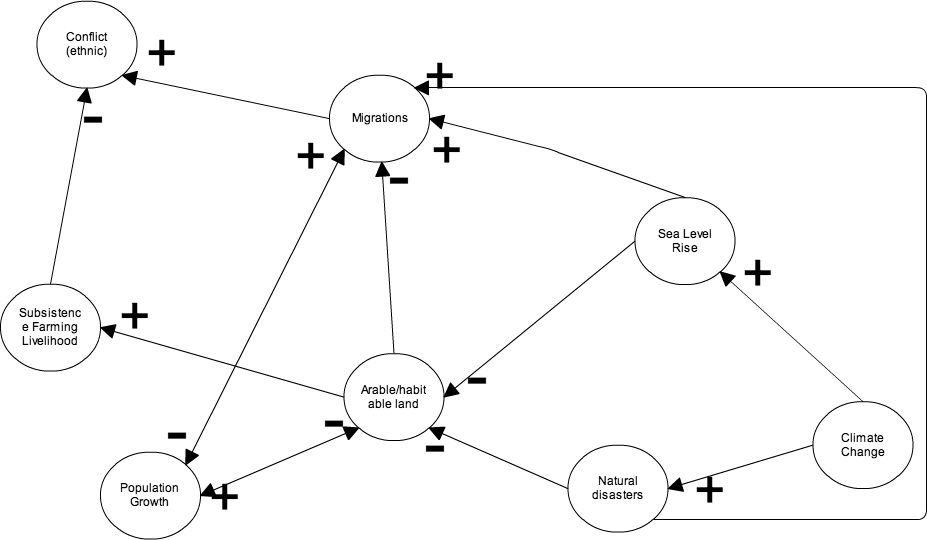
Climate change will potentially cause large changes in sea levels from the melting of polar ice and thermal expansion. In addition to present day catastrophic earthquakes and tsunamis, storms, such as cyclones, will increase in intensity. Both of these will decrease the land area of the Solomon Islands and also increase the saltwater intrusions into agricultural lands and water supplies.
 |
http://www.sprep.org/climate_change/pacc/pacc_news_detail.asp?id=915
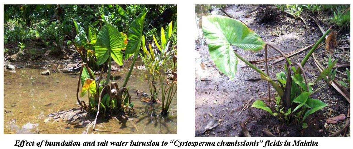
Picture showing the effects of saltwater intrusion into a Malaitan region. One of the many causes of migration. Saltwater intrusion will decrease plant production and even eliminate it in many regions. |
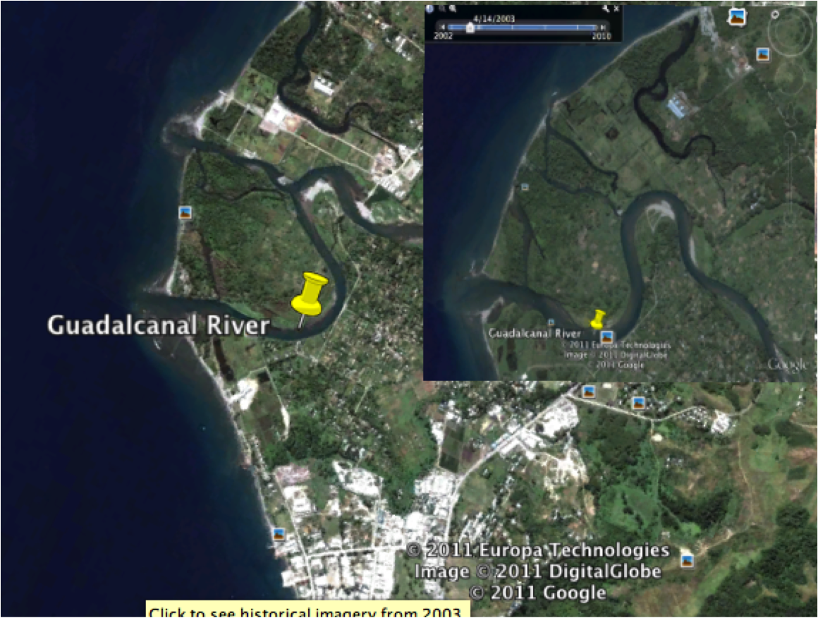 |
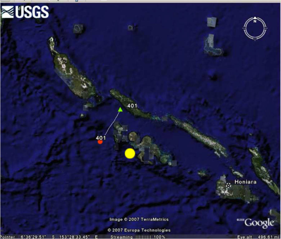
| Graph created in Google Earth showing in the top right corner the Guadalcanal River in 2003 and then in the left the Guadalcanal River in 2009. Saltwater intrusion and land erosion is seen as the river is increasing in tributaries and width. Land mass is decreasing with sea level rise. This river is close to the Capital Honiara. If this sea level rise and erosion is wide spread agricultural land and coastal cities will be affected and thousand of people will be forced to migrate. |
Sea level rise and natural disasters will have a direct effect by increasing migrations from areas such as the Malaitan dominated coastal capital, Honiara. While the land area is decreasing the population is growing increasing migrations and decreases available land. Eventually, decreased land area and migrations will decrease population growth, but the impact on reducing conflict may only be minimal. Force migrations and reduced land area will reduce their ability to survive because agriculture will be less viable. This will cause an increase in Malaitan-Gwale interactions and exacerbate completion for land and jobs. With Malaitans and Gwales migrating into each other’s territory and competing for land and resources conflict will be more likely.
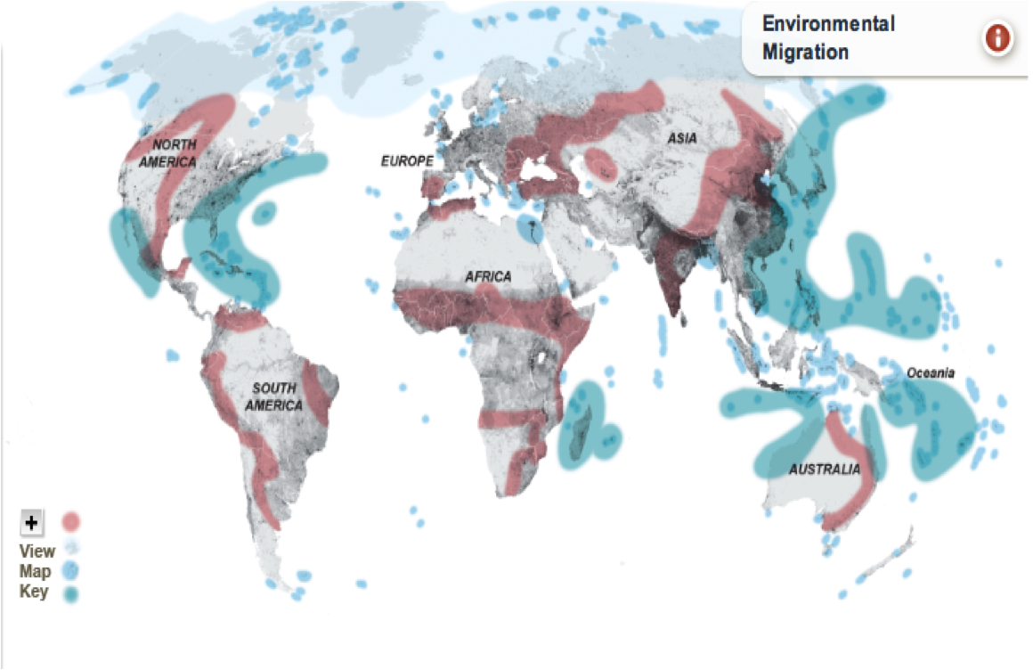 |
http://earthpulse.nationalgeographic.com/earthpulse/earthpulse-map
Graph showing the areas around the world vulnerable to desertification (red), ice melt (grey), storm surge and sea level rise (light blue), and hurricane/typhoon/cyclone intensity (dark blue/green). The Solomon Islands are in a region vulnerable to sea level rise and increase in tropical storms. This will increase the likelihood of forced migrations and cause conflict. |
13. Level of Strategic Interest: Regional
14. Outcome of Dispute:
In 2003, the new Prime Minister, Sir Allen Kemakeza, requested assistance from the countries of the Pacific region. On July 22, 2003, the Solomon Islands National Parliament passed the Facilitation of International Assistance Act allowing the Regional Assistance Mission to the Solomon Islands (RAMSI), funded and led by Australia and New Zealand, to enter the Solomon Islands and take action to restore law and order, rebuild the economy, and banish corruption from the government. This task force, comprised of soldiers, police officers and civilians from Australia, New Zealand, Fiji, Samoa, Papua New Guinea, and many others, arrived on July 24, 2003 and is still there today successfully working with the government and civilians to help restore peace to Guadalcanal. Only one Solomon Islander has been shot and killed by a RAMSI official for the entire residence of RAMSI. Since 2004 over 4,000 fire arms have been collected and ethnic violence has somewhat subsided in the areas around Honiara, but since much of the violence is happening in rural, remote villages around Guadalcanal the reach of RAMSI is limited and ethnic violence still continues today (12).
 |
| RAMSI. http://bild-art.de/kpress/index.php?option=com_content&task=view&id=134 |
The future looks grim for the people of the Solomon Islands. Hope lies with the failed government to step up and take action for adaptation and mitigation efforts. Also, RAMSI could help with adaptation efforts, but it need to expand in size to encompass all of the Solomon Islands. The communities living on reef atolls will need to move within the next 50 years, so the Solomon Islands needs to prepare for an increase in migrations from one island to another. Improved infrastructure, education on birth control and climate change, and foreign support would all be needed to ensure ethnic conflict and poverty do not take over the country in the future (13).
15. Related ICECases
Solomon Islands and Deforestation
Asian Tsunami and Thailand Religious Strife
Brazilian Migrations and Environmental Consequences
Maldives and Sea Level Rise
Spratly Islands Dispute
Abu Musa Island Dispute
16. Relevant Websites, Literature, and Sources
Case Study of Solomon Islands Peace and Conflict-related Development Analysis
(5)South Pacific Sea Level and Climate Monitering Project
Vulnerability of Island Countries in the South Pacific to Sea Level Rise and Climate Change
Implications of Climate Change for Armed Conflict
Climate Change and Conflict: Moving Passed the Impasse
Migration and Climate Change
Disasters and Forced Migration in the 21st Century
(11)SOLOMON ISLANDS: Ethnic conflict a legacy of imperialist exploitation
Solomon Islands Conflict
The view from beneath the waves: climate change in the Solomon Islands
Climate Change in Melanesia
(1)Small Islands: IPCC
(13)Climate change adaptation of the poor and vulnerable in small coastal Islands in the Pacific: Implications for poverty reduction
(10)Solomon Islands
Demography, Migration and Conflict in the Pacific
(6)U.S. Department of State: Solomon Islands
(2)CIA Factbook: Solomon Islands
(7)The Solomon Islands: Headed for Self-destruction?
(8)Preliminary Analysis of the April 2007 Solomon Islands Tsunami, Southwest Pacific Ocean
(9)Deadly Tsunami Sweeps Solomon Islands
Australian troops dispatched to Solomon Islands to suppress local population
Solomon Islands Conflict: Demands for Historical Rectification and Restorative Justice
(3)SOLOMON ISLANDS: A forgotten conflict
(12)Regional Assistance Mission to the Solomon Islands
(4)Database on Violence
Top Pictures:
Children
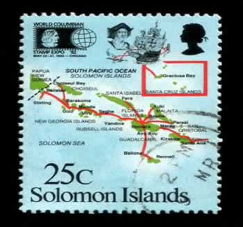
Stamp
Flag
©Jessica Roberts, July 2011
