ICE Case Studies |
Svalbard - Climate change, resources and ownership Maartje Tubbesing |
I.
Case Background |
|
|||||
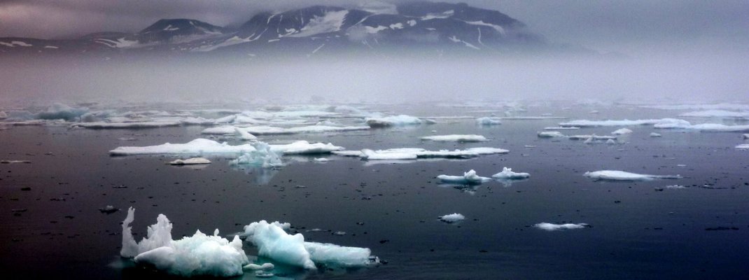
| Source: travelblog.org |
Svalbard is a barely inhabited group of island in the Barents Sea which has belonged to the Kingdom of Norway since 1920. It is governed by a unique set of rules - the Svalbard Treaty - which grants the non-discriminatory treatment of signatory states nationals, environmental protection and non-military use. This setup worked well for many decades and for an increasing number of signatories. However, prospects of large fossil fuel reserves in the region and the development of a comprehensive international law of the seas, which seeks to clarify the governance and ownership of the world's oceans, have put a spotlight on the weaknesses of the Svalbard regime. There exist different interpretations of the scope of the Svalbard regime which may increase in the light of climate change and better accessibility of oil and gas reserves in the Arctic Ocean. So far, the conflict is not much more than a diplomatic dispute. However, this could change as oil and gas explorations intensify.
Political Background:
The exact date of Svalbard’s discovery
is not known with certainty. Norwegians are believed to have visited
the archipelago between the 9th and the 14th centuries. What is known
is that in 1596 the Dutch Willem Barents (re)discovered the islands and
found large schools of whales in the region. Consequently, whalers
from several countries came to Svalbard for the whale hunt until in the
middle of the century, the whales had almost completely disappeared
from the region. Since Svalbard’s (re)discovery, the kingdom of
Denmark-Norway had laid claim on the islands but the end of the
Napoleonic Wars put an end to Denmark’s union with Norway. The status
of Svalbard remained unsettled; it was no-man’s-land and of no great
interest to any country until large coal deposits were found in the
area. Three international conferences on the status of Svalbard before
the First World War brought no clear settlement and it was only after
the War that Norway’s sovereignty over the islands was agreed. (Ostreng 1978, 3-4)
Svalbard has belonged to Norway since
the signature of the Svalbard Treaty (also known as the Spitsbergen
Treaty). It was signed at the Versailles Peace Conference in 1920, as
one piece of a puzzle of territorial treaties which aimed to end war
once and for all in Europe. The vision of a peaceful world was
destroyed less than 20 years later with the outbreak of the Second
World War. The Svalbard Treaty is one of the few agreements of
Versailles that survived these destructive years, as well as the Cold
War period. It enshrined the principle of “equal treatment” for the
signatory countries and made a peaceful coexistence of East and West in
the high north possible.
Norway’s annexation of Svalbard under the Svalbard Treaty was
accompanied by six fundamental principles, which modified Norway’s full
sovereignty in favour of the other signing parties. The result was a
unique model of ownership and access. (see the following section) (Wallis 2011, 5-6)
The original signatories of the
Svalbard Treaty were Norway, The United States of America, the United
Kingdom, Denmark, France, Italy, Japan, the Netherlands, and Sweden. (Numminen 2011, 8)
Soon after the conclusion of the Versailles Peace Conference, the
Norwegian government also sought negotiations with Germany and Russia,
who had been barred from it. Both countries had had a long historic
involvement in the archipelago and the “Norwegian authorities realised
that in the long run this factor [their exclusion from Versailles]
might prove a source of political problems.” (Ostreng 1978, 19) Both
countries agreed to and signed the Treaty between 1920 and 1925, the
year Norway officially took over power of Svalbard.
Over the years, an increasing number of countries have signed the Treaty, numbering up to 40 today. However, until recently, only Norway and Russia have had a permanent interest and residents on the islands. The low level of political tension made the Svalbard regime survive the international conflicts of the 20th century. For long, Svalbard has been both geographically and strategically remote from international politics. This perception has changed since climate change has altered ice conditions in the high north and the prospect of large oil founds has brought the islands back into international focus. (Ostreng 1978, 16-23)
Legal Situation:
The Svalbard islands are covered by two, in part competing, legal frameworks: the Svalbard Treaty and the United Nations Convention on the Law of the Seas (UNCLOS).
While the former established the above mentioned unique model of
sovereignty and access to the Svalbard archipelago, the latter is a
multilateral convention which applies globally and is meant to provide
general rules for delimitations and access rights in coastal and high
seas areas.
The Svalbard Treaty of 1920
granted Norway the sovereignty of the islands but made important and
far-reaching exceptions in favour of the other signatory states to the
Svalbard Treaty. It contains very modern concepts such as
non-discriminatory treatment of the signatory states’ nationals,
environmental protection and non-military use (Wallis 2011, 5). The
Svalbard Treaty is based on the following six principles:
1. “Internationalisation of the right of access and to economic exploitation.” (Article 3)
2. “Equal treatment of the subjects of all contracting parties.” (Article 7)
3. “Demilitarisation of Svalbard.” (Article 9)
4. “Taxes, dues, and duties levied in Svalbard are to be spent locally in Svalbard.” (Article 8)
5. “Recognition of previously established rights.” (Article 6)
6. “Unless otherwise stated in the Treaty, the principle of full Norwegian sovereignty shall apply” (Ostreng 1978, 13-14)
Article 1 of the Treaty lays out to which areas these principles apply:
“The High Contracting Parties undertake to recognize, subject to the
stipulations of the present Treaty, the full and absolute sovereignty of
Norway over the Archipelago of Spitsbergen, comprising, with Bear
Island of Beeren-Eiland, all the islands situated between 10 and 35
longitude East of Greenwich and between 74 and 81 latitude North,
especially West Spitsbergen, North-East Land, Barents Island, Edge
Island, Wiche Islands, Hope Island or Hopen-Eiland, and Prince Charles
Forland, together with all islands great or small and rocks
appertaining thereto.” (The Svalbard Treaty)
The drafters of the Svalbard Treaty in
1920 could not foresee the development of an international law of the
sea which started in the Hague Conference on the Codification of
International Law in 1930 and was codified decades later by the United
Nations as the United Nations Convention on the Law of the Seas (UNCLOS).
(Numminen 2011, 9) In 1982, the United Nations agreed on the United
Nations Convention on the Law of the Seas (UNCLOS), a comprehensive
attempt to create a regime for the governance of the world’s oceans. It
includes a wide range of topics, from navigational rights, economic
rights and scientific exploration, to the pollution of the sea and the
conservation of marine life. The UNCLOS provisions divide ocean areas
into five categories, reaching from the “baseline” (the mean low water
mark) to the high seas:
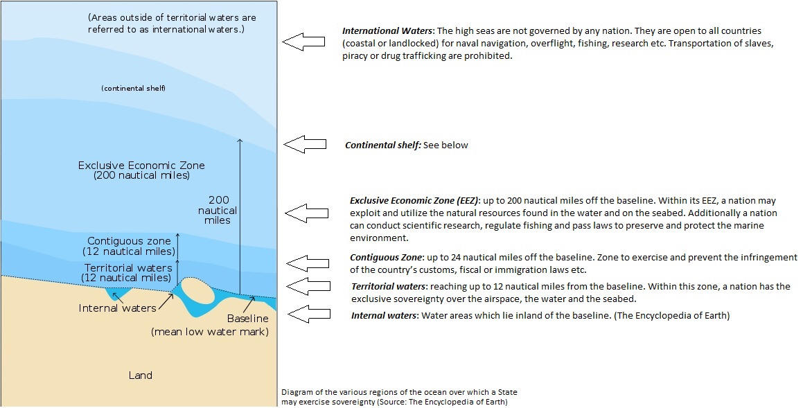
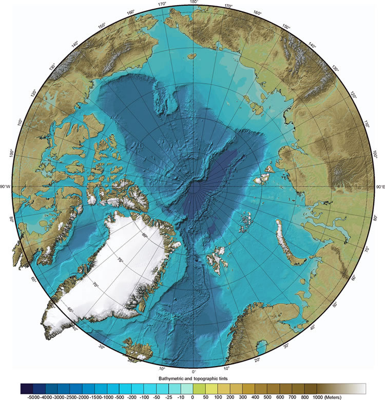 |
Additionally to the maritime border setting, the UNCLOS has established another principle, through which further territorial claims can be made. By looking at the extent of the continental shelf, nations can claim portions of the seabed that might well exceed the 200 nautical mile EEZ (a maximum of 150 additional nautical miles). Unlike the other zone boundaries, the continental shelf is a real and natural geological boundary. The term covers a geological formation which lies between the continental landmass and the deep ocean. The nation to which such a shelf belongs has the right to “explore and exploit the non-living natural resources of the continental shelf as well as the living organisms that live on the seabed itself” (UNCLOS art. 77). The water above the seabed is considered part of the high seas. The map to the left shows
ocean depths in the Arctic. The lighter blue areas are more shallow and
belong to a continental shelf. The darker blue areas are deep ocean
areas. Nations who wish to extend
their sovereignty over an extended portion of their continental shelf
must formally request it “within 10 years of UNCLOS coming into force
for that particular nation” (UNCLOS Annex II, art 4). However, the
extended sovereignty comes with a price. After a five-year development
period, a country has to pay up to seven percent of the produced values
from this area, which will be distributed amongst UNCLOS nations. (The
Encyclopedia of Earth) Norway has already done so and received in 2009 legal support from UNCLOS for a 10 percent extension of its continental shelf - as the first amongst the Arctic states. However, this did not solve the legal question if the other signatories of the Svalbard Treaty have access to the shelf, too. (Norwegian Grand Strategy in the Arctic) Both the Svalbard Treaty and UNCLOS exist separately from each other. As “international legal rules are not hierarchical, in the absence of a treaty abrogating the Spitsbergen Treaty, UNCLOS cannot repeal or add to the Spitsbergen Treaty.” (Scotcher 2011, 24) Each can only bind their own signatory states. (Scotcher 2011, 24) |
Arctic Ocean Bathymetric Map (Source: geology.com) |
Begin year: 1920
End year: ongoing
The dispute of ownerhip of Svalbard can be dated back until before the
Napoleonic Wars. However, the specific conflict over the interpretation
and rights under the Svalbard Treaty (1920) has latently existed for a
couple of decades. The development of UNCLOS in the 1980s put Svalbard
into the focus of more stakeholders. The conflict is not solved yet.
Continent: Europe
Region: Northern Europe
Country: Norway
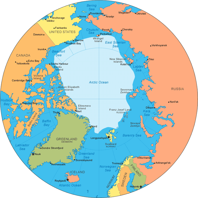 |
| Arctic Ocean Political Map (Source: geology.com) |
The Svalbard islands are located in Northern Europe between the Arctic Ocean, the Barents Sea, the Greenland Sea, and the Norwegian Sea. They belong to the Arctic polar region, which encompasses all areas northward of the Arctic Circle (at 66 33’ N). Svalbard stands for an archipelago consisting of several islands: Spitsbergen, Nordaustlandet, Edge ya, Barents ya, Prince Charles Foreland, Kong Karls Land, and Kvit ya. The total land surface is 62,045 sq km.
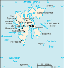
Svalbard (Source: CIA World Fact Book)
Theoretically, all of the signatory states to the Svalbard Treaty could become involved in a conflict over the interpretation of the Svalbard Treaty.
The signatories are: Afghanistan, Albania, Argentina, Australia, Austria, Belgium, Bulgaria, Canada, Chile, China, Czech Republic, Denmark, Dominican Republic, Egypt, Estonia, Finland, France, Germany, Great Britain, Greece, Hungary, Iceland, India, Italy, Japan, Monaco, Netherlands, New Zealand, Norway, Poland, Portugal, Romania, Russia, Saudi Arabia, Spain, Sweden, Switzerland, South Africa, USA, Venezuela (in alphabetical order, as of April 2011) (Norwegian State Department)
So far, the Russia, the United Kingdom, Iceland, Spain, the United States and France have declared disagreement over the interpretation of Treaty provisions and Norwegian unilateral regulations.
Climate Change:
High northern latitudes, including
Svalbard, will experience the largest warming on Earth in the next
century. Climate change in the Arctic has a number of significant
consequences on the environment in Svalbard. The Arctic environment has
seen major changes in the past decades and will continue to change.
Rising surface temperatures are leading to a decrease in perennial sea
ice, a reduction of snow cover and the melting of permafrost. Melting
glaciers around the Arctic are contributing to a rise of worldwide sea
levels. Climatic zones will generally shift northwards (southwards in
the southern hemisphere). Boreal forest will advance into the tundra.
(Turner/Marshall 2011, 12, 13, 341)
Climate predictions about the warming of the Arctic region vary from 2.5 C to 5 C for the next 90 years. The greatest warming is expected to be in the autumn and winter, which is mainly due to the decrease of sea ice both in extent and thickness. The formation of sea ice and the first snow cover will be delayed. Precipitation will increase across the Arctic. As ground temperatures rise, the extent of permafrost soil will also decrease. Thawing soils will release carbon dioxide and methane into the atmosphere, as decomposition reactions speed up. However, the conditions in Europe and the Barents Sea could also change in another direction. The melting of the Greenland Ice Sheet and the flux of cold water into the North Atlantic could weaken the Gulf Stream which brings warm water to northern Europe. A change of ocean circulation could seriously affect the climate in northern Europe. As a result, temperatures in Europe would drop, while the global warming continues. (Turner/Marshall 2011, 13, 345-46, 363-64)
Fishing:
After decades of overfishing in the
Barents Sea, especially by Norway and Russia, a joint Russian-Norwegian
Commission began to set quotas on different fish, such as cod, haddock
and capelin. With regard to cod quotas, Russian Commission members
consistently opposed low quotas. This led to an unsustainable fishing
until, in 2001, the Russian side had to admit the endagerment of the
species and agreed to low quotas. However, Norway has become convicted
that Russian trawlers have been fishing illegally in recent years.
(Sale/Potapov 2010, 131)
Pollutants:
Whereas climate change physically reduces the habitat of many species like polar bears, seals and walrus which are dependent on ice floes, the transfer of pollutants into the Arcitc Ocean harms poses an additional threat to them. Even environmental protection under the Svalbard Treaty cannot protect these species from this influx by ocean and air currents. Pollutants affect the food chain from plankton to fish. The contamination of species at the top of the food chain such as polar bears and seagulls is particularly high and further increasing. High levels of pollutants can negatively affect the development of the populations in Svalbard. (Norwegian Ministry of the Environment)
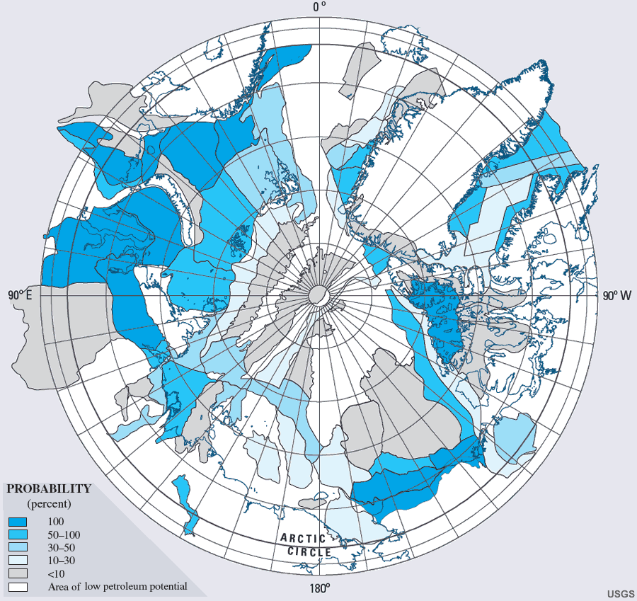 |
Fossil Fuels: A U.S.
Geological Survey report from 2008 shows an extremely high petroleum
potential for many areas north of the Arctic Circle. The research
included quantitative assessments of geologically sound areas
(considered to have at least a 10% chance of significant oil
accumulations) but did not take economic considerations of exploration
and maintenance of resources into account. The results show a 30-50%
probability of at least one oil and/or gas field containing at least 50
million barrels of oil equivalent for the Barents Sea around Svalbard.
(USGS 2008) Arctic Map
7. Type of Habitat: PolarAccording to the Koeppen climate classification, the climate in Svalbard is a polar tundra climate. It is characterised by long periods of perpetual darkness in winter and long periods of continuous sunlight in summer. Due to the long absence of the sun in winter, the temperatures drop very low during that time. In summer, the low elevation of the sun and the reflection of the radiation by snow and ice result in only a moderate rise of temperatures. (Turner/Marshall 2011, 61) 8. Act and Harm SitesMostly off-shore in the EEZ or continental shelf zone. |
| Probability of presence of at least one undiscovered oil and/or gas field with technically recoverable resources greater than 50 million barrels of oil equivalent (MMBOE). (Source: USGS) |
Recent and possible future conflicts
about Svalbard are related to the interpretation of the Svalbard
Treaty, more precisely about the scope of rights of the signatory
states. When the Treaty was signed in 1920, international law had not
yet codified the concept of maritime zones beyond the territorial
waters. When UNCLOS added new maritime zones, such as EEZ and
continental shelf to the jurisdiction of coastal states, it posed two
important questions:
1. Can Norway claim new maritime
areas under the UNCLOS regime that stretch beyond the territorial sea
as recognized in the Svalbard Treaty?
2. Are the rights of equal access for
the contracting parties also applicable in maritime zones beyond the
territorial sea? (Numminen 2011, 10-11)
Until recently, Norway and Russia have
been the only signatories with permanent economic interest and
presence in Svalbard. (Emmerson 2010, 93)
The prospect of large oil and gas findings in the continental shelf of
Svalbard is likely to increase the tensions around the interpretation of
the Treaty. The high number of signatories of the Svalbard Treaty and
the new opportunities which climate change brings in the region make
the emerging dispute over sovereignty and access rights to resources a
global issue. (Numminen 2011, 14) So far, however, the conflict is a
latent one and diplomatic in nature.
Conflict arises when Norway unilaterally imposes economic regulations
in the area. The Norwegian government for Svalbard can exercise its
authority through strong environmental regulations and uses them to
limit other signatories’ economic activities in the area. (Emmerson 2010,
92-93) The most controversial example is the Exclusive Fishery Zone
around the archipelago, which Norway created in 1977. Albeit
non-discriminatory (Norway alloacated quotas to all signatories), this
does restrict economic activities in order to protect resources.
(Scotcher 2011, 22) Additionally, after UNCLOS went into force, Norway
claimed the exclusive access to the EEZ and the continental shelf
around Svalbard (see more below).
Small incidents show tensions especially between Norway and Russia. Until now, they have all been related to fishery rights, rather than exploration of oil or gas fields. In May 2008, the Svalbard governor made a Russian fishery vessel leave a Svalbard port because it lacked “proper documentation” to dock. The Russian protest came promptly, saying the vessel had acted within its Svalbard Treaty rights. (Emmerson 2010, 92-93) In another instance in 2001, a Russian trawler was apprehended for violating Norwegian mesh size regulations in the area. The Russian State Committee for Fisheries threatened to call the Russian Northern Fleet if it was to happen again. This remained a threat and today the relationship between Norway and Russia with regard to the Barents Sea has improved. Last year’s Treaty on Maritime Delimitation and Cooperation in the Barents Sea and The Arctic Ocean solved a decade-long border dispute between the two countries.
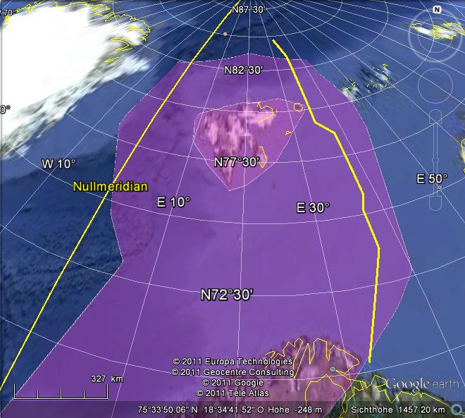 |
The Google map on the left shows the application of the different maritime zones under the UNCLOS regime to Norway's Northern coast. The inner circle around Svalbard indicates the territorial waters and the large pink area represents roughly the size of Norway's EEZ as confirmed by UNCLOS in 2009. The yellow line situated east of Svalbard is the new maritime border between Norway and Russia. The border agreement is the result of a long process of nagotiations which included issues such as fishery rights and oil and gas exploration in the Barents Sea. However, the Russian government was careful to express that the treaty does not solve the question of delimitation and access to Svalbard waters. (Numminen 2011, 13) With regard to the Norwegian claim to the EEZ and the continental shelf around the archipelago, different interpretations of the Treaty exist: Norway’s point of view is quite clear in this matter. It invokes the wording of Article 1 of the Treaty which clearly limits its provisions to the islands themselves and their territorial waters. (See Legal Situation) In the Norwegian interpretation, the special provisions of the Treaty do not extend the above mentioned limits. According to the Norwegian government, it is alone entitled to exercise the right over maritime zones beyond the 12 nautical territorial waters limit. In the past, Canada and Finland have supported this view. But the same argument could be laid against Norway’s sovereignty of these maritime areas. The Svalbard Treaty gave Norway the sovereignty over the specified area and not beyond. If Norway is to extend its jurisdiction to new UNCLOS-covered zones, it must do so under the special conditions of the Treaty. A number of signatory states have expressed their view that Norway is not entitled to exercise sovereignty over the EEZ or a continental shelf. |
In their interpretation of the Svalbard Treaty,
an extension of Norwegian sovereignty over maritime areas must come
with extended economic access, too. They are particularly concerned
with fisheries within the EEZ and oil exploration on the continental
shelf. Amongst those who have openly doubted Norway’s exclusive
entitlement are the United Kingdom, Russia, Iceland and Spain. Other
signatories including the United States, Germany and France, have
publicly reserved “any rights that there may be be under the Treaty.”
(Numminen 2011,11) (Numminen 2011, 10-12)
Low level of conflict. No military incidents. The conflict is mainly visible at the diplomatic inter-state level.
There have not been any documented casualties or deaths until now.
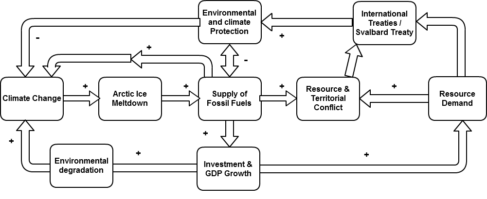 Nowhere
are the effects of climate change more visible than in the Arctic
region. The diagram shows the dynamics between climate change and
conflict potential in the Svalbard area. The thawing of the thick ice
sheets that cover huge parts of the Arctic ocean open up to
increasing areas of icean surface in the summer. As a consequence, the
seabed and what is expected inside become more easily accesible. As the
USGS Survey report shows, this is likely to lead to an increased supply of fossil fuels.
Nowhere
are the effects of climate change more visible than in the Arctic
region. The diagram shows the dynamics between climate change and
conflict potential in the Svalbard area. The thawing of the thick ice
sheets that cover huge parts of the Arctic ocean open up to
increasing areas of icean surface in the summer. As a consequence, the
seabed and what is expected inside become more easily accesible. As the
USGS Survey report shows, this is likely to lead to an increased supply of fossil fuels.
However, the question is who owns the resources. The highest probability for oil and gas sources are located around the coasts and would have to be dealt with through UNCLOS. However, in cases like Svalbard the sovereignty and ownership is not clear. Growing global resource demand is therefore the second major driver for developments in the Arctic.
The exploration of new energy sources in the Arctic would bring investment in the region and economic growth to buyers and sellers of the fuels. Growing economies generate a higher resource demand and further environmental degradation and greenhouse gas emissions. The feedback loop to climate change will become even bigger. On the other hand, measures taken to protect the climate and environment in general require regulation and consent through international treaties. The Svalbard Treaty includes a commitment to "ensure the preservation and, if necessary, the re-constitution of the fauna and flora of the said regions" (Article 2 of the Svalbard Treaty). Depending on the priority the environmental conservation receives in the application of the Treaty, it could complicate or hinder the oil and gas production and help mitigate further climate change. However, the feedback loop from protection measures today to actual impact on the climate can take decades or even centuries. (Ruddiman 2005, 152)
Deposits of oil and gas will increase the level of strategic importance of Svalbard. In light of retreating ice sheets and the depletion of current fossil sources, Svalbard could become a priority on the economic and energy agenda of many stakeholders.
Another issue which will gain strategic importance over the next years is the opening up of the Northern Sea Route (also called North East Passage) along the Northern Russian coast. Today, large parts of the Northern Sea Route are still covered with ice year round. The transit season along the Russian coast is a mere four months per year. However, the use of the Northern Sea Route could significantly shorten many sea routes. For example, the distance from any Asian port north off Hong Kong to London is shorter via the Northern sea Route compared to the Suez Canal route. The distance from Troms in Northern Norway to Vancouver is 3,350 nautical miles shorter than the conventional route via Panama. The sea between the Northern coast of Norway and Svalbard is a part of the Northern Sea Route and could thus gain additional strategic significance in the future. ( streng 1994, 159-163)
“The conflict over the application of
the Spitsbergen Treaty is symbolic of a wider shift in the contentious
areas of international law. Most potential areas of dispute over
sovereignty in the Arctic today are related to the sea and the seabed,
rather than the land.” (Emmerson 2010, 94) The process towards any
large-scale exploitation of fossil fuels in the Svalbard area and in the
Arctic in general could take a long time and be technologically
complicated. The fact that tension about these resources is already
clearly visible today could improve the likelihood of finding
strategies to diffuse it. However, the strategic profile of the Arctic
will rise, indicated by a subjective change of attitudes already.
(Bailes 2011, 35). The resolution of the dispute about the scope and
application of the Svalbard Treaty cannot not lie in the UNCLOS regime,
which is too wide. Instead, the Treaty itself needs to be amended in
light of the new UNCLOS concepts. A peacefully negotiated amendment of
the Treaty can help preserve the object of the Svalbard Treaty:
equitable and peaceful cooperation in the archipelago. An amended
Svalbard Treaty could also serve as a “framework for resolving tensions
in the area.” (Scotcher 2011, 30) (Scotcher 2011, 35-37)
To conclude, it is important to note that according to the Svalbard Treaty, the archipelago is a de-miliarised zone. Any attempt by a signatory state to use military in order to enforce their economic rights would breach the Treaty itself. If the signatories want to keep up the Svalbard regime, they must solve the conflict with non-military means. However, if the signatories do not find a way to agree on a common understanding of the Treaty, there is no guarantee that it will survive another 90 years. In the light of increasing fuel demand and decreasing supply, the conflict for Arctic resources, including those in the Svalbard area, will intensify and might even lead to an armed conflict. One way to avert this scenario would be a clear definition of sovereignty and ownership rules in the entire Arctic. Complementary to this, an accelerated transition to a low-carbon economic system could prevent both the complete melt down of the Arctic and armed conflict for resources.
Related ICE cases:
Search criteria: Polar regions (5), Northern Europe (2), Cool Habitat (4), Multilateral conflict, Resources as trigger (4)
| 57% = 13 (score)/ 23 (total poss) | No.50 - Novalya |
| 52% = 12 (score)/ 23 (total poss) | No.94 - Vineland |
| 52% = 12 (score)/ 23 (total poss) | No.104 - Russnuke |
| 52% = 12 (score)/ 23 (total poss) | No.112 - Neanderthal |
| 52% = 12 (score)/ 23 (total poss) | No.67 - Cancod |
| 48% = 11 (score)/ 23 (total poss) | No.89 - Iceman |
| 48% = 11 (score)/ 23 (total poss) | No.96 - Teak |
| 48% = 11 (score)/ 23 (total poss) | No.63 - Khmer |
| 48% = 11 (score)/ 23 (total poss) | No.36 - Alaska |
| 48% = 11 (score)/ 23 (total poss) | No.79 - Diamond-SL |
Literature:
Bailes, A. (2011). Spitsbergen Treaty in a Sea of Change. The Spitsbergen Treaty - Multilateral Governance in the Arctic. Arctic Papers, Volume 1, 34-37.
Emmerson, C. (2010). The Future History of the Arctic. New York, NY: Public Affairs.
Numminen, L. (2011). A History of the Functioning of the Spitsbergen Treaty. The Spitsbergen Treaty - Multilateral Governance in the Arctic. Arctic Papers, Volume 1, 7-20.
Ostreng, W. (1978). Politics in High Latitudes: The Svalbard Archipelago. (Christophersen, R.I., Trans.) London: C. Hurst & Co. (Publishers).
Ostreng, W. (1994). The Northern SEa Route and the Barents Region. In Schram Stokke, O. & Tunander, O. (Eds.), The Barents Region. Cooperation in Arctic Europe (159-172). London: SAGE Publications Ltd.
Ruddiman, W.F. (2005). Plows, Plagues and Petroleum. How Humans Took Control of the Climate. London: Princeton University Press.
Sale, R. & Potapov, E. (2010). The Scramble for the Arctic. Ownership, Exploitation and Conflict in the Far North. London: Frances Lincoln Ltd.
Scotcher, N. (2011). The Sovereignty Dilemma. The Spitsbergen Treaty - Multilateral Governance in the Arctic. Arctic Papers, Volume 1, 21-33.
Stauffer, P.H. (ed.): Circum-Arctic Resource Appraisal: Estimates of Undiscovered Oil and Gas North of the Arcitc Circle, U.S. Geological Survey (2008) Available as PDF at: http://pubs.usgs.gov/fs/2008/3049/
Turner, J. & Marshall, G.J. (2011). Climate Change in the Polar Regions. New York, NY: Cambridge University Press.
Wallis, D. (2011). Introduction. The Spitsbergen Treaty - Multilateral Governance in the Arctic. Arctic Papers, Volume 1, 5-6.
Websites:
Central Intelligence Agency, World Fact Book: Svalbard https://www.cia.gov/library/publications/the-world-factbook/geos/sv.html
Geology.com, Who owns the Arctic? http://geology.com/articles/who-owns-the-arctic.shtml
World Maps of Köppen-Geiger climate classification: http://koeppen-geiger.vu-wien.ac.at/present.htm
Global Brief, Norwegian Grand Strategy in the Arctic http://globalbrief.ca/blog/in-situ/norwegian-grand-strategy-and-the-arctic/3803
Norwegian Ministry of the Environment, Environmental Protection in Svalbard: http://www.regjeringen.no/en/dep/md/selected-topics/svalbard_og_polaromradene/environmental-protection-in-svalbard.html?id=279713
Norwegian State Department Treaty Register, Svalbardtraktaten: http://www.lovdata.no/traktater/index.html
Norwegian Government website, Treaty between the Kingdom of Norway and the Russian Federation concerning Maritime Delimitation and Cooperation in the Barents Sea and the Arctic Ocean: http://www.regjeringen.no/upload/smk/vedlegg/2010/avtale_engelsk.pdf
University of Oslo, Faculty of Law, The Svalbard Treaty: http://www.jus.uio.no/english/services/library/treaties/01/1-11/svalbard-treaty.xml
United Nations Convention on the Law of the Seas (UNCLOS) http://www.un.org/depts/los/convention_agreements/texts/unclos/closindx.htm
The Encyclopedia of Earth: United Nations Convention on the Law of the Sea (UNCLOS): http://www.eoearth.org/article/United_Nations_Convention_on_Law_of_the_Sea_%28UNCLOS%29,_1982
World Maps of Koeppen-Geiger Climate Classification http://koeppen-geiger.vu-wien.ac.at/present.htm
Images:
Geology.com, Arctic Ocean Bathymetric Map http://geology.com/world/arctic-ocean-map.shtml
Geology.com, Arctiv Ocean Political Map http://geology.com/world/arctic-ocean-map.shtml
CIA World Fact Book, Svalbard https://www.cia.gov/library/publications/the-world-factbook/geos/sv.html
The Encyclopedia of Earth, Diagram of the various regions of the ocean over which a State may exercise sovereignty http://www.eoearth.org/article/United_Nations_Convention_on_Law_of_the_Sea_%28UNCLOS%29,_1982
United States Geological Survey (USGS), Petroleum Potential of Assessment Units and Provinces in the Circum-Arctic - Probability (Percent) http://pubs.usgs.gov/fs/2008/3049/
Travelblog.com Svalbard - the black mountains of the north http://www.travelblog.org/Photos/panorama-6358.html