1.1 Abstract
This case study is set to analyze the brewing crisis in the Ferghana Valley in Central Asia. The focus will be on the growing water use conflicts arising in the valley and the effects on the mix of ethnic communities scattered throughout the valley, split strategically between countries borders created by Stalin.
1.2 Description
Ferghana Valley Soviet History
Ferghana Valley - 1918-1924
Turkestan Autonomous Soviet Socialist Republic was created from the Turkestan Krai of Imperial Russia. Its capital was Tashkent, population about 5,000,000.
Image Source: Wikipedia
Ferghana Valley - 1925-1989
In 1924, Turkestan ASSR was partitioned into two Soviet Socialist Republics (SSR), Turkmen SSR and Uzbek SSR. Turkmen SSR matched the borders of today's Turkmenistan. The Bukhara and Khorezm People's Soviet Republics were absorbed into Uzbek SSR, which also included other territories inhabited by Uzbeks as well as those inhabited by ethnic Tajiks.
In 1929 the Tajik Soviet Socialist Republic (Tajik SSR) was created from the Uzbek SSR for the Tajik ethnic population.
Kirghiz SSR (today's Kyrgyzstan) was created in 1936; upgraded to a Republic from the Kara-Kirghiz Autonomous Oblast. Kazakh SSR was also created at that time, December 1936.
Image Source: Wikipedia
Ferghana Valley - 1991-Present
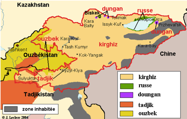
The valley straddles Uzbekistan, Kyrgyzstan and Tajikistan.
The area remains Muslim, populated by ethnically Uzbek, Tajiks, and Kyrgyz, often intermixed and not matching modern borders. As well there are substantial populations of Russian, Kashgarians, Kipchaks, Bukharan Jews and Romani minorities.
Image Source: GoogleEarth 2011
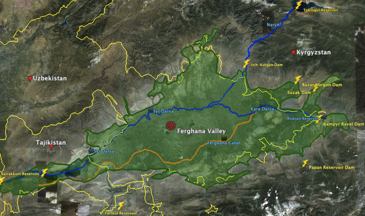
Ferghana Valley - Current Issues
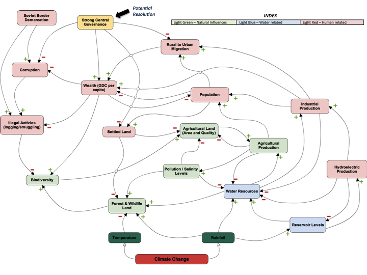
Nowhere else on earth are three countries so highly interdependent in terms of water and energy. Tajikistan, Kyrgyzstan and Uzbekistan share borders that have been rather artificially created during the Soviet Union era. These borders did not matter very much during Soviet times, but became actual international boarders with meaning after independence, giving rise to numerous cross-border conflict situations, especially around access and management of land and natural resources (in particular water). Infrastructure (such as roads, railways, irrigation systems, canals, water pipes, etc.) was often established without consideration for the borders, making their management extremely complex after independence. In some parts, the border cuts through villages and even backyards of houses. Roads meander repeatedly across borders. Water pump stations may be located on one side of the border to provide irrigation water to the other side.
The collapse of the Soviet Union lead to a comprehensive change in the economic structure of the region. During Soviet times the major of the population in the Fergana valley worked on collective farms, which guaranteed a low but stable standard of living. However after the breakup and the rise of the independent countries the local populace has experienced an end to their relatively carefree life. In addition, the few industrial enterprises in the region have either closed down or are working at a substantially lower level.
As the newly formed republics began to privatize state farms and carried out this program throughout the region, these private farms are now of utmost importance as they are now the only reliable sources of family income or at least subsistence farming. The agricultural activities in the valley, such as those that previously concentrating on cattle breeding, soon shifted to subsistence farming. The individual demand for irrigation water on small fields rose sharply. However, since hardly anybody paid for the provided resource the existing distribution systems, mainly consisting of open concrete canals, have fallen in disrepair or having even been taken apart and sold as scrap.
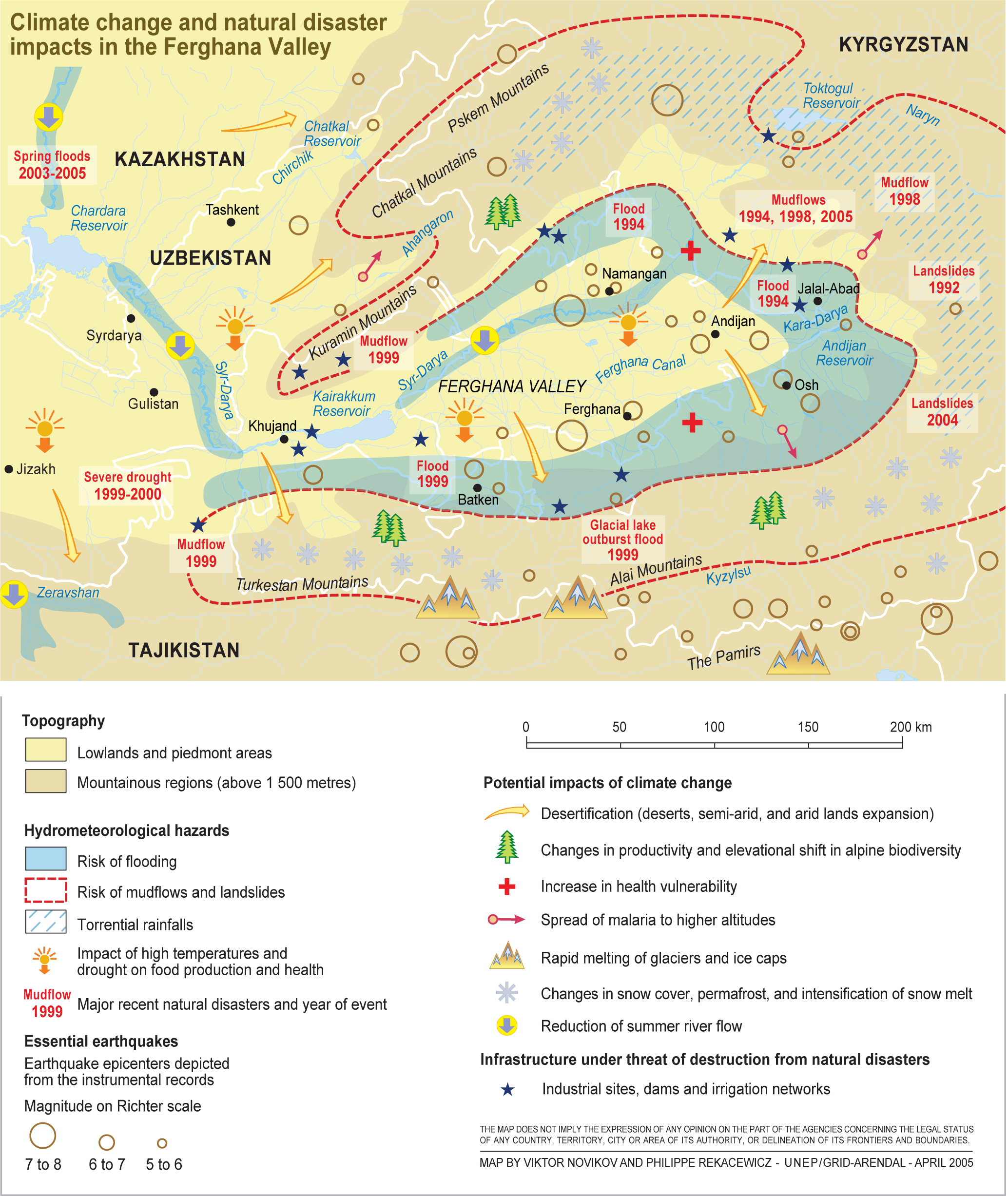
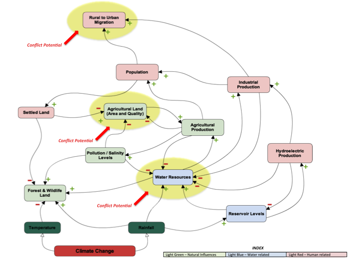
Strain on Natural Resources
Threats to fresh water resources in Ferghana Valley
The increased demand for water and energy resources have come to head with the fact that rainfall has been decreasing and temperatures have been increasing.
The increasing need for irrigation water is conflicting with the increase demand for electrical production via dams as access to other fuel sources have demised with the collapse of the Soviet systems.


1.3 Duration
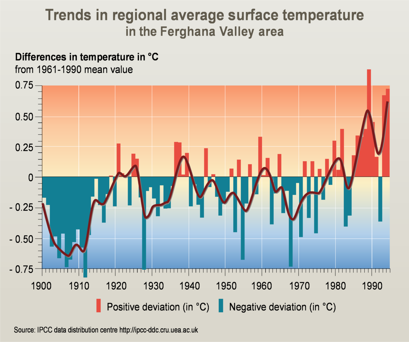 |
Trends in regional average surface temperature in the Ferghana Valley area. |
| Source: Viktor Novikov, UNEP/GRID-Arendal. Trends in regional average surface temperature in the Ferghana Valley area. UNEP/GRID-Arendal Maps and Graphics Library. 2005. |
Over the past 30 years the average regional surface temparature in the Ferghana Valley region has increase significantly, on average about .5 degrees C.
This is an important factor when looking at the region in terms of environment and security is the impact of climate change in Central Asia in general, and Ferghana Valley in particular.
In the Ferghana valley it is likely that climate change will primarily affect sector related to water and agriculture. Central Asia is likely to have a shortage of water associated with a significant increase in air surface temperatures.
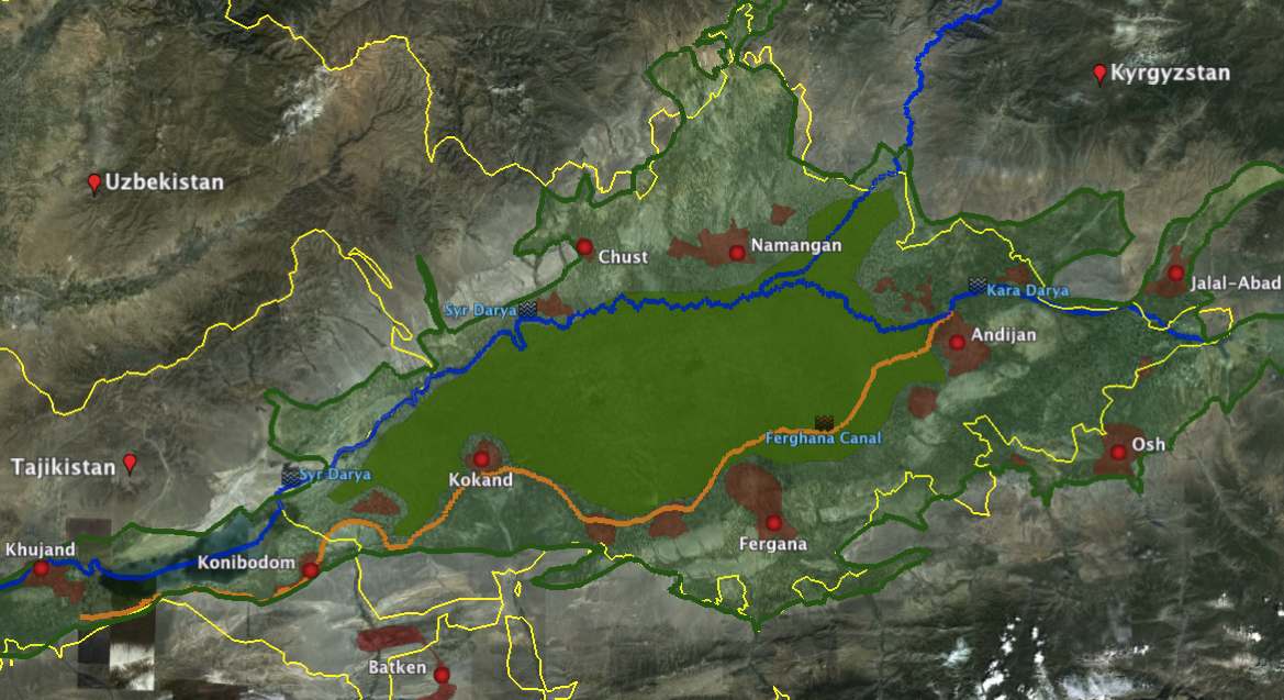
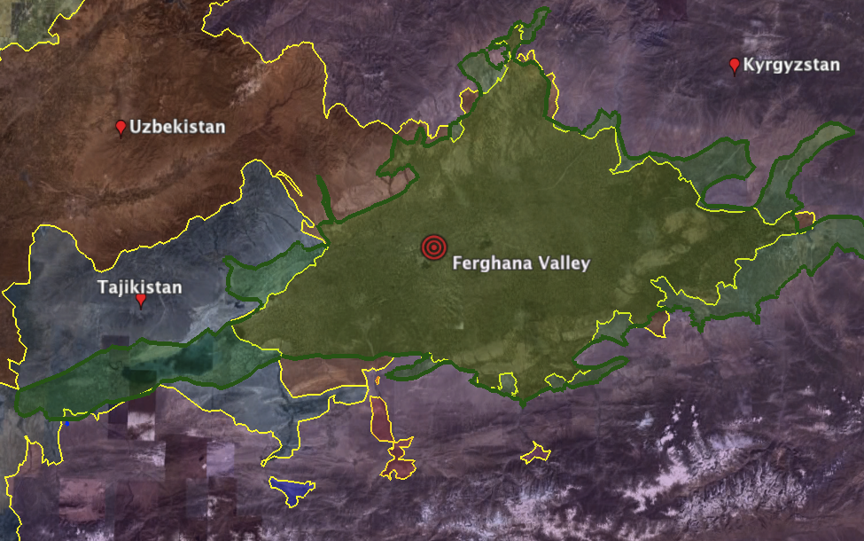
1.4 Location
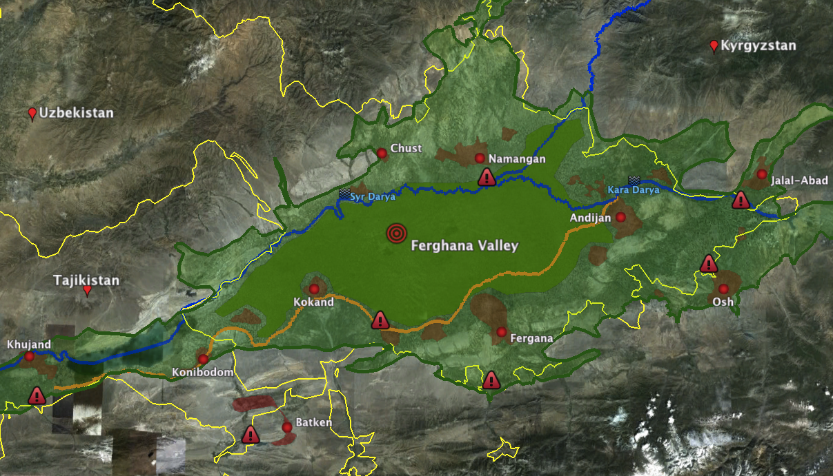
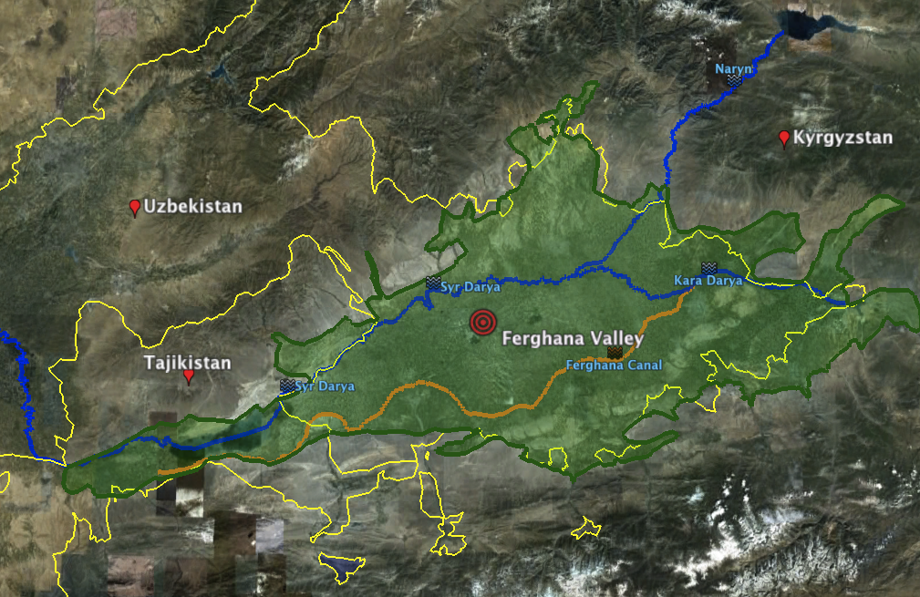
The Ferghana Valley is a region in Central Asia spreading across eastern Uzbekistan, Kyrgyzstan and Tajikistan. A large triangular valley in what is an often dry part of Central Asia, the Ferghana Valley is at the intersection of two rivers, the Naryn and the Kara Darya, which run from the east, joining near Namangan, forming the Syr Darya river.
Ferghana Valley - Valley Delineation
Source: GoogleEarth 2011
The borders, clearly visible in this map, of the three countries were artificially created during the Soviet Union era, stemming from Stalins objective of "divide and rule", which denied any one country from controlling all the resources in the valley. As a result, Tajikistan has a large Uzbek and a smaller Kyrgyz minority, Kyrgyzstan has Uzbek and Tajik minorities and Uzbekistan has a large Tajik and smaller Kyrgyz minority.
In addition, between the three countries in the valley, there exists approximately 7 enclaves in the valley, in addition to causing confusion and ethnic tensions, these enclaves have been promoted by the respective governments as providing ideal safe havens for armed terrorist groups such as the Islamic Movement of Uzbekistan (IMU), who have launched a number of raids in the past, weaving in and out of Kyrgyz and Uzbek territory to evade capture.
Ferghana Valley - Enclave Locations
Source: UNEP/GRID-Arendal. Oblasts in the Ferghana Valley area. UNEP/GRID-Arendal Maps and Graphics Library. 2005. LINK
Kyrgyzstan Enclaves
There is one exclave, the tiny village of Barak (population 627), in the Fergana Valley. The village is surrounded by Uzbek territory. It is located on the road from Osh (Kyrgyzstan) to Khodjaabad (Uzbekistan) about 2miles north-west from the Kyrgyz-Uzbek border in the direction of Andijan.
Uzbekistan Enclaves
There are four Uzbek enclaves within Kyrgyzstan. Two of them are the towns of Sokh (125 sq. miles with a population of 40k-70k; with 99% are Tajiks, the remainder Uzbeks) and Shakhimardan (35 sq. miles, population of 5,100; 91% are Uzbeks, the remainder Kyrgyz). The other two are the tiny territories of Chong-Kara (roughly 2 mi by 0.6 mi) and Jangy- ayyl. Chong-Kara is on the Sokh river, between the Uzbek border and the Sokh enclave. Jangy- ayyl is about 60 kilometres (37 mi) east of Batken, in a northward projection of the Kyrgyz-Uzbek border near Khalmion.
Tajikistan Enclaves
There also are two enclaves belonging to Tajikistan within Kyrgyzstan: Vorukh (37-50 sq mi, pop. between 23,000 and 29,000, 95% Tajiks and 5% Kyrgyz, distributed among 17 villages), located 28 mile south of Isfara on the right bank of the Karafshin river, and a small settlement near the Kyrgyz railway station of Kairagach.
1.5 Actors
- Fergana Valley
- Kyrgyzstan
- Tajikistan
- Uzbekistan
The Fergana Valley
Countries
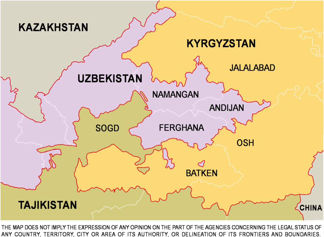
The Valley is now divided between Uzbekistan, Kyrgyzstan and Tajikistan. In Tajikistan it is part of Soghd Province or vilayat, with the capital at Khujand. In Uzbekistan it is divided between the Namangan, Andijan and Fergana viloyati, while in Kyrgyzstan it contains parts of Batken, Jalal-abad and Osh oblasts, with Osh being the main town for the southern part of the country.
Population Demography
Currently characterized by a high density population, the Ferghana Valley holds a very significant portion of three countries' overall population 27% of Uzbekistan, 31% of Tajikistan and 51% of the Kyrgyz Republic, with an overall population of 10 millions people (up to 250hab/km2 to be compared with the average of 14 hab/km2 in Central Asia).
Country
Major Cities
Area (km²)
Population
Uzbekistan
Andijan
4,200
1,900,000
Fergana
6,800
2,600,000
Namangan
7,900
1,860,000
Kyrgyzstan
Batken
17,000
400,000
Osh
29,200
1,300,000
Jalal-Abad
33,700
962,000
Tajikistan
Khujand
25,400
2,100,000
TOTAL
124,200
11,342,000
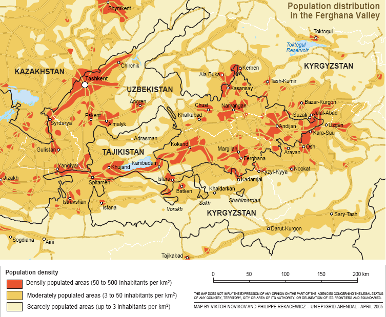
Population Density Across Fergana Valley
The Fergana valley is the most populous area in Central Asia. With these high population densities of mixed ethic groups located throughout this confined region, the result is a significant increase in competition for the dwindling natural resources left, which can lead to confrontations and even armed conflict for their control.
Source: UNEP/GRID-Arendal. Population distribution in the Ferghana valley . UNEP/GRID-Arendal Maps and Graphics Library. 2005. LINK
Area: 198,500 sq km
Population: 5.5 million
Capital City: Bishkek
People: 67% Kyrgyz, 14% Uzbek, 11% Russian,1% Ukrainian, Dungan, Uighur
Languages: Kyrgyz and Russian
Religion(s): Muslim/ Russian Orthodox and other Christian minorities
GDP: US$4.681 billion
Major Industries: Mining, hydropower, agriculture
Major trading partners: Russia, China, Kazakhstan, Switzerland, UzbekistanKey Facts:
Kyrgyzstan remains one of the poorest countries of the Former Soviet Union, and the world.
The Kyrgyz economy was severely affected by the collapse of the Soviet Union and the resulting loss of its vast market.
Agriculture is the largest sector of the economy accounting for 32% of GDP and more than half of all employment. Among Kyrgyzstan's mineral reserves are substantial deposits of deep-seam coal, gold, tin, uranium and other rare-earth metals.
Kyrgyzstan has negligible petroleum and natural gas reserves. The economy is heavily dependent on gold exports, and changes in production levels impact dramatically upon GDP.
Area: 143,100 sq km
Population: 7.37million (Economist Intelligence Unit, 2010)
Capital City: Dushanbe (population: 0.7 million)
People: Tajiks 80%, Uzbeks 15%, Russians 1% and Others 4%
Religion(s): Sunni Muslim 85%, Ismaili Shiites 5%, some Russian Orthodox Christians and Jews.
Languages: Tajik and Russian
GDP: US$3.7bn
Major Industries: Nonferrous metallurgy, mining, hydro-power, textiles, cotton, fruit.
Major trading partners: Russia, China, Turkey, EU, IranKey Facts:
Tajikistan has a Gross National Income (per capita) of 700 US Dollars (World Bank 2009), making it the poorest of the former Soviet states.
The poor state of the roads, limited external transportation links and other infrastructure weaknesses hinder development.
The rationing of electricity in winter - when most of the country outside the capital receives no more than four hours (or less) of electricity a day - has serious implications for the ability of industry or IT to operate.
Most of the manufacturing plants from Soviet times have been abandoned, but have not been replaced by new production.
Around 75% of exports derive from a single large aluminium plant.
Cotton is the most important crop, accounting for about 9% of exports.
47.2% of the population is estimated to live below the official poverty line (World Bank, 2009). The level of extreme poverty is 17.5%.
The lack of job opportunities drives over a million Tajiks to seek work abroad as migrant labourers (mainly to Russia and Kazakhstan) and their remittances form a major part of the Tajik economy.
Area: 448,971 sq km
Population: 27.5m
Capital City: Tashkent
People: 80% Uzbek, 5.5% Russian, 5% Tajik, 3% Kazakh, 2.5 Karakalpak, 1,5% Tatars, 2.5 other
Languages: Uzbek/Russian/Tajik
Religion(s): Sunni Muslim (88%), Eastern Orthodox (9%), other (3%)GDP: US$ 30.68bn
Major Industries: Mining, coal and oil production, hydroelectric power.
Major trading partners: Russia, China, Kazakhstan, South Korea, Turkey, Bangladesh, UkraineKey Facts:
Uzbekistan has substantial natural resources, including gas, oil, gold and silver.
Uzbekistan is the world's 3rd largest exporter of cotton.
In the absence of substantive economic reform, the strength of the Uzbek economy is largely dependent on gold and cotton prices.
Uzbekistan’s Muslim population has a secular and moderate tradition - but there is a danger that growing poverty, unemployment, combined with restrictions on political and religious freedom, could drive elements of the population towards extremism and terrorism.