CASE BACKGROUND
ENVIRONMENT ASPECT
CONFLICT ASPECT
ENVIRONMENT OVERLAP CONFLICT ASPECT
RELATED INFORMATION
The Nile is formed by three tributaries, the Blue Nile, the White Nile, and the Atbara. The White Nile rises from its source in Burundi, passes through Lake Victoria, and flows into southern Sudan. There, near the capital city of Khartoum, the White Nile meets up with the Blue Nile which has its source in the Ethiopian highlands, near Lake Tana. Over 53% of the Nile's waters come from the Blue Nile. The two flow together to just north of Khartoum, where they are joined by the waters of the Atbara, whose source is also located in the Ethiopian highlands (Ody, 1).
The river then flows north through Lake Nasser, the second largest man-made lake in the world, and the Aswan Dam before splitting into two major distributaries just north of Cairo. The two distributaries are the Rosetta branch to the west and the Darneita to the east. In ancient times, the number of distributaries was much greater, but slow water flow, human interference, and the accumulation of silt had led to the disappearance of all the other major distributaries. This has effectively led to the desertification of large stretches of Egyptian land.(Ody, 1)
The Conflict
In ancient Egypt, the Nile, and its delta, were worshiped as a god. The god Hapi, who came in the shape of a frog, represented the Nile delta. Several times throughout history, Egyptians have tried to unify the Nile valley under their rule by conquering the Sudan. The lands to the south of them that bordered the river were in constant danger. The Sudan was invaded during the reign of Queen Sheba, during the Roman rule of Nero, and countless other times. This is because the Egyptians have always feared that one day the Nile's waters would no longer reach their country. People believed, that since the flow of the Nile was so unpredictable, something had to have been affecting it. A legend says that during one particularly bad famine in Egypt, the Egyptian Sultan sent his ambassadors to the king of Ethiopia in order to plead with him not the obstruct the waters. A Scottish traveler in the 18th century recounted a story that the King of Ethiopia had sent a letter to the pasha in 1704 threatening to cut off the water. Given this fear it is quite natural that the Nile countries desire to secure their water supplies.(Collins, 3-4)
The modern history of the Nile conflict began with the 20th century. The English were quick to realize the importance the river would have for their colonies. Over the centuries, in the swamps of the Sudd, strong winds and the force of the river had created natural dams made up of plants and soil, similar to those made by beavers. These dams had made all navigation up the Nile past a certain point completely impossible. Soon after Sudan was reconquered in 1898, the English began to free the Nile of the vegetation which was obstructing the passage of ships. By the time enough blockages had been removed to clear a path through the Sudd in 1904, the English had already begun drawing up massive alternative drainage plans in order to ameliorate the flow of the Nile. However, the British did not control the Ethiopian portions of the Nile, from which over 80% of the Nile's waters come. Therefore, they had to sign an agreement with the Ethiopians in 1902 in order to assure themselves that the Nile would not be interfered with. They also had to assert a significant amount of pressure on the Italians and the French so that they would not interfere with the french dominance of the Nile basin (Collins, 67-100). This approach worked well with the Italians, but a little less well with the French. The Egyptians caused the most problems for the English as planned developments on the Nile became a disputed matter between the two governments. In 1929, Great Britain sponsored the Nile Water Agreement, which regulated the flow of the Nile and apportioned it use (Glassman, 150).
After World War II, the British government commissioned a complete hydrological study to be made of the Nile Basin as a whole. Unfortunately, the study was not able to include the Ethiopian portions of the Nile due to political problems. The rest of the Nile valley was included. The study was finally released in 1958 as the Report on the Nile Valley Plan. It was the culmination of 50 years of study. The report suggested various ways to increase the amount of water which reached Egypt. The most important of these suggestions was the construction of the Jonglei canal, which would divert the flow of the Nile in southern Sudan (in the Sudd) to avoid the enormous evaporation losses which occur there. The report, however, treated the entire Nile Basin as a single unity, which was unacceptable to the newly independent African states, especially since it was published just two years after the Suez Canal incident (Ohlsson, 31-34)
Furthermore, the Egyptians had already planned a major construction which would significantly improve the flow of the Nile in their territories. They had decided to build the High Aswan Dam in order to control the yearly floods of the Nile and in order to harvest the hydroelectric power of the river. However, this project was to have major repercussions on the lands of northern Sudan. Building this dam would mean that whole sections of northern Sudan would be inundated by what was to be Lake Nasser. There were also severe environmental concerns as to how the dam would change life on the banks of the Nile. To deal with this problem, the two nation signed an agreement on the "full utilization of the Nile waters" in 1959. This agreement stipulated that Sudan's yearly water allotment would rise from the 4 billion cubic meters stipulated in the 1929 agreement to 18.5 billion cubic meters. The Sudan would also be allowed to undertake a series of Nile development projects, such as the Rosieres Dam and the Jonglei Canal. In exchange, Egypt would be allowed to build a huge dam near the Sudanese border which would regulate the flow of the river into Egypt and provide water during droughts. The result of this dam, however, would be the inundation of over 6,500 square kilometers of land. The treaty also formed a joint committee which would be in charge of supervising and directing all development projects which affected the flow of the river (Ohlosson, 35-40).
This agreement was only bilateral and did no include any of the other riparian countries of the Nile despite the fact that it portioned out all of the Nile's water. Ethiopia, from which 80% of the water comes from was not even consulted and no water was even allotted for future usage by any upstream country except Sudan. All of the Nile's average water flow is divided between the two most downstream countries. Nevertheless, this 1959 agreement is still the most comprehensive agreement ever signed on the use of the Nile's waters.
Apparently, the residents of northern Sudan and southern Egypt were
not consulted on the treaty either. In the 1960's, over 100,000 Nubians
lost their homes due to development projects stemming from that treaty.(Pearce,
29) Some of these same people had to be moved again in the 1990's in order
to build another dam, this time near the border with Ethiopia. The government
of Sudan says that these people will be compensated, but the overwhelming
feeling amongst the villagers is that they will not be. One villager claimed
"We were not informed when the government decided... to build a dam in
our area. They just sent tractors with a large number of strangers. These
strangers were surveyors." (Nhail, 1-3).
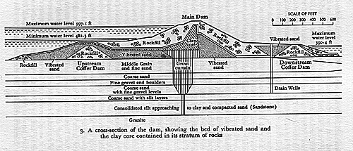
Construction of the High Dam at Aswan began in 1959 -- as soon the agreement with Sudan was signed. When it was finally finished in 1970, the dam was more than 17 times the volume of the Great Pyramid at El Giza. It now stretches 4 kilometres across the river's path, rises over 100 meters for its base, and is almost a kilometer thick. Behind it, the waters have formed Lake Nasser, which is 600 kilometers long and 50 kilometers wide in some places. This reservoir is the second largest man-made lake in the world. The Aswan Dam is arguably one of the great architectural accomplishments of the 20th century. To build it, Egypt had to obtain outside funding, because it was to cost over one billion dollars to build. Rebuffed by the United States and the World Bank, Nasser had to turn to the Soviet Union, which was only too glad to help (Pearce, 28-29)
In the 1970's Sudan and Egypt began the joint construction of the Jonglei Canal, which would have increased the flow of the Nile waters by diverting the Nile away from an area where a great deal of water is lost to evaporation. Unfortunately, construction was stopped in 1983 one hundred kilometers short of completion due to "rebel action". The civil war in the Sudan has taken its toll on the development project, which was funded in large part by the World Bank. The failure of this project was a great failure for both the Sudanese government and the World Bank. Over 100 million dollars were spent on the Jonglei Canal project (Pearce, 31).
The most complete agreement on the use of the Nile waters remains the 1959 agreement between Sudan and Egypt. This agreement, however, did not put an end to the conflict over the rights to the Nile waters. A strong tension still exists between the Nile basin countries whenever a new Nile development project is proposed. The water needs of all of these countries are barely being met now and will probably not be met in the future, especially in view of the development plans in Ethiopia and Sudan. In addition, Egypt, as the country most in danger of losing access to the Nile waters by development projects in other countries, remains willing and able to intervene militarily in order to keep the status quo.
In August 1994, it was reported that Egypt had planned and subsequently canceled an air raid on Khartoum, in Sudan, where a dam is being built. This is in addition to the tensions between Sudan and Egypt over the attempted assassination of President Muhbarach in the summer of 1995. Border clashes became common between the two neighbors and conflict seemed probable. The tensions have now seemed to subside, but there is no telling when and if they will resume.(El-Kohdary, 1-3)
Egypt has also acted against Ethiopian development on the Nile in the past. In the early 1990's, it is believed that Egypt blocked an African Development Bank loan to Ethiopia for a project which might have reduced the flow of the Nile's water into Egypt. This behavior is not unwarranted given predictions by USAID that Egypt will experience a 16 to 30 percent water deficit by the end of the century. This will probably be further increase by further Egyptian development projects planned for the Nile. (El-Kohdary, 1-3)
In 1997, Egypt is to begin the construction of a new valley of the Nile, but creating a new, self-sustaining, river which would flow through the Western Desert. To do this they would cut a canal, called the New Valley Canal, which would connect a series of oases to one another. This would allow Egypt to settle a large number of people far from the Nile; something which has proven impossible up until now. Over 62 million people live on just 4% Egypt's land. This project would allow Egyptians to take advantage of the good soil quality which is prevalent throughout the country. However, the estimated cost of the project is 2 billion dollars, which Egypt does not have. However, the real problem remains that of where Egypt will find the water to fill the canal and to keep it flowing as it already its full allotment of the Nile's water (Daniszewski, A1, A16)
Region: Mideast Africa
Country: Egypt

The waters, however, do not flow in sufficient quantities to satisfy the future water requirements of all these nations. The nations are barely satisfied by what they now receive and it is foreseen that their needs will increase as populations rise, industrial growth takes place, and more land is irrigated with Nile water for agricultural use in nations besides Egypt. Egypt's cropland is already 100% irrigated, fostering an amazing reliance on the flow of the Nile. It is estimated that Ethiopia and Sudan could achieve high levels of food production if they chose to irrigate as much land as possible.
Water stress is present when nations find themselves with less than 2000 cubic meters per person of renewable water supplies. By the end of the century at least five nations in the Nile basin expect themselves to be suffering from water stress. This figure does not include the water that would be needed to feed the citizens of the Nile countries. It is unlikely that the flow of water in the Nile could be increased without the completion of the Jonglei Canal, which, given Sudan's internal problems, seems highly unlikely in the near future. (Ohlosson, 178-194)
In addition, the environmental situation is further complicated by the problems surrounding the Aswan Dam. Even though the environmental damage to Egypt's environment caused by the Dam has been much less than originally predicted, it is still quite significant. One major problem is that the silt from the river which for millennia fertilized Egypt's cropland is no longer being allowed to flow down the river. This means that more chemical fertilizers are being used. It is also causing erosion along the banks of the Nile, which were previously replenished by the silt carried down the river. Much of the Nile delta is now being swept into the Mediterranean. In fact, if barriers near the Nile's outlet continue to erode, much of low lying Egypt could find itself in the sea, as the sea slowly advances. The Nile is also bringing more salt to the fields of Egypt because of the increased evaporation which takes place in Lake Nasser. (Pearce, 32)
This evaporation also presents a severe problem. Over 2 metres of water evaporate from the surface of Lake Nasser every year. this is because or its location in the middle of the desert. For this reason many opposed the construction of a dam in that location. A similar dam in the highlands of Sudan or Ethiopia would lose much less water. However, if the dam were located elsewhere, Egypt would lose out on the hydroelectric power the dam provides (roughly one third of Egypt's electricity) (Pearce, 31-32).
Act Site       Harm Site           Example


Egypt          Sudan               Plans for diversion of the Nile
For now, there has been enough water to satisfy most of the nations' needs, but in the near future those resources which have been left top them will cease to suffice.
Causal Diagram
              /--------------------(+)----------------\

              |                     +                 |

           ___V_              _____________          _|__________

         /     \ ---(-)->   /             \ -(+)-> /            \

        [ Dev't ]     -    [  Water Supply ]  -   [ Agriculture  ]

         \_____/   <-(+)----\_____________/ <-(-)- \____________/

             \                 /\       |               /\

              \----------------|---(+)--|---------------/

                               |        |

                              (-)   -  (-)

                               |        |

                               |        V

                             ______________

                            /              \

                           [  Int'l Tension ]

                            \______________/