I. CASE BACKGROUND
1. AbstractThis case examines the currently proposed project to build five hydroelectric power plants and dams on two of the rivers in Chile’s southern Patagonian region. There is already conflict between the Patagonian local populations who would be directly effected by the dams and the government of Chile who claim the extra energy is essential for the country. As global warming increases and glaciers melt more rapidly, this will cause further conflict amongst the involved parties. The glacial melting will cause a further decrease to the water supply of the local populations and may affect the operation of the dams. 2. DescriptionHidroAysén is a major project set to take place in Chile’s Aysén Region, which is scheduled to build five hydroelectric power plants on two of the unique Patagonian rivers, the Pascua and Baker Rivers. According to the HidroAysén website, the plants would allow the country the capacity to generate 18,430 GWh annually. This project would also cost the country 3.2 billion U.S. dollars, which would make it the largest energy project Chile has ever attempted. In May of 2011, President Sebastian Pinera approved the project to build the dams in hopes of solving Chile’s growing energy needs by 2020. Due to strong and sometimes violent protests, however, the project was placed on hold in June of 2012. It is currently uncertain whether or not the project will be approved and construction will be reinstated. The project is also currently divided into two parts, the construction of the dams and then the building of a transmission line through a vast portion of the country. So far, only the first aspect of the project has received any sort of approval, although now even that construction has been put on hold. There currently exists a large opposition to the construction within the country; however, there is also strong support for Chile to be granted the opportunity to switch over to a more renewable and clean energy source.
Figure 1: Patagonia Without Dams Video Clip This video outlines the story of the dams and how the Chilean public feels about their construction. The environmental effects of the flooding caused by the dams would be severe and the livelihoods of local populations living in the area would be significantly disrupted. The video examines the sanctity and value of the unique characteristics of both the region and people living in Southern Patagonia. The majority of the population is against the dam project due to its estimated destruction and disruption.
3. Duration: OngoingConstruction is not predicted to be finished for at least 12 years. Conflicts between local populations and the government have already begun.
4. Location
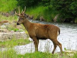
The Chilean Aysén region is located in the south of Chile in the Patagonia region. This area is known for its diverse ecology including the many unique flora and fauna. This includes a diverse variety of endemic species that face a serious threat if the project were to ensue. The Huemul deer is a currently endangered species located in the southern Patagonian region that would be critically effected by the dams, possibly facing extinction. The Huemul deer is a symbol on Chile’s National Coat of Arms and serves a great importance to the culture. It is one of the rarest animals in Chile and is also known at the South Andean deer, due to its residence in this area.
Additionally, the two rivers selected to be built on are characterized by high flow rates and low variation compared to the other rivers in the region. Both the rivers initiate from the glacial bodies, the Northern Ice Field and the Southern Ice Field.
5. ActorsThere are many actors involved in this project including the companies who jointly own HidroAysén, Endesa and Colbun S.A., the Chilean government, the general population of Chile and the local people who would be affected or displaced by the construction of the dams. It is apparent that even within the government there is a difference in opinions on the necessity of the project. In 2013, presidential front-runner, Michelle Bachelet, made a public statement denouncing the construction of the dams. This goes directly against President Pinera’s approval of the project in 2011. As of yet, the majority of the Chilean people have spoken out vehemently against the project due to the environmental impact it will have as well as the displacement of the local populations. They feel the country can look to other sources of energy rather than following through with such a impactful project. The owner of HidroAysén is a joint venture between Endesa a subsidiary of Italian conglomerate ENEL, and the Chilean company, Colbun S.A,. Endesa owns 51% of the project while Colbun S.A. accounts for 49%. Despite this international influence, the conflict is mainly of a civil nature. The Chilean government feels the dams are necessary in order for Chile to meet its growing energy needs as it continues to develop and industrialize. The environmental activists in the country oppose this construction, as there have been estimates that the project will flood around 14,579 acres of natural reserves in the area and possibly destroy much of the well-revered characteristics of the land. The local populations are strongly against this construction due to possibility of the displacement of their homes as well as the damage it could cause to their essential resources such as the rivers.
II. Environment Aspects
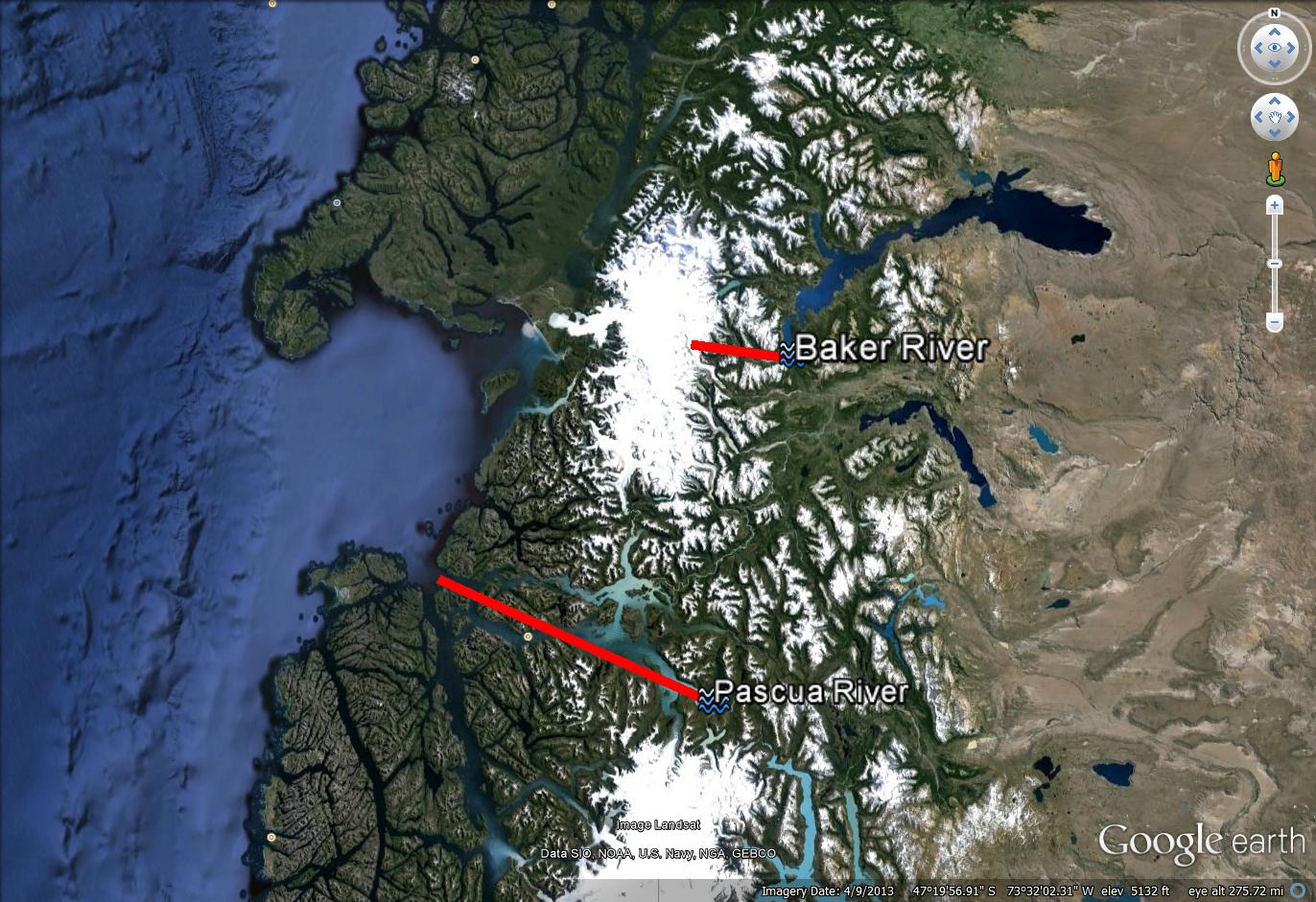
6. Type of Environmental ProblemGeography plays an important role in this Patagonian case study, since it is located in such a remote area. Located at the southern tip of the longest country in the world, Chile, these proposed dams would have a significant impact on the diverse ecosystem currently existing in the area. Both the Baker and Pascua Rivers share a common mouth, a major glacier located to the east of the Pacific Ocean. This map outlines with the path feature how the rivers are connected to the glacier and where they flow (see figure 2).
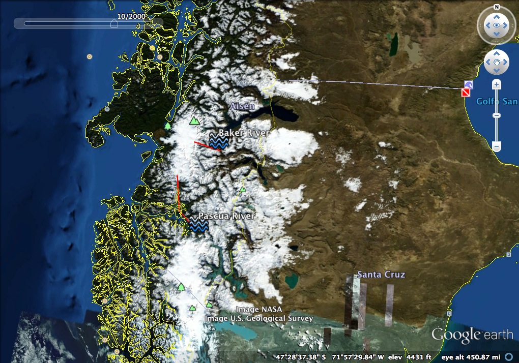
Figure 2: Patagonia Glaciers and Rivers It is clear from figure 2 that if the main glacier were to shrink, there would be a significant impact on the flow of water to these two rivers. Hence, if global warming caused the glacier to melt more rapidly, the rivers would face an alternation in their composition and flow levels. Furthermore, the proposed dam project would need to consider these possibilities when determining the benefits and costs of the project. A major sign of this possible glacial melting can be seen from satellite images of the same area from 1969 versus the area now (see Figure 3). In figure 3 there is a significantly greater amount of ice and snow cover than in figure 2. This is concrete evidence of the existence of glacial melting, and a good prediction of what will come in the future. As global warming continues, the glacier will continue to shrink, until there is no longer a source for the rivers.
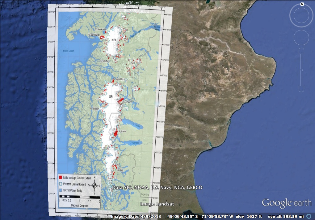
Figure 3: Patagonian region in 1969 7. Type of HabitatMuch of the habitat surrounding these rivers is characterised by the glaciers that support it. There are many unique flora and fauna in the area, including the endangered Huemul deer mentioned earlier. 8. Act and Harm Sites:Figure 4 shows the extent of horizontal glacier recession around North and South Patagonian Icefields (NPI and SPI) since AD 1870. The overlay map was created by comparing digitized shapefiles of LIA glacier extent to digitized shapefiles of contemporary glacier extent for 270 outlet glaciers of the SPI and NPI. This rapid melting is a trend that could significantly impact people’s water supplies as well as the project to build the dams. As these glaciers melt, the impact will both affect the environmental composition of the area and the worth of the dams. Without these glaciers, the source of the Baker and Pascua rivers will be gone, and hence the dams will be deemed useless. Billions of dollars and irreconcilable harm to local populations will have ensued for very little reason. Hence, it is important to consider this possible glacial melting before HidroAysen follows through with the dam project.
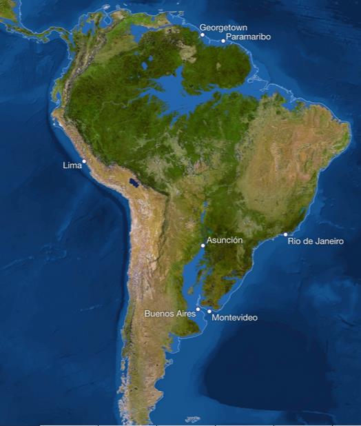
Figure 4: glacial retreat According to the IPCC assessment of projected climate change for South America, all of South America is expected to warm during this century. Annual precipitation is likely to decrease in the Southern Andes, with relative precipitation changes being largest in summer. Due to the mountainous landscape of the region, changes in atmospheric circulation may induce local variability in precipitation for these regions. In the winter months, precipitation will likely increase at the southernmost point of the continent, Tierra del Fuego, and in the summer it will increase in the southeastern regions. Due to the existence of numerous glaciers in the region, it is likely that melting ice will prove to be an issue by 2030 for these countries. Figure 5 below from National Geographic shows how South America would look if all the ice on land melted and drained into the sea, raising sea levels by 216 feet and creating new shorelines for the continents and inland seas. The border around the continent represents the current borders. Figure 5 shows major major cities in South America such as Buenos Aires and Montevideo being completely submerged by 2030. This would have dire consequences for the population as they would need to relocate, costing millions of dollars and tremendous uncertainty.
Figure 5: Predicted Sea Level Rise Consequences
III. Conflict Aspects
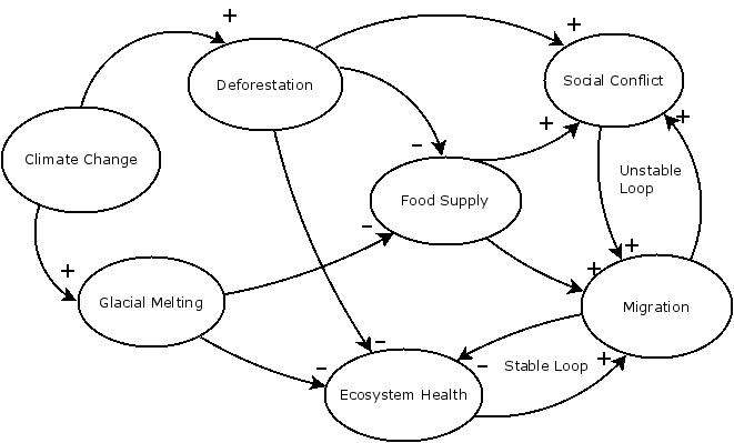
9. Type of Conflict: IntrastateThe Hydroelectric dam projects will have a direct impact on the local communities around the rivers and the Chilean community. 10. Level of Conflict: LowAlong the regions where the Andes mountain range exists there is an abundance of glaciers. Due to global warming, the glaciers in this region are expected to experience significant melting. The disappearance of these glaciers could result in the drying of certain rivers, such as the Baker and Pascua, which serve as lifelines for many local communities. As people are forced to migrate due to climate change, this creates the possibility for conflict. The casual loop diagram below in figure 6 outlines the effect of climate change on both the environment and social factors. In this diagram, a stable loop appears between increased migration leading to the further deterioration of the ecosystem health. An unstable loop, however, exists where social conflict and migration affect each other. As more migration occurs, social conflicts will escalate, and lead to further migration as communities are displaced. Overall, this diagram shows the complexity of the issue of climate change, and how many different factors come into play in this intertwined conflict.
Figure 6: Glacial Melting Causal Loop Diagram 11. Fatality Level of Dispute (military and civilian fatalities)There is the possibility for civilian fatalities if the conflict escalates, as people are forced to migrate or protests turn violent.
IV. Environment and Conflict Overlap
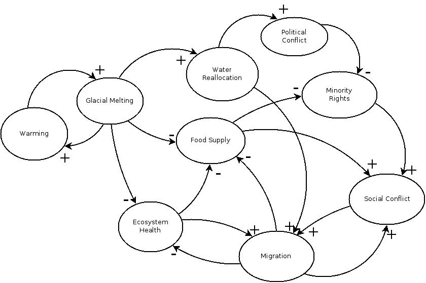
12. Environment-Conflict Link and Dynamics:In causal loop diagram below (Figure 7), there are multiple stable and unstable loops. The main reinforcing loop exists between warming and glacial melting, where both have positive effects on each other. This results in an exponential increase in the climate change of the Patagonian region. Overall, this loop diagrams how warming will lead to more glacial melting of the glaciers that lead to the rivers where the dams are posited to be built. This has the potential to deplete the food supply and ecosystem health of the Patagonian region, included the aforementioned Huemul deer. This will then lead to more migration due to the lack of food. Another reinforcing loop exists between social conflict and migration, as both will exponentially increase the other. As more people are forced to relocate or migrate due the dams' influence on their community, the people will disrupt others' way of life when they settle in new areas. The glacial melting will also lead to an increase in water reallocation, as there will be less water in the rivers, which could lead to more migration and more political conflict as disputes over who receives the water arise.
Figure 7: Causal Loop Diagram 13. Level of Strategic Interest: RegionalThe dam project already affects the entire country of Chile due to an energy need on a national scale. While the local populations living around the region of projected construction are the only ones who will be initially displaced and directly effected, there will be an indirect effect on societies that are forced to accomodate these new migrants. The consequential environmental effects of the dam construction will also have regional-level effects for the rest of the nation. 14. Outcome of Dispute: In ProgressIf HidroAysen is allowed to continue construction again the protests amongst civilians will flare up again and conflicts will escalate.
V. Related Information and Sources
15. Related ICE CasesThe following cases represent similar types of dam related conflicts in different regions of the world. These cases also show the negative environmental impacts of building dams on rivers and the effect on the local populations residing in the area.
16. Relevant Websites and LiteratureIPCC. “Climate Change 2007: Working Group I: The Physical Science Basis.” IPCC Fourth Assessment Report. 2007. Web. Nov. 14, 2013. <http://www.ipcc.ch/publications_and_data/ar4/wg1/en/ch11s11-6.html> “World Population Prospects.” Population Division, Population Estimates, and Projections Section. United Nations Department of Economic and Social Affairs, 2012. Web. 15 Nov. 2013 <http://esa.un.org/wpp/Excel-Data/population.htm> Global Economic Prospects. “Latin America and the Caribbean Region.” The World Bank. June 2013. Web. Nov 14, 2013. UNDP. Understanding Social Conflict in Latin America. Brief Report, La Paz: March 2013. Web. Nov 14, 2013. <http://www.undp.org/content/undp/en/home/librarypage/crisis-prevention-and-recovery/Understanding-Social-Conflict-in-Latin-America>Image Sources: Glasser, Neil. April 9, 2011, Photography. Simple Climate. Accessed October 17, 2013. <http://simpleclimate.wordpress.com/2011/04/09/patagonian-survey-reveals-tenfold-glacier-melt-speed-up/> PHILIPPE HUYBRECHTS, VRIJE UNIVERSITEIT BRUSSEL; RICHARD S. WILLIAMS, JR., WOODS HOLE RESEARCH CENTER; JAMES C. ZACHOS, UNIVERSITY OF CALIFORNIA, SANTA CRUZ; USGS; NOAA, ETOPO1 BEDROCK, 1 ARC-MINUTE GLOBAL RELIEF MODEL COPYRIGHT © SEPTEMBER 2013 NATIONAL GEOGRAPHIC SOCIETY
|
