1. Abstract
Zambia is already beginning to feel the effects of climate change in the form of higher temperatures and an increase in frequency of droughts and floods. Deforestation has also been an ongoing problem in the country with 250,000 hectares of forest being lost every year. In combination, these effects reduce crop yield and worsen the lives of the majority of Zambian people who depend on agriculture. These detrimental environmental consequences run the risk of increasing competition for arable land as well Zambia's rich mineral reserves as people search to improve their livelihoods and secure sources of revenue. As a way of preventing this potential competition from developing into violent conflict, a peace park named the Kavango-Zambezi Transfrontier Conservation Area has been established in the Southern Africa region in order to encourage resource sharing and cooperation. Furthermore, the United Nations, in collaboration with the Peace Parks Foundation, has agreed to implement a Reduced Emissions from Deforestation and Forest Degradation (REDD) initiative in the Zambian portion of the park which is intended to promote the preservation of forest as well as provide an alternative revenue stream.
2. Description
Establishment of the Kavango-Zambezi Transfrontier Conservation Area
Peace parks as a concept are intended to serve as conservation zones which promote cooperation and sustained peace. As Saleem H. Ali, the editor of Peace Parks: Conservation and Conflict Resolution, writes, "the main premise of environmental peacemaking is that there are certain key attributes of environmental concerns that would lead acrimonious parties to consider them as a means of cooperation. Thus environmental issues could play an instrumental role even in cases where the conflict does not involve environmental issues."1 In the spirit of environmental peacemaking, the Peace Parks Foundation was established in 1997 in order to manage and fund conservation areas straddling borders. The founders of the Peace Parks Foundation envisioned peace parks as “mechanisms for promoting regional cooperation and human development, reducing the prospects for interstate conflict and contributing directly to the economic development of local communities that would benefit from tourism and resource harvesting.”2
Since then that vision has come to fruition as many peace parks have been established around the world in formerly conflict prone areas. The park that is the focus of this case study is the Kavango-Zambezi Transfrontier Conservation Area, also known as the KAZA TFCA or KAZA Park. A map detailing KAZA Park's borders is displayed below.
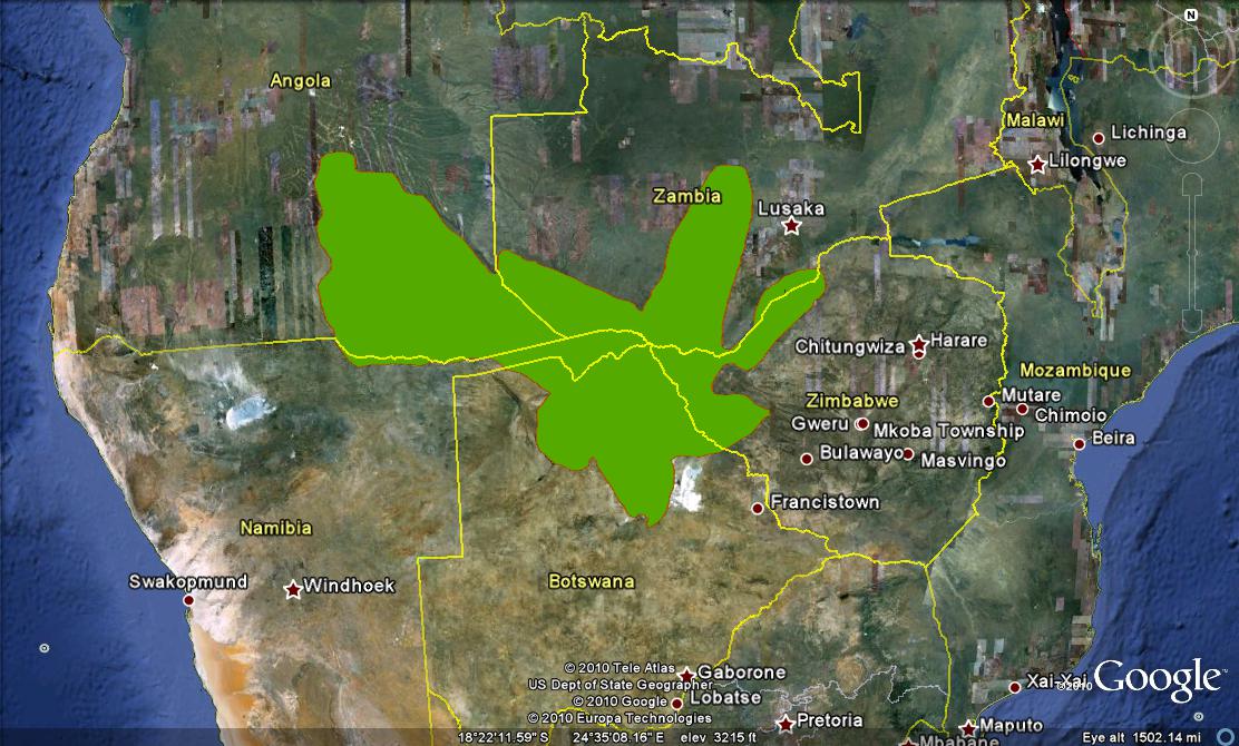
Figure 1: Boundaries of KAZA Park
As is clear from the map, the park is vast in size. It covers approximately 278,132 square kilometers, analogous to the size of Italy, and touches on the countries of Angola, Namibia, Botswana, Zimbabwe and Zambia.3 KAZA Park was created by consolidating thirty-six national parks, game reserves, wildlife management areas and community based conservancies, in addition to the Okavango Delta and Victoria Falls, one of the seven natural wonders of the world.4
Deforestation
Deforestation and climate change are two environmental forces impacting Zambia. First, deforestation plays a key role because it is both a contributor to climate change as well as a potential source for mitigation through the generation of Reduced Emissions from Deforestation and Forest Degradation (REDD) credits. Deforestation in Zambia has been dramatic, with no primary forest left and 250,000 hectares lost each year.5 These high rates of deforestation occur because with many Zambians lacking access to electricity, both rural and urban households rely on woodfuel and charcoal to meet their energy needs. In fact, these sources account for 75-90% of the country's energy.6 The severity of deforestation in Zambia is represented in the following maps.
The first map, Figure 2, was generated using the “Disappearing Forests” layer on Google Earth which was derived using data from the United Nations Food and Agriculture Organization, the World Resources Institute, and Greenpeace. As is indicated by the key on the map, the height and color of each country are indicative of how many hectares were lost or gained in the time period of 1990 to 2005. Every single country surrounding KAZA Park lost forest cover during this time period. On the original “Disappearing Forests” layer in Google Earth, each country has an associated pie graph with more specific deforestation data. Zambia alone saw its forest cover decline by 13.6% between 1990 and 2005 and Zambia no longer has any forest which exist in a frontier-forest state, meaning undisturbed forest areas which are large enough to support viable populations of their biodiversity. As is displayed on the map, Zambia is surpassed only by the Democratic Republic of Congo in terms of total hectares deforested.
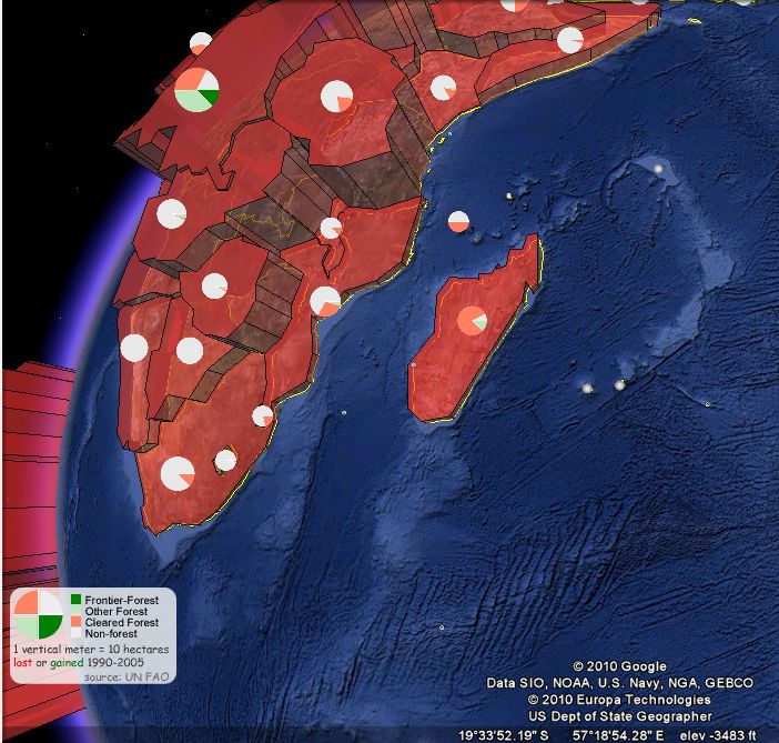
Figure 2: Disappearing Forests in Southern Africa
The following map focuses more specifically on Zambia, particularly on the region where the REDD project will be implemented. This map was derived by applying the “Forest Cover Change (2000-2005)” layer in Google Earth and shows the boundary of KAZA Park with a brown outline. The map displays only the time period 2004-2005 so that we can see that even in one year alone, substantial reductions in forest cover occur in Zambia. Forest cover change is color coded, with reductions in forest cover represented on a scale of 0% to 100% with light orange representing low reduction all the way up to deep red representing high reduction. As can be seen in the map, the area around the Zambian portion of KAZA Park sees fairly heavy reductions in forest cover even over the course of a year. The REDD program is aimed at impeding these reductions.
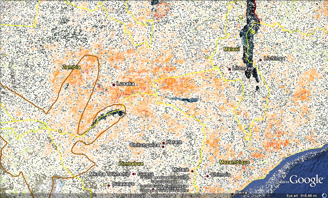
Figure 3: Forest Cover Change 2004-2005
The protection of forests is cricial in Zambia not only for environmental reasons, but for economic reasons as well. Forests and woodlands are beneficial for the ecosystem and agricultural productivity because they are useful in "protecting catchment, purifying water and regulating river flows, which in turn ensure the supply of water to support wildlife and community livelihood."7 In addition, the forest sector contributes significantly to the gross domestic product of Zambia through the export of timber and the creation of employment in surrounding communities. However, only 15% of each tree is marketed as timber, leaving 85% of each sawn tree wasted which results in many more trees than necessary being cut down.8
Climate Change
Climate change is beginning to be felt in Zambia, with mean annual temperatures in the country increasing by 1.3°C since 1960.9 Consequently, these higher temperatures have increased the frequency of warm nights and days, which is detrimental to crop yields in a tropical environment such as the one in Zambia. Furthermore, a report produced in 2007 by the Zambian government, titled National Adaptation Program of Action, asserts that "droughts and floods have increased in frequency, intensity, and magnitute over the last two decades" due to climate changes.10 These deviations from the climatic norm further exacerbate reductions in crop yield. As Catherine Namugala, the Zambian Minister for Tourism, Environment, and Natural Resources explains, "[a]ny change in climate spells disaster for Zambia because the majority of the Zambian people depend on agriculture."11 A full 85% of the Zambian work force is involved in agriculture.12
With reductions in crop yields and viable arable land, the combination of deforestation and climate change in Zambia increases the risk of competition over increasingly scarce resources. As yields are reduced and land becomes less fertile, laborers could be pushed off the land in search of better livelihoods. This could cause tensions with those lucky enough to still be in control of productive agricultural land. Furthermore, Zambia contains a wealth of natural mineral resources and competition over these may arise as well as agriculture becomes less profitable and less attractive. Zambia contains 6% of the world's copper reserves and is a major producer of emeralds, aquamarines, amethyst, and tourmalines.13 If demand for these commodities continues to rise, driving up their prices, the possession or access to these resources stands to become very lucrative and could incite conflict over who controls them.
Solutions Forward
Yet both the issue of deforestation and climate change are beginning to be addressed in Zambia. In June of 2009, Zambia’s permanent secretary of the Ministry of Tourism, Environment, and Natural Resources, in collaboration with the CEO of the Peace Parks Foundation, signed a memorandum of understanding to implement a climate change project in an area of Zambia that is a part of KAZA Park.14 The project will consist of the following two components: 1) "the development of land-use change activities on the ground (avoided deforestation, forest rehabilitation and fire management) that will provide benefits to local communities through alternative livelihoods and income streams, as well as private sector investment and employment opportunities and 2) the development of a financial vehicle that will ensure the inclusive, transparent sale of generated carbon offsets and the flow of generated income streams to deserving parties on the ground."15
The goal of the Climate Change Unit of the Peace Parks Foundation, who is overseeing the project, is "to assist host countries to provide an economic driver that reduces deforestation, restores degraded areas and provides alternative livelihoods for communities."16 The project is a part of the United Nations' Reduced Emissions from Deforestation and Forest Degradation (REDD) initiative. It intends to mitigate climate change by reducing deforestation rates through the generation of credits which are earned through avoided deforestation. These credits can then be traded on the carbon market, therefore incentivizing the preservation of forests and discouraging carbon emissions. The REDD project also aims to invest in value-addition of forestry products so that more revenue is generated from each tree and non-timber products are produced from the leftover wood which can be certified and sold as goods from sustainably managed forests.17
3. Duration
Begin Year: 2020
End Year: 2050 and Beyond
Duration: 30+ Years
While KAZA Park has only recently been established and is intended to alleviate conflict, any conflict that may result from climate change induced competition over resources is likely to occur in the upcoming decades. Only in the decades leading up to the middle of the 21th century will the negative impacts of climate change be felt powerfully enough to incite any sort of violence over natural resources.
4. Location
Continent: Africa
Region: South Africa
Country: Zambia
5. Actors
United Nations
Peace Parks Foundation
Zambian National Government
Zambian Agricultural Workers
6. Type of Environmental Problem
Deforestation
Climate Change
7. Type of Habitat
Tropical
8. Act and Harm Sites:
Conflict Harm Site: Zambia
Act Site: Global (Climate Change) and Zambia (Deforestation)
Zambia is at the nexus of two environmental problems: climate change and deforestation. While climate change was and continues to be caused almost exclusively outside of Zambia's borders, the population of Zambia still faces some of the repercussions of climate change, namely higher temperatures and increases in severe weather events such as droughts and floods which reduce crop yields. Deforestation, on the other hand, is a more localized problem which also depresses crop yields since forests serve as a means to retain and purify rainfall and ensure it flows at a steady rate.
9. Type of Conflict
Civil
If competition over Zambia's mineral wealth and arable land materializes, Zambia risks succombing to the civil strife many of its neighboring countries have experienced.
10. Level of Conflict
Resource Access
11. Fatality Level of Dispute (military and civilian fatalities)
Low
Zambia has not had a particularly violent history and the risk of civil conflict resulting from climate change can be reduced through adaptation measures. The establishment of the UN REDD program in the Zambian portion of KAZA Park, as well as the National Adaptation Program of Action (NAPA) developed by the Zambian government in 200718serve as the first steps in this process.
12. Environment-Conflict Link and Dynamics:
The causal loop diagram below depicts the key factors at play in the intersection of climate change, deforestation, and conflict in the Kavango-Zambezi Transfrontier Conservation Area. The diagram can best be understood if beginning with either international conflict or climate change as the starting point. For example, starting on the left hand side of the diagram with international conflict, this factor serves as the impetus for establishing peace parks such as KAZA Park. There is a positive direct correlation between international conflict and KAZA Park (specifically, its establishment) because it was the concepts of environmental peacemaking and cooperation over shared resources that gave rise to the idea of peace parks.
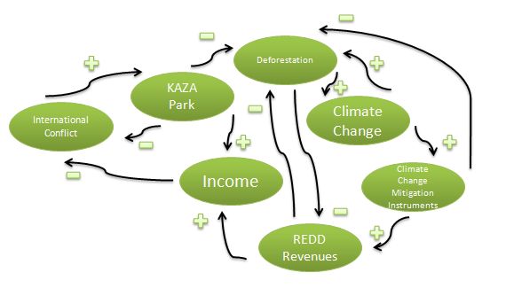
The region surrounding KAZA Park, and particularly some of the countries the park extends into, have had turbulent and violent histories yet KAZA Park can act as an incentive for cooperation among the civil society members of these nations by allowing them to jointly manage resources as well as provide alternative revenue streams. The notion of KAZA Park reducing the potential for conflict in the surrounding area is thus demarcated by the arrow with a negative sign going from KAZA Park to international conflict, indicating an inverse relationship.
The other factors in the diagram relate specifically to the portion of KAZA Park located in Zambia. The REDD program essentially offers payments to locals to not cut down their forests since these forests contribute to climate change mitigation by absorbing carbon from the atmosphere. Conversely, cutting them down releases carbon dioxide, thus exacerbating the problem of climate change.
As can be seen on the right side of the diagram, climate change mitigation instruments such as REDD have come about due to the fact that we better comprehend the complexities behind climate change and it is becoming blatantly clear that climate change is not going to solve itself unless we implement tangible action. Thus, the international community has devised policies and policy instruments to address climate change, one of them being REDD. By incentivizing locals in Zambia to preserve their forests, revenues will be generated which will not only increase the income levels of the locals, but will also curtail deforestation, as depicted in the diagram. The incentives necessary to encourage such behavior will include conservation agriculture initiatives which will reduce conversion of forest land to agricultural land and value addition to existing timber and non-timber forest products.19 Heightened income levels, as well as the continued success of KAZA Park, are likely to reduce chances for violent conflict within Zambia as well as in the region since the locals surrounding the park will have incentives to cooperate.
13. Level of Strategic Interest
Substate
Region
Conflict over limited resources in Zambia would be present on the substate level as differing groups would compete in order to preserve their livelihoods. Yet considering the high rates of displacement and migration in the Southern Africa region as a whole, any conflict that would occur in Zambia may spill over into the rest of the region.
14. Outcome of Dispute:
In-progress
15. Related ICE Cases
No. 52 DMZ: Korean Demilitarized Zone As a Bioreserve (1998)
The demilitarized zone between North and South Korea that was established in 1953 to serve as a buffer between the two nations has flourished as a refuge for hundreds of animal and plant species.
No. 54 HAITIDEF: Deforestation in Haiti (1997)
Since Haiti is one of the poorest nations in the world, it has experienced deforestation on a large scale as land is cleared to accomodate rising populations and increased demand for agricultural land.
No. 88 CONGO-COLTAN: Congo War and the Role of Coltan (2001)
One of the factors contributing to the conflict in the Congo is competition over the mineral of coltan, which has become highly lucrative as it is used in products such as cell phones and computer chips.
No. 129 CABINDA: Cabinda Enclave in Angola, Oil and Conflict (2004)
The portion of Angola known as Cabinda has experienced great political turmoil as well as environmental degradation due to its high oil exports.
No. 219 CENTRAL-AFRICAN-REPUBLIC: Central African Republic (2010)
Climate change has already induced increased desertification, and therefore limited arable land, which has resulted in riots and increased membership in military groups due to food shortages.
16. Relevant Websites and Literature
1. Saleem H. Ali, “Introduction: A Natural Connection Between Ecology and Peace?” in Peace Parks: Conservation and Conflict Resolution, ed. Saleem H. Ali (Cambridge: The MIT Press, 2007), 3.
2. Dan Henk. 2008. Human and Environmental Security in Southern Africa: The Kavango-Zambezi (KAZA) Transfrontier Conservation Area Project. (San Francisco: 49th Annual ISA Convention), 14.
3. KAZA Park TFCA Southern Africa Game Reserve. 2010. “Kazapark.com: A World Without Borders.” [Cited 26 October 2010]. Available from World Wide Web: <http://www.kazapark.com/>.
4.
Dan Henk. 2008. Human and Environmental Security in Southern Africa: The Kavango-Zambezi (KAZA) Transfrontier Conservation Area Project. (San Francisco: 49th Annual ISA Convention), 15.
5.
OneWorld UK. 2010. "Climate Change in Zambia Briefing." [cited 27 October 2010]. Available from World Wide Web: <http://uk.oneworld.net/guides/zambia/climate-change>.
6. Ibid.
7.
Peace Parks Foundation Climate Change Unit. 2010. Climate Change Programme Concise Overview. (Stellenbosch, South Africa: Peace Parks Foundation), 6.
8. Ibid.
9.
OneWorld UK. 2010. "Climate Change in Zambia Briefing." [cited 27 October 2010]. Available from World Wide Web: <http://uk.oneworld.net/guides/zambia/climate-change>.
10. Ibid.
11. Ibid.
12.
CIA World Factbook. 2010. "Zambia." [cited 21 November 2010]. Available from World Wide Web: <https://www.cia.gov/library/publications/the-world-factbook/geos/za.html>.
13.
KAZA Park TFCA Southern Africa Game Reserve. 2010. "Kazapark.com: A World Without Borders>Zambia." [cited 27 October 2010]. Available from World Wide Web: <http://kazapark.com/Zambia/>.
14. Peace Parks Foundation. 2010. Peace Parks News: Climate Change MOU Signed for Zambian Component of Kaza TFCA [online]. [cited 30 August 2010]. Available from World Wide Web: (http://www.peaceparks.org/News_1090000000_21_0_0_0_804_Climate+Change+Programme+TFCA+Climate+change+MoU+sig....htm).
15. Ibid.
16.
Peace Parks Foundation. 2010. Climate Change Programme Concise Overview. Stellenbosch, South Africa: Peace Parks Foundation, 2.
17. Ibid, 7.
18.
OneWorld UK. 2010. "Climate Change in Zambia Briefing." [cited 27 October 2010]. Available from World Wide Web: <http://uk.oneworld.net/guides/zambia/climate-change>.
19.
Peace Parks Foundation. 2010. Climate Change Programme Concise Overview. Stellenbosch, South Africa: Peace Parks Foundation, 6.
Figure 1: Google Earth. "KAZA Park Polygon." [cited 22 November 2010].
Figure 2: Google Earth. "Disappearing Forests." United Nations Food and Agriculture Organization. [cited 22 November 2010].
Figure 3: Google Earth.
“Forest Cover Change (2000-2005).” MODIS Vegetation Continuous Fields Tree Cover Change. [cited 22 November 2010].
Zambian Flag: CIA World Factbook. 2010. "Zambia." [cited 21 November 2010]. Available from World Wide Web: <https://www.cia.gov/library/publications/the-world-factbook/geos/za.html>.
[© 13 December 2010 oana.leahu [at] gmail.com]