| ICE Case Studies
|
by Julia Rotondo |
I.
Case Background |
This case study describes the possible future conflict threats in the Arctic as a result of climate change induced Arctic Sea ice melt. Recent events suggest that the faster than expected melting will lead to conflict as competition for newly exposed sea and shipping lanes intensifies in the coming years. However, the Ilulissat Declaration, signed by the major powers with territorial claims in the Arctic, suggests that soft power - or creating international regimes and cooperative action - may provide an alternative pathway to violence.
Climate change is more apparent in the Arctic than almost any other location on Earth. Change in the Arctic is driven not only by rising global temperatures, but also from Arctic specific feedback loops. Small increases in temperature - only a fraction of one degree - can transform reflective sea ice (which reflects solar radiation from the sun back into outer space and thus contributes to global cooling, a phenomena known as the albedo effect) into open-sea water. [1] Arctic Sea ice is the "primary means by which the Arctic exerts leverage on global climate, and sea-ice extent has been decreasing"[2].
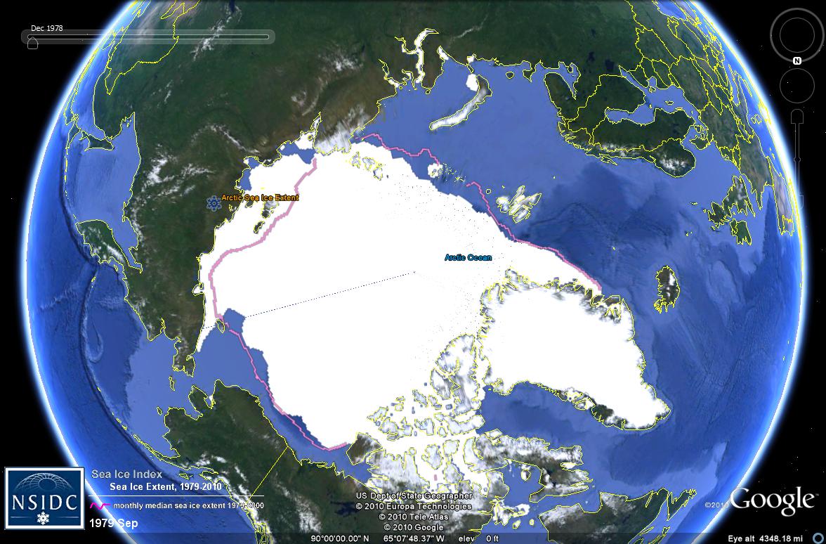
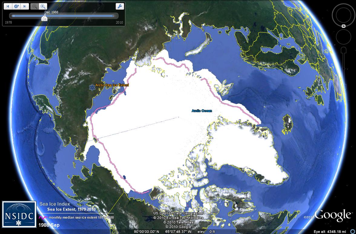
Arctic Sea ice has declined by between 15 and 20 perfect over the last forty years; 2007 proved to be a landmark year for sea-ice extent decline, more than one million square miles of sea ice melted.[1] Though sea-ice extent has recovered slightly in the years since that historical low, trends still indicate a general melting trend. The following maps demonstrate this trend. Each map is from a different decade in (1978 to 2008) taken during the month of September, generally when arctic sea ice retreat is greatest. The pink line demarcates the median monthly sea ice extent from 1979 to 2000; while the first two maps show the sea ice roughly in line with median sea ice extent, that last two graphs show a new trend of retreating sea ice extent, most pronounced in 2008. (See Figures 1-4 below)
Figures 1-4: Changes in Arctic Sea ice Extent from September 1979, September 1988, September 1998, to September 2008
In the 2008 graph, an obvious retreat in Arctic Sea ice extent can be seen off the Russian coast. One of the biggest drivers of the melting ice by Russia has been black carbon from air pollution in South Asia, and particularly from China. Black carbon, an aerosol, is created from multiple industrial and agricultural processes - smokestacks, tailpipes, and forest fires (both natural and man made). While the aerosol can reflect incoming solar radiation while in the atmosphere, it holds huge global warming potential when it lands on snow. [3] White snow create a global albedo effect, which reflects incoming solar radiation and works as a global cooling force; however, when black soot molecules land on white snow, they decrease the albedo effect - a net global warming force. With the industrialization in China starting in the early 1990s and continuing with high GDP growth for much of the last decade, it is unsurprising that its carbon emissions have increased.
Sea ice extent retreat has not been limited to the month of September, however. Throughout the second half of the decade, Arctic Sea ice extent has been below average, sometimes significantly below the 1979-2000 average, year round. The following diagram compares sea ice extent from five months (June through August) of 2005, 2007, 2008, 2009, and 2010 with the average sea ice extent from 1979 to 2000 (with a standard deviation to show normal variation). It becomes immediately clear that not only has current sea ice extent shrunk dramatically from historic averages during high melt season in September, but also that sea ice extent has shrunk in every month the data examines. (See Figure 5 below)
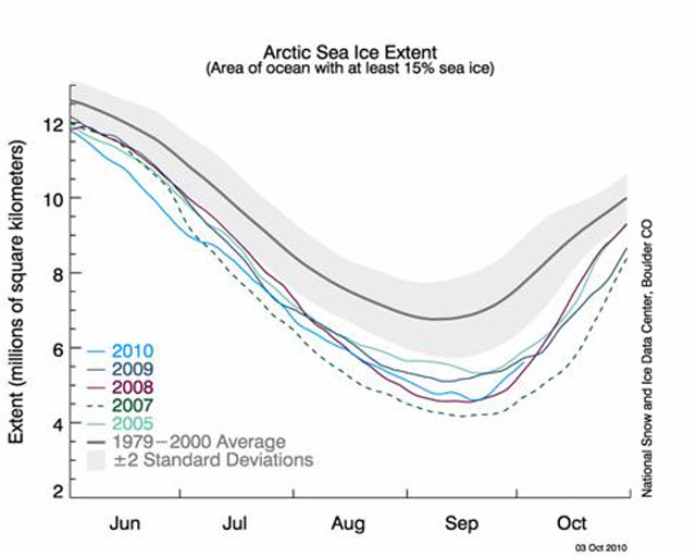
Figure 5: Arctic Sea Ice Extent Comparison
With the Arctic landscape rapidly changing, questions of legal claims, borders, and ownership have become more important than ever. With more and more of the Arctic covered by open ocean rather than sea ice, nations are realizing the economic opportunities to be found. With less sea ice, the long sought after "Northwest Passage" has suddenly become a possibility rather than a myth, and without thick sea ice, drilling for projected oil and natural gas reserves becomes less expensive and dangerous.
Currently, 10 percent of the world's known conventional petroleum reserves are accounted for within Arctic fields in Canada, Russia, and the United States. A 2008 geological survey estimated that the Arctic might also have reserves equally approximately 13 percent of the world's undiscovered oil and approximately 30 percent of the undiscovered natural gas. A majority of these reserves are estimated to be offshore. [4] As Arctic ice melts, it becomes increasingly easy to access and extract these resources.
The Arctic Council, a body comprised of the nations that border the Arctic Circle, convened a conference in Ilulissat, Greenland in late-May 2008 to discuss climate change, the Arctic Ocean, the protection of the marine environment, maritime safety, and the division of emergency responsibilities should new shipping routes and tourism opportunities be opened. On May 28, 2008 the Ilulissat Declaration was announced. The short declaration noted the changing Arctic environment and affirmed the United Nations Convention on the Law of the Sea (UNCLOS) as the main legal regime of the region. The Ilulissat Declaration argues that:
"the law of the sea provides for important rights and obligations concerning the delineation of the outer limits of the continental shelf, the protection of the marine environment, including ice-covered areas, freedom of navigation, marine scientific research, and other uses of the sea. We remain committed to this legal framework and to the orderly settlement of any possible overlapping claims." [5]
It is noteworthy to mention that only Denmark, the United States, Russia, Norway, and Canada were signatories to the Ilulissat Declaration. Sweden, Finland, and Iceland were not invited to the conference nor have they signed on, mainly due to the fact that while they are Arctic nations they have no real claims to the Arctic itself. Indigenous people were also excluded from the conference and had no input into the Declaration's contents nor have any indigenous groups signed on.
UNCLOS was adopted in 1982 to replace four other maritime treaties first codified in 1958 and entered into force in 1992. UNCLOS defines the rights and responsibilities of nations in using the worlds' oceans. It also establishes guidelines for businesses, environmental protections, and the management of marine natural resources. In the context of the Arctic, the most important provision of UNCLOS is its creation of exclusive economic zones (EEZs).
An EEZ gives a coastal nation the sovereign rights for the "purposes of exploring and exploiting, conserving and managing the natural resources... of the waters superjacent to the seabed and of the seabed and its subsoil, and with regard to other activities for the economic exploitation and exploration of the zone". [6] The zone is measured from a nation's coastal baseline to a distance of 200 nautical miles, with the only exception being when EEZs might overlap (i.e. coastal baselines are less than 400 nautical miles apart). In the event of an overlap, it is up to the nations to come to an agreement on the boundary. States also have the rights to the seabed of the continental shelf up to 350 nautical miles from the coastal baseline beyond their EEZ.
One major problem with the Ilulissat Declaration affirming that UNCLOS would govern the Arctic Ocean is that the United States is not a signatory to the Convention, and thus not constrained or governed by the same rules as the other signatories (Russia, Denmark, Norway, and Canada).
C. LAND GRABS
After ratification of UNCLOS, a nation only has ten years to make a claim on the seabed of the continental shelf to create their EEZ and extended claim area. While the United States has not yet ratified UNCLOS, the other Arctic nations have: Canada in 2003, Russia in 1997, Denmark in 2004, and Norway in 1996. [7] After a Russian submarine planted a flag on the Arctic seabed in 2007, international fears of land grab in the Arctic arose. It should be noted, however, that Russia has the largest claim in the Arctic by far due to its large coastline. Further, the flag was planted along the Lomonosov Ridge, an area already considered by the Russians to be Russian territory.
The figure below shows the competing claims between the five arctic nations and the areas of contention. The red dotted line shows the 200-mile line marking each nation's EEZ; however, the middle area around the North Pole is beyond that 200-mile boundary. The map highlights the Lomonosov Ridge, an underwater ridge that is a part of the continental shelf in the Arctic. Russia claims that this landmass is an extension of the Russian continental shelf, which would expand the Russian EEZ claim in the Arctic considerably if accepted by UNCLOS.
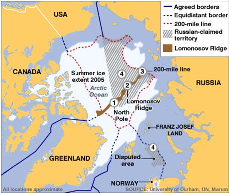
Figure 6: Russia's Arctic Claim based on the Lomonosov Ridge
Currently, the UN Commission has yet to decide on Russia's claim to the Arctic based on the Lomonosov Ridge.
ON-GOING: 2007- present
On August 3, 2007 a Russian exploration mission comprised of a nuclear-powered ice-breaker, research vessel, and two mini-submarines planted a Russian flag on the Arctic seabed claiming the region for Russia.[8] Though the planting of the flag had no legal strength, the act of planting the flag, and thus symbolically claiming the region (as some argued), ignited new worries of land grab and conflict over claims to the region across the world. These issues have not yet been resolved in any meaningful manner and remain ongoing.
Continent: Polar Region
Region: Arctic
Countries: Canada, United States, Russia, Norway, and Denmark.
National governments and militaries of Canada, United States, Russia, Norway, Denmark, and China
Indigenous peoples of the Arctic
The Arctic Council
The United Nations
Corporations involved in shipping, resource extraction
CLIMATE CHANGE
With the Arctic Sea ice melting, the most obvious environmental harm is to the species that depend on the Arctic ice for hunting and breeding, such as the Polar Bear, the Walrus, and the Ringed Seal. As Arctic Sea ice continues to melt, the albedo effect that it provides for the globe is reduced - leading to further habitat restriction of land-based Arctic animals such as lemmings, caribou, reindeer, and snowy owls.
With increased oil exploration and extraction, the impact on marine Arctic species is likely to be high. In a best-case scenario, there will never be an oil spill in the region and the largest impacts on marine and land species comes from the creation of infrastructure to transport oil (i.e. roads, oil pipelines, and drilling rigs). In a worst-case scenario, an oil spill such as the Gulf Oil Spill of April 2010 occurs - only without relatively easy access to the site - and oil and oil-dispersant chemicals are spilled into the Arctic Sea, which will severely disrupt the eco-system.
COLD
All the habitats within the Arctic will be impacted, whether land, sea, or ice.
DEVELOPED COUTNRIES AND ARCTIC AREAS
Specifically the Arctic Sea, Canada, United States, Russian, Norway, and Denmark will be harmed.
INTER-STATE
It appears extremely unlikely that inter-state war will break out between the Arctic nations over access and control over shipping lanes and oil resources as a result of Arctic Sea ice melt. Canada, Norway, the United State, Russia, and Denmark have partnerships and linkages in multinational institutions such as the United Nations, the North American Treaty Organization (excluding Russia), and the Arctic Council.
However, there has been growing concern over Chinese interest in the Arctic. The Russian military has publically singled out China for its "penetration" into the region to advance "their interests very intensively, in every possible way". [9] Admiral Vladimir Vysotsk stated that Russia will "not give up a single inch" of the Arctic, [9] a warning that does not preclude the possibility of conflict erupting between the two nations over natural resources and Russia's perceived violation of their territory by China. At the moment, however, nothing more than talk has resulted.
CIVIL
There are 4 million people living in the Arctic, of whom approximately 150,000 are indigenous people who have been living in the Arctic for generation without widescale interruption by outsider forces for generations. However, as Sheila Watt-Cloutier, an Inuit activist, argued, "As long as it's ice, nobody cares except for us, because we hunt and fish and travel on that ice. However, the minute it starts to thaw and become water, then the whole world is interested."[10] As groups rush to make their claims to increase exploration, the indigenous way of life will most likely be severely disrupted.
Further compounding the possibility of violence from indigenous peoples is that indigenous peoples are often excluded from the treaties that dictate how their homeland will be used. In fact, indigenous groups were not represented in the Ilulissat Conference, which does not bode well for their influence on legal regimes that govern the use of the region.
THREAT
Currently, the possibility of conflict is the largest concern rather than the actual outbreak of armed conflict over newly exposed resources and shipping lanes.
There have currently been zero fatalities from armed conflict in the Arctic region as a result of Arctic Sea ice melt.
INDIRECT
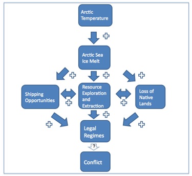
Global warming will change the Arctic landscape dramatically in the coming years. While global temperature is rising relatively slowly, temperature in the Arctic has been rising faster than expected. This gives policy makers less time to plan and negotiate for policy and legal regimes that will govern the area. As mentioned above, it appears extremely unlikely that inter-state conflict will occur due to global warming in the Arctic; however, should policymakers rush to create the policy and legal regimes for the area, low-level conflict may still occur due to uncertainties over ownership of seabed, access rights, or shipping route. Figure 7 (below) explains the possible routes to violence in the Arctic due to violence.
 \
\
Figure 7: Arctic Pathways to Conflict
The road to conflict begins with rising Arctic temperatures. The increase in Arctic temperatures has a positive relationship with Arctic Sea ice melt - the more the temperature increases the more Arctic Sea ice melts. This results in several simultaneous and often reinforcing processes. As the Arctic Sea is no longer covered in impenetrable ice, there are increased opportunities for exploration of natural resources and resource extraction, increased shipping opportunities through the Arctic, and the loss of native communities that survive due to the presence of year round sea ice. As mentioned previously, these processes can be positively reinforcing - as companies and nations explore the area for shipping routes they can also do exploratory work for resource extraction. As more land is dedicated to resource extraction, there will be fewer areas available to the native population for hunting or other activities.
With increased activities in the Arctic a need for legal regimes arises so that all nations, indigenous peoples, and corporations understand their property and access rights. In a way, this process has already occurred; the Arctic Council convened in 2008 in Ilulissat, Greenland to discuss how the Arctic would be governed in the face of climate change. At that point, significant Arctic Sea ice melt had been occurring and fears of land grab had been heightened with the Russian planting of their flag in the Lomonosov Ridge in 2007. Before the Ilulissat Declaration, it was unclear what international rules the Arctic nations would adhere to in the Arctic - how would land claims be established? What would happen in the case of competing claims? What international maritime laws would be followed?
The Arctic nations negotiated the Ilulissat Declaration to answer these question. However, as the last arrow in the diagram demonstrates, if legal regimes are weak, unclear, or impossible to enforce, then the possibility for future conflict still looms. Currently, it is unclear how effective the Ilulissat Declaration will be in preventing future conflict. Though it is unlikely large-scale inter-state war will break out in the region, the possibility for small-scale conflict continues, especially given the fact that the indigenous people of the region were not represented during the Declaration's negotiation. Though there are relatively few who live in the Arctic (approximately 4 million) and even fewer indigenous people (approximately 150,000 in Russia, Cananda, and the United States combined) [11], the Ilulissat Declaration is a sign of their lack of power - which can lead to violent consequences.
REGIONAL
ON-GOING
As global warming continues, the Arctic Sea ice will continue to melt and open new area to exploration for shipping and resource extraction, which leaves the potential for conflict in the Arctic open-ended for the foreseeable future.
[1] Beyers, Michael. Fall 2009. "Conflict and Cooperation: What Future for the Arctic?" Swords and Ploughshares. Vol XVII, No. 3, pp 18-21.
[2]. Huntington, H., G. Weller et al. November 2004. "Impacts of a Warming Arctic." Arctic Climate Impact Assessment. Pg 22.
[3] Bond, Tami. Testimony for the Hearing on Black Carbon and Climate Change, U.S. House Committee on Oversight and Government Reform 2-3 (October 18, 2007), available at http://oversight.house.gov/images/stories/documents/20071018110647.pdf
[4] United States Geological Survey, U.S. Department of the Interior. July 2008. "Circum-Arctic Resource Appraisal: Estimates of Undiscovered Oil and Gas North of the Arctic Circle."
[5] The Arctic Council. May 28, 2008. "The Ilulissat Declaration." Available at http://arctic-council.org/filearchive/Ilulissat-declaration.pdf
[6] United Nations Convention on the Law of the Sea. 1982. "Article 56". Part V: Exclusive Economic Zone. < http://www.un.org/Depts/los/convention_agreements/texts/unclos/part5.htm>
[7] United Nations Oceans and Law of the Sea, Division for Ocean Affairs and the Law of the Sea. "Chronological lists of ratifications of, accessions and successions to the Convention and the related Agreements as at 15 November 2010." Accessed 11/30/10 at <http://www.un.org/Depts/los/reference_files/chronological_lists_of_ratifications.htm>
[8] BBC News. August 2, 2007. "Russia plants flag under N pole." <http://news.bbc.co.uk/2/hi/europe/6927395.stm>
[9] The Telegraph. October 4, 2010. "Russian navy chief warns of China's race for Arctic." <http://www.telegraph.co.uk/news/worldnews/europe/russia/8041997/Russian-navy-chief-warns-of-Chinas-race-for-Arctic.html>
[10] Krauss, C. et al. October 10, 2005. "Arctic riches coming out of the cold." The New York Times. <http://www.nytimes.com/2005/10/10/health/10iht-web.1010arctic.complete.html>
[11] United States National Oceanic and Atmospheric Administration. "Frequently Asked Questions." Arctic Theme PageI. <http://www.arctic.noaa.gov/faq.html#8>
Figures:
Figure 1: "Arctic Sea Ice Extent: 1978". National Snow and Ice Data Center, Google World Layer. Map generated October 13, 2010.
Figure 2: "Arctic Sea Ice Extent 1988". National Snow and Ice Data Center, Google World Layer. Map generated October 13, 2010.
Figure 3: "Arctic Sea Ice Extent 1998". National Snow and Ice Data Center, Google World Layer. Map generated October 13, 2010.
Figure 4: "Arctic Sea Ice Extent 2008". National Snow and Ice Data Center, Google World Layer. Map generated October 13, 2010.
Figure 5: National Snow and Ice Data Center. October 3, 2010. "Arctic Sea Ice Extent."
Figure 6: "Russia's Arctic Claim." University of Durham, United Nations, Marum.
Figure 7: "Arctic Pathways to Conflict." Julia Rotondo, December 13, 2010.
© Julia Rotondo, December 13, 2010