Photo courtesy of earthobserver.org
Kisei Tanaka
ICE Case Studies
Number 270, December, 2011
I. Case Background
II. Environment Aspect
III. Conflict Aspect
IV. Env. - Conflict Overlap
V. Related Information
Abstract
|
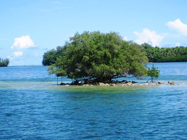
Photo courtesy of earthobserver.org
|
In March 2010, a small island in the Bay of Bengal disappeared under water. Many speculate the cause of disappearance to be several climate change-induced factors. The island first emerged in 1971 at the mouth of Hariabhanga River, because the river separated India and Bangladesh, the incidence of the island was strategically valuable, and both Bangladesh and India immediately claimed sovereignty of the island. The dispute over the small island quickly reignited and escalated a long running tension between two nations over the maritime delimitation of territorial waters and exclusive economic zone (EEZ), both are crucial for access to marine resources of the Bay of Bengal. This case study first illustrates an instance where ongoing climate change may have contributed to the complicating of an already decades-old conflict. Secondly, this study aims to address primary elements hindering the settlement of the ongoing Indo-Maritime boundary dispute, which still remains to be resolved today.
Description of the event
Indo-Bangladesh maritime border dispute
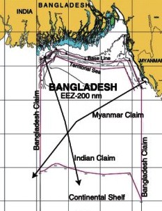 |
Figure 1: Maritime border dispute in the Bay of Bengal Source: The Daily Star, 2008 |
India and Bangladesh are closely attached in both historical and geographical contexts. Naturally, the presence of either as a neighbor has significantly affected diplomatic relations on both sides. Geologically, India and Bangladesh co-occupy approximately 180 km of maritime borderline.[1] However, due to constantly changing river courses from soil erosion and frequent floods, both nations have claimed overlapping maritime boundary.[2-4]
During the aftermath of the Bhola Cyclone in 1971, a small island unexpectedly emerged in the Ganges Delta region of the Bay of Bengal.[4] Because the island emerged approximately 3.5 km from the mouth of the Hariabhanga River, which serves as the river border between Bangladesh and India, its geological location prompted both nations to claim the island under their jurisdiction. Soon, the concern regarding sovereignty of the island reignited and escalated the long neglected border dispute between the two nations, which is today known as the Indo-Bangladesh maritime boundary dispute.[5] The disputed island was named 'New Moore' by India, and 'South Talpatti' by Bangladesh.[6]
To delimit their maritime boundary, India applies the equidistance principle and Bangladesh claims one based on equity principle.[2] This has resulted in overlapping maritime boundary between the two nations and highlights the fact that concept of maritime boundary demarcation refers not only to the settling of the outer limit of maritime zones, but also overlapping maritime zones with opposite or adjacent nations.
 |
| Figure 2: Bangladesh and India's conflicting maritime boundary claims. Bangladesh's equity principle is shown in red, while India's equidistance principle is in yellow. |
Delimitation of maritime boundary normally takes a long time, especially when there are overlapping and disputed maritime waters involved.[7] The demarcation of Indo-Bangladesh maritime boundary has been pending since 1971, and this case is ongoing as no agreement has been reached to resolve this issue. This makes a large part of the Bay of Bengal undelimited, disputed, and inexploitable.[7] There are largely three issues in this maritime boundary dispute, which will be further discussed in the next chapter.
I. The determination of the Hariabhanga River border boundary, where the ownership of the New Moore / South Talpatti Island became a center of dispute.
II. The determination of territorial water boundary up to 12 miles.
III. The determination of the EEZ boundary of a further 188 miles from the end of territorial waters (12 + 188 miles = 200 miles EEZ).
Duration
1971 - Present
Since the sudden emergence of New Moore / South Talpatti Island in 1971, India and Bangladesh have long disputed over (1) the ownership of the island, and (2) the demarcation of maritime boundary for over 40 years [2]. Although the disputed island is now submerged, the two nations have failed to reach bilateral agreement on delimitation of their maritime boundaries. In December 2011, the International Tribunal for the Law of the Sea (ITLOS) has announced that its final legal verdict will be delivered in March 2012 to settle the dispute concerning delimitation of maritime boundary in the Bay of Bengal.[8]
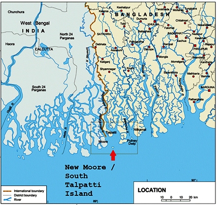 |
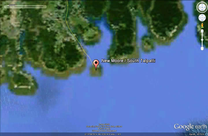
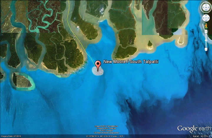
Figure 3: Location of New Moore / South Talpatti Island Source: UNEP, 20008 |
Location
The disputed island, now submerged below sea-level, was originally situated in the coastal, shallow Bay of Bengal, approximately 3.5 km south from the mouth of the Hariabhanga River (21.37. 00N, 89.12.00E) [4].
The Hariabhanga River, which serves as the disputed Indo-Bangladesh maritime border (21.37.00N, 89.08.30E), flows between Satkhira district of Bangladesh and the South 24 Parganas district of West Bengal, India.[9, 10]
The river mouth debouches into the Bay of Bengal, which lies at the mouth of the Bengal Delta.
Little more background...(actors and some concepts)
Bangladesh and India
Both Bangladesh and India are part of the Indian subcontinent, and have long shared many cultural, economic and political values. Bangladesh gained independence from India through the Liberation War, which ended in 1971. The diplomatic relationship between the two countries since then has gone through a series of turmoil.[6]
Bangladesh is a densely populated, but resource-poor country. Naturally, the nation strives to make the most of whatever resources it can lay claim to within its geographical boundary. For example, fisheries in the region are the source of income for approximately 14 million fishers. And roughly two-thirds of Bangladesh and one-fifth of India's national protein supply is provided by fisheries.[10]
Although Bangladesh is entitled to 12 nautical miles of territorial sea and 200 nautical miles of EEZ, its proposed maritime boundaries are overlapped and counterclaimed as Bangladesh is being sandwiched by India and Myanmar. This leaves Bangladesh's territorial waters still undemarcated today.[2]
India acknowledges the value of the Bay of Bengal in the Ganges Delta region fueled by both Hariabhanga and Raymangal Rivers, and has claimed its maritime boundary and sovereignty in the Bay of Bengal through the presence of its naval force. India has expressed its interest to apply any means necessary to assert its sovereignty of the island.[11]
Basic concepts of maritime boundary
 |
Figure 4: Maritime boundary of New Zealand. Source: National Institute of Water and Atmospheric Research, 2011 |
In principle, maritime boundary can be described as a legal tool to divide the earth's water surface into maritime areas based on physical or political geography. Maritime boundaries are established through international conventions, and define areas of exclusive national rights over the mineral and biological resources.[12]
A nation's maritime boundary normally encompasses territorial waters, contiguous zones, and exclusive economic zones, and is recognized by the United Nation Convention on the Law of the Sea. Although rivers and lakes are usually included within land boundaries, both geophysical features often serve as maritime boundaries.[12]
By international law, a coastal nation may claim 12 nautical miles of territorial sea, and 200 hundred nautical miles of exclusive economic zone. A geological concept of continental shelf refers to the continental margin from shoreline to the point where the depth of the water reaches approximately 200 m. Continental shelf may also serve as the underwater prolongation of the land territory for coastal states. The continental margin may include seabed, subsoil of the shelf, but does not include the deep ocean floor where large deposits of natural resources are often discovered.[12, 13]
Because the delineation of maritime boundaries normally addresses strategic, economic and environmental implications, some of the maritime boundaries are overlapped, disputed, and remain undemarcated. Conflicts over maritime boundaries typically address two aspects: (1) a territorial or historical sovereignty; and (2) jurisdictional rights and interests in maritime boundaries. The latter aspect often stems from different understanding of the Law of the Sea.[13]
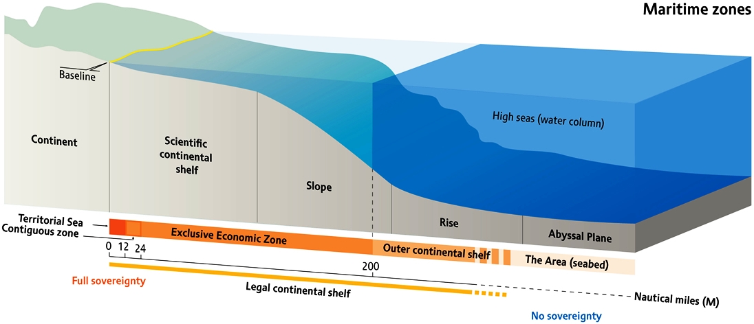 |
Figure 5: Graphic representation of maritime zones Source: Riccardo Pravettoni, UNEP/GRID-Arendal, 2009 |
For the settlement of maritime boundary delimitation disputes, states may select more than one of the following methods under Part XV of UNCLOS.[2]
International Tribunal for the Law of the Sea (ITLOS)
International Court of Justice (ICJ)
An arbitral tribunal constituted in accordance with Annex VII
Deep water hydrocarbon reservoirs in the Bay of Bengal
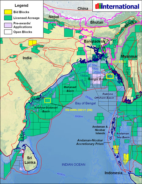 |
Figure 6: The major sedimentary basins and current blocks under lease in the Bay of Bengal for oil exploitation. Noice Bangladesh does not own many licenced acreage. Source: DIInternational, 2008 |
Although the average depth area around the island is 3 - 5.5 m, the average depth of continental shelf surrounding the Bay of Bengal can stretch up to 10 km to form the deep oceanic creek approximately 43 km south of the island. The Bay of Bengal has long believed to be rich in deep-water deposits of oil and natural gas.[3, 14]
India has recently discovered roughly 100 trillion cubic feet of hydrocarbon deposit in the deep oceanic creek, which was followed by Myanmar's discovery of another 7 trillion cubic feet of hydrocarbon deposit. These recent discoveries of large natural gas deposits have further escalated the significance of the delimitation of maritime borders.[3]
India and Bangladesh's growing demand for energy has led to offshore operation and allocation of maritime blocks for further exploitation of resources. This has also generated further tension as Bangladesh filed a complaint against India's exploitation in 2006 while India counter-opposed Bangladesh in 2008. There were also two military tensions in 2008 and 2009 between Bangladesh and Myanmar over the disputed maritime boundary.[5]
While the boundary dispute remains unresolved, India declared its offshore blocks for the deep-sea natural resources, which once again overlaps with Bangladesh's claimed EEZ. Although both sides temporarily agreed to cease any exploitation within the overlapping blocks, the maritime borderline dispute remains unsettled.[14]
Type of Habitat - tropical, ocean
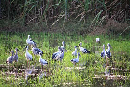 |
Figure 7: Asian openbills in Ganges Delta during wet season Photo courtesy of Michel19481 http://www.panoramio.com/photo/16940058 |
The area around the Hariabhanga River is known as the Ganges Delta, and features several geophysical conditions such as tidal floodplains, bogs, wetlands, shoals formed by river deposits, and river borne clayey lowlands.[9] Closely tied with the Bay of Bengal, the Ganges Delta is the world's largest delta, and is one of the most fertile regions included in reference to the Green Delta.[4]
The Ganges Delta possesses river-eroded continental coast in the east, and sand beaches in the southeast. This combination makes the entire region extremely vulnerable to the seasonal flood, cyclone, storm, high salinity, tidal bores, and river bank erosion.[3, 4] These natural phenomenon have played significant roles in both geophysical processes of land erosion and sedimentation of the New Moore / South Talpatti Island, and the climate change and ongoing sea-level rise are likely to aggregate the current state of environmental problems.
The Ganges Delta is under tropical wet climate, and receives approximately 1,500-2,000 mm of annual rainfall in its western part, and roughly 2,000-3,000 mm in the eastern side. January is usually the coolest month (14-25 C), while April, May, June are the warmest months on average (25-35 C). July is the begging of monsoon season and the delta receives over 330 mm of rainfalls on average.[15] IPCC confirmed the atmospheric temperature in the Bay of Bengal has risen at 0.4 C per year, and sea-level has risen at a rate of 5 mm per year in period of 2000-2009. And with an estimated 1 m sea-level rise by 2050, 17% of Bangladesh will be submerged.[16]
The Sundarbans, Palk Bay, Gulf of Mannar, Andaman Marine National Park, and Maldives Atolls are some of the areas with critical biodiversity in the region.[17] The Sundarbans, which covers over 12,000 km2, is known as the most economically valuable natural wildlife habitat shared by Bangladesh and India.[17]
Although the Ganges Delta has experienced aggravated habitat modification as a whole, the rate of modification of Bangladesh and India's natural habitats is considered to be moderate.[18] However, because the region is geographically closed in the north by high mountains, migration of endemic species to higher latitudes is disturbed. It is likely that climate change will leave severe impacts on the region's biodiversity in future.[17]
A study has shown that promotion of brackish water shrimp farming and poor coastal property management have damaged mangrove forests and associated coastal ecosystems in the last few decades.[18] Most of the mangrove forests in the region are extensively degraded or under growing human pressures. Over the last 100 years, the Sundarbans in Bangladesh has lost more than 150,000 ha of mangrove forest due to agriculture and industrial activities.[19] Coral reefs in the region have also been damaged through several bleaching events, largely due to increase in sea-surface temperature.
Type of Environmental Problem
While the impact from climate change is considered to be severe in the region, majority of other ongoing environmental degradations are also led by human activities. Land-based pollution, such as sewage, agriculture / aquaculture run-offs, and industries have become major threats to the region's environment. Many of those pollution are also trans-boundary, and can travel across the region through the atmosphere and international rivers.[9]
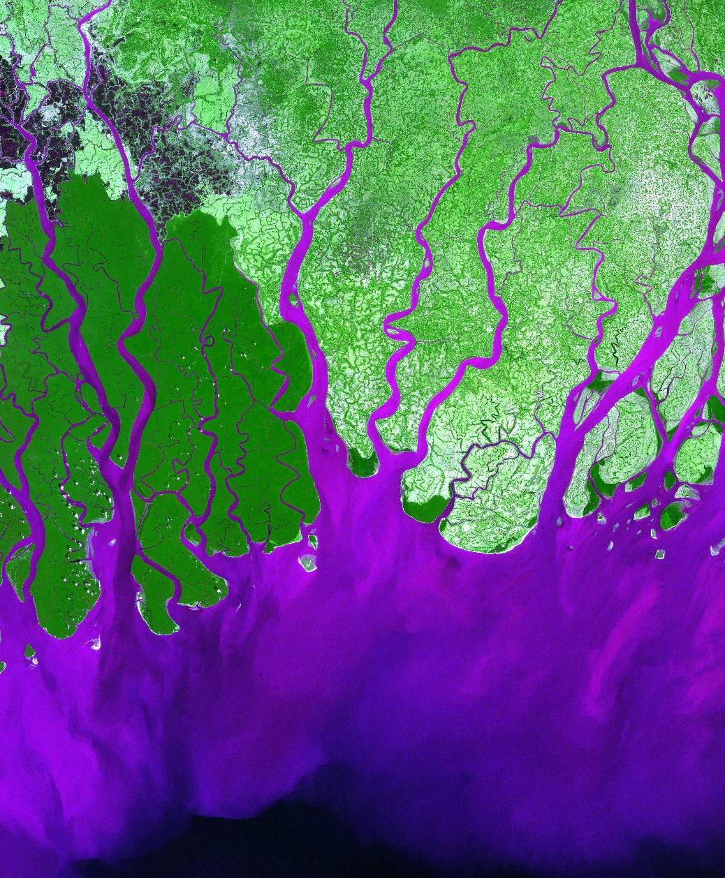 |
Figure 8: False-color satellite image of inland sedimentation in Ganges Delta. Source: USGS, 2010 |
The region's Ganges-Brahmaputra-Meghna river system is a major recipient and transporter of waste from industries in Bangladesh and India. As a consequence, the Bay of Bengal suffers from high amounts of organic and inorganic nutrient input. Many studies have suggested the strong correlation between nutrient enrichment and frequencies of eutrophication, hypoxia, and algal blooms. India has experienced an increase in both frequency and persistence of harmful algal blooms over the past 30 years.[20]
Among many pollutants, sewage has been identified as a major priority issue. Household nutrients and chemicals, POPs, contaminated wastes from medical and industrial activities are known to be the major sources of sewage. The region's heavy reliance on agriculture and aquaculture has promoted the wide usage of pesticides and other chemicals which further multiply the problem.[9, 20]
Environmental degradation caused by inland sedimentation is common in the region, including the Andaman Sea. Deforestation caused by agriculture, aquaculture, and urban development is the major cause of sediment mobilization.[21] The river system in the Ganges Delta region delivers approximately 30% of the world's total load of river sediment. Heavy inland sedimentation often causes high turbidity in the coastal water, which can even be observed by satellites.[9]
Sea-based pollution's caused by oil exploration and production are also major threats to the region's ecosystem and biodiversity. Because the region serves as a gate to enter the Straits of Malacca, the Bay of Bengal experiences heavy traffic from oil tankers frequenting the route between Japan and the Middle East. Its marine environment suffers from chronic oil pollution and waste discharges from many ships. A growing emphasis on offshore oil exploration will further deteriorate the current oil pollution.[22]
Other environmental issues include fresh water scarcity, soil degradation, sedimentation and siltation, reclamation, overgrazing, deforestation, desertification, water-borne diseases, illegal fishing, and overpopulation.[17]
Disputes over maritime boundaries
The long-pending maritime border dispute has principally evolved upon: (a) sovereignty of the small island middle of their river boundary, and (b) conflicting territorial waters and overlapping EEZ boundary in the Bay of Bengal.
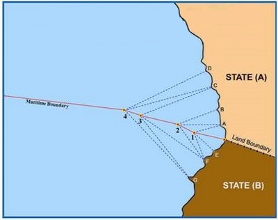 |
Figure 9: Maritime boundary between adjacent two countries based on Equidistance principle. Source: Dallmeyer, D., et al., 1989 |
The year 1974 can be marked as the first session of official negotiation held in Dhaka.[6] After unsuccessful negotiation between foreign secretaries, the case was submitted to the dialogue between foreign ministers in 1975.[23] Official talks were held in 1974, 1975, 1978, 1980, and 1982, but marked no progress and inconclusive results each time.[6]
In 2008, India and Bangladesh held much anticipated maritime boundary discussions, which remained once again inconclusive as both parties maintained their earlier claims.[24]
The UNCLOS's proposal to apply the equidistance principal for the purpose of maritime boundary demarcation is supported by India, but rejected by Bangladesh due to the magnitude of the associated loss.[2]
Principal issues
First: A dispute over the New Moore / South Talpatti Island
There are several fundamental disagreements among India and Bangladesh over the methods of delimitating their marine boundaries. The first dispute stems from the issue regarding the ownership of a small island in the Bay of Bengal.
During the aftermath of the Bhola Cyclone in 1971, a small island unexpectedly emerged in the Ganges Delta region of the Bay of Bengal. Because the island emerged approximately 3.5 km from the mouth of the Hariabhanga River, which serves as the river border between Bangladesh and India, its geological location prompted both nations to claim the island under their jurisdiction. Soon, the concern regarding sovereignty of the island became a major reason of dispute between India and Bangladesh. The disputed island was named 'New Moore' by India, and 'South Talpatti' by Bangladesh.[25, 26]
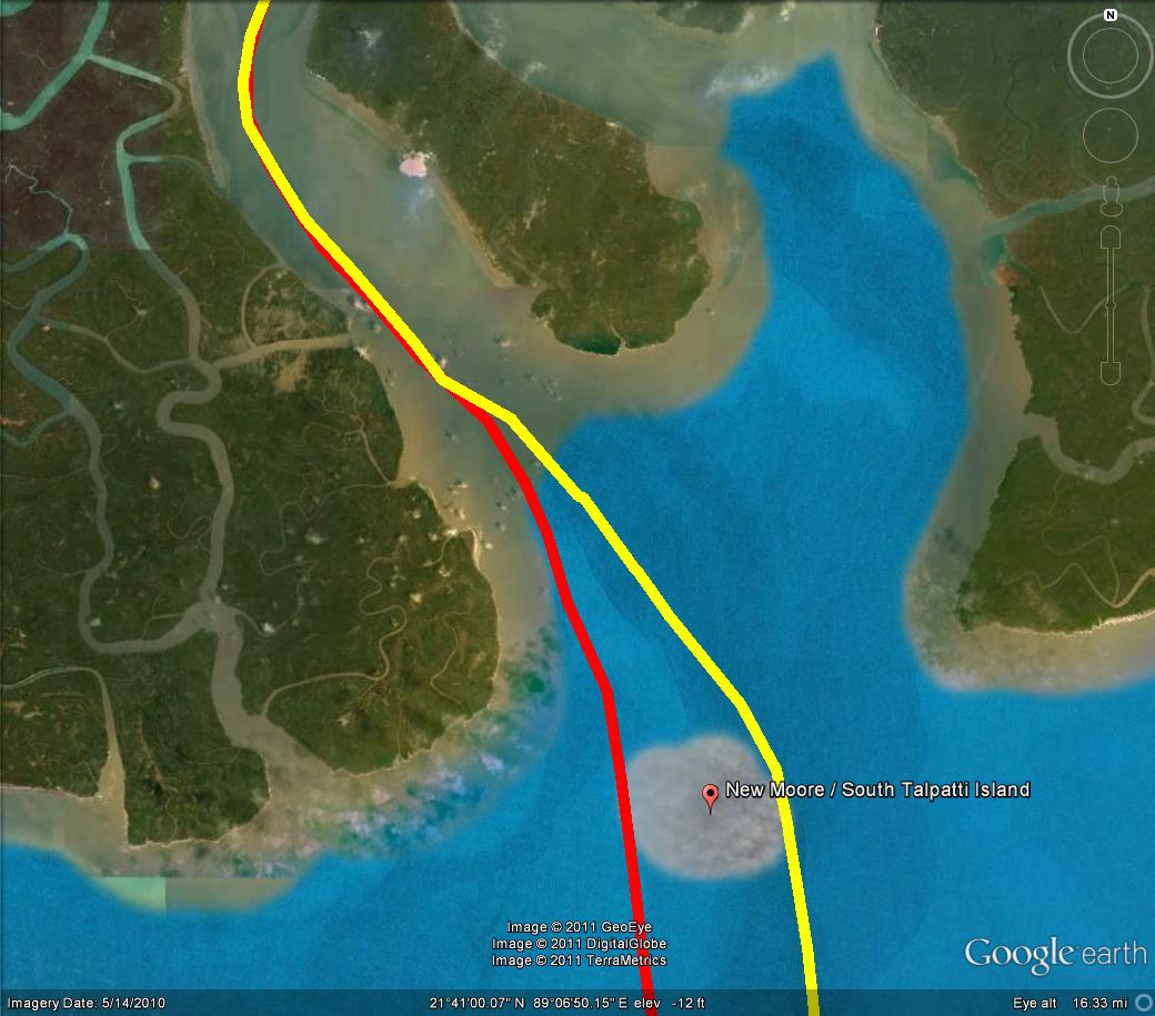 |
Figure 10: India (yellow) and Bangladesh (red)'s attempt to define the deepest navigable channel of the Hariabhanga River. |
According to the Thalweg doctrine, when a river separates two nations, the middle of the deepest navigable channel serves as the borderline. Because of this doctrine, the river flow around the island became the subject of maritime border dispute.[13, 26] Therefore, if the river's main channel flowed towards the west of the island, the island would belong to Bangladesh, and if the flow was towards the east, the island would be India's.[26]
India claimed that the mid-flow was clearly on the eastern side of the island thus claiming its ownership. On the other hand, High-ranking Bangladesh Foreign Ministry officials claimed that satellite photographs show the main river channel flowing on the western side of the island, thus registering the island in their administrative documents. Bangladesh proposed a joint survey to determine the exact position of navigable main deep-water channel, but India rejected Bangladesh's proposal and hoisted its national flag on the island in response.[23]
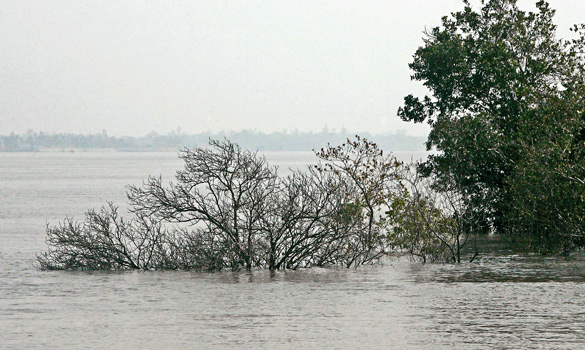 |
Figure 11: Last known photograph of New Moore / South Talpatti island, taken in 2009
|
The island was approximately 3.5 km at the north-south length and 3km wide across east-west. Upon emerging, the island had roughly 2.5 sq km, but its area fluctuated between 7 sq km to 14 sq km due to changing tide. The island was the result of alluvium deposits transported by distributaries of the Ganges-Padma River system, and was approximately 2 m above sea-level at its highest point. Shallow lagoons surrounded the island with the gradual lowering to the Bay of Bengal.[27]
Change in the environment due to ongoing climate change added further complications. The island began showing signs of shrinking in the 1990s, and in March 2010, disappearance of the island was confirmed by the School of Oceanographic Studies at Jadavpur University, sea patrols, and satellite imagery.[28] Although the mechanism of the inundation of island is unknown, sea-level rise caused by climate change is believed to be a significant factor alongside changes in monsoonal rain patterns, altered river flows, and land subsidence. Studies have also confirmed an accelerated pace of erosion in other small islands in the region. The most recent satellite images show scattered and submerged shoals on the north and southeast side of the island near the Haribhanga estuary and vast submerged landmass in the shallow seawaters around the island.
 |
 |
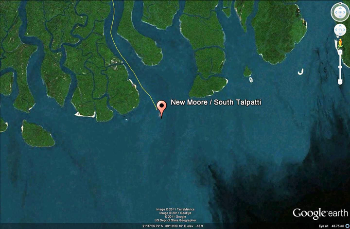 |
Figure 11: Satellite Images of the New Moore/South Talpatti Island in chronological order (from top left in clockwise direction 2000, 2010, 2011) |
Second: The determination of territorial water boundary
The second disagreement stems from the definition of 'territorial waters'. Territorial waters are normally referred as a belt of coastal waters extending up to 12 nautical miles (22 km) from the 'baseline' of a coastal state.[13] Although there are several different contexts to define a nation's baseline, normally the baseline is explained as a line connecting low-water marks closest to its shore.[29]
The concept of territorial waters was first defined by United Nations Convention on the Law of the Sea (UNCLOS) in 1982.[13] Under the treaty, any coastal states are given full sovereignty within their territorial sea, which may extend up to 12 nautical miles of its baseline. While foreign vessels (both military and civilian) are to enter through innocent passage, the state may retain full sovereignty for the airspace over and seabed below.[12]
India supports the traditional concept that a nation's baseline should be drawn based on low-water marks.[24] This law-water baseline concept creates a baseline that closely follows the curves of vertical coastline to establish 12 nautical territorial waters (figure 2). India's 12 nautical miles boundary also includes Andaman, Nicobar and Lakshadweep, and India insists that Bangladesh comply with a same low-water baseline concept.
 |
| Figure 12: India's 'low-water' baseline (red), and Bangladesh's 'low-water' baseline perceived by India (orange) |
On the other hand, Bangladesh has a very uneven and unstable coastline with so many rivers merging with the Bay of Bengal. Therefore, in 1974, Bangladesh claimed there was a tremendous difficulty to follow the concept of low-water baseline, and strongly endorsed a system of straight baseline.[30]
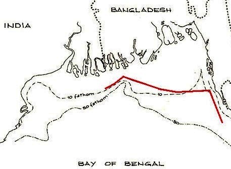 |
Figure 13: Bangladesh's straight line system. Source:http://www.un.org |
Under the UNCLOS Article 7, straight baseline is defined as applicable method where 'the presence of a delta and other natural conditions the coastline is highly unstable, and the appropriate points may be selected along the furthest seaward extent of the low-water line, and, notwithstanding subsequent regression of the low-water line. This implies that a straight baseline as an alternative baseline for territorial waters, and can be applied when a region is characterized with a fringe of islands, or deeply indented and unstable coastlines. Based on the straight baseline concept, a baseline anchors geographical landmarks such as islands and shallow water grounds (figure 3).[30]
| POINT | LATITUDE NORTH | LONGITUDE EAST |
| No. 1 | 21.12' 00" N. | 89.06' 45" E. |
| No. 2 | 21.15' 00" N. | 89.16' 00" E. |
| No. 3 | 21.29' 00" N. | 89.36' 00" E. |
| No. 4 | 21.21' 00" N. | 89.55' 00" E. |
| No. 5 | 21.11' 00" N. | 90.33' 00" E. |
| No. 6 | 21.07' 30" N. | 91.06' 00" E. |
| No. 7 | 21.10' 00" N. | 91.56' 00" E. |
| No. 8 | 20.21' 45" N. | 92.17' 30" E. |
Bangladesh's proposed straight baseline concept is based on depth criteria, the eight base points following a 10 fathom line. However, Bangladesh's straight baseline system is controversial and has been strongly opposed by its neighbors and other nations in the world.[30] The US, for instance, protested the Bangladesh's claim in 1978 and conducted operational assertions in 1995, 1996, 1998, and 2000.[5]
 |
| Figure 14: Bangladesh's 'straight baseline' based on low water grounds and islands (green) |
Third: The settlement of EEZ
The third disagreement is related to which direction should maritime borderline to be drawn to establish the maritime zones in the Bay of Bengal. As briefly described in previous chapter, to delineate maritime EEZ boundary, India has applied the Equidistance principle from its respective coastline at the eastern shore of the Bay of Bengal.[31]
The principle of equidistance defines a nation's maritime boundaries should follow a median line that is 'equidistant' from the nearest points of the baselines from which the breadth of the territorial sea of each of the two States is measured.'[29] Thus, the methodology of equidistance is often applied where the border of adjacent nations was located on a contiguous coastline. This concept of equidistance is endorsed and referred by the UNCLOS.[32] However, because the bay is somewhat triangular in shape, India's demarcation only causes deprivation of marine resource to Bangladesh. As Myanmar also employs the equidistance principle to establish its maritime boundary, Bangladesh becomes the 'zone-locked' country in the Bay of Bengal.[26]
 |
| Figure 15: Above - India (orange) and Myanmar (yellow) maritime border claims and zone-locked Bangladesh. |
On the other hand, as Bangladesh strives for justifiable share of marine resources and high-sea territory, based on the straight baseline principle, the nation has applied the equitable principle based on the straight baseline to delineate the most of its maritime boundaries.[26]
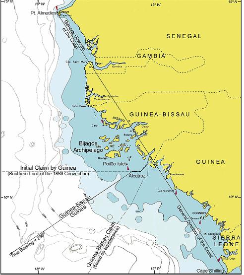 |
Figure 16: 1983 Guinea/Guinea-Bissau arbitration. Notice initial claim made by Guinea-Bissau is based on equitable principles. Source: Antunes, N. 2003 |
As the name implies, the equitable principle employed by Bangladesh emphasizes equity in its nature. The methodology of equitable principle is designed to produce an equitable solution to overlapping boundary claims rather than following conventional methods of delimitation.
Contrary to the equidistance principle, application of equitable principle takes extenuating circumstances into account when the strict application of conventional equidistance principle would lead to unduly harsh or unjust outcomes. Normally, a boundary based on equity is result of all equitable variables available in the delimitation area combined, then balanced to evaluate the relative weight of each factor.[33]
The case of 1969 North Sea Continental Shelf is often referred as a notable instance where the ICJ rather emphasized the equitable approach on delimitation over the conventional equidistance line. The 1983 Guinea/Guinea-Bissau arbitration is another instance where the use of the equidistance line was proposed by Guinea-Bissau.[33]
Application of equitable principle often results in controversial outcome as its standard can be vague and subjective. The equitable maritime zone proposed by Bangladesh is no exception as its boundary overlap with India and Myanmar's maritime zones, which are both recognized by the UN.
 |
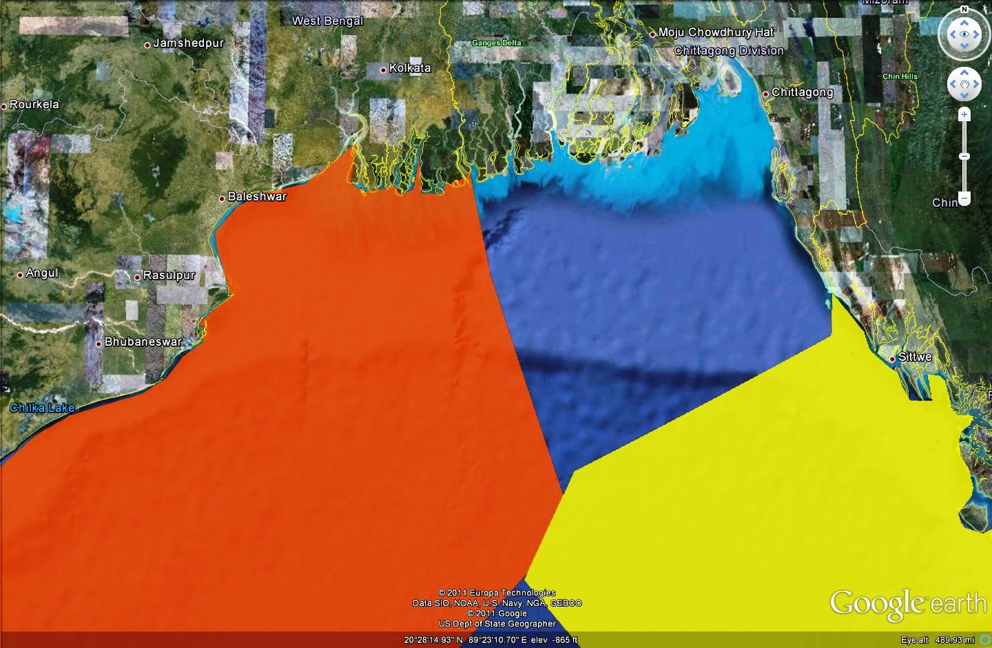
| Figure 17: Above - India (orange) and Myanmar (yellow) maritime border claims and zone-locked Bangladesh. Below - Bangladesh's maritime border claim (green) |
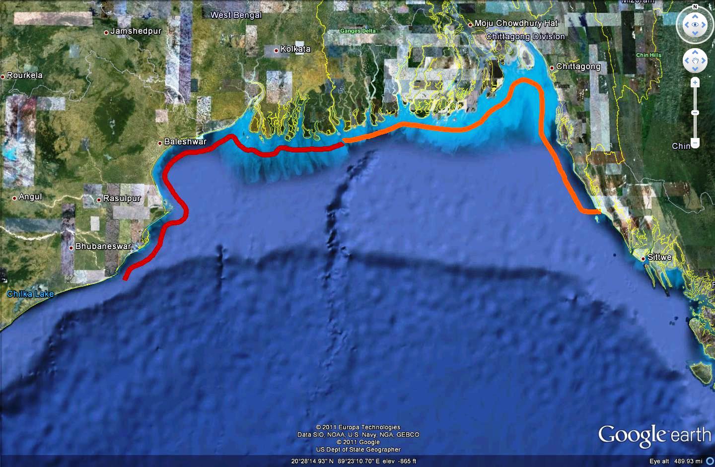
Fourth: Maritime boundaries in a rising sea
The submerged island, territorial waters, and overlapping maritime boundaries are not the only concerns in this dispute. India and Bangladesh's highly indented and unstable coasts around the Bay of Bengal are known for their vulnerability against projected sea-level rise.[4] For example, a sea-level rise of 1.5 m would dramatically affect the outcome of current maritime border dispute as the Sundarbans coastline in the Bay of Bengal will be submerged and reshaped radically.[4] Such geographical modification would considerably change the current layout of EEZ boundaries based on the equidistance principle, that India and Bangladesh are entitled under UNCLOS.
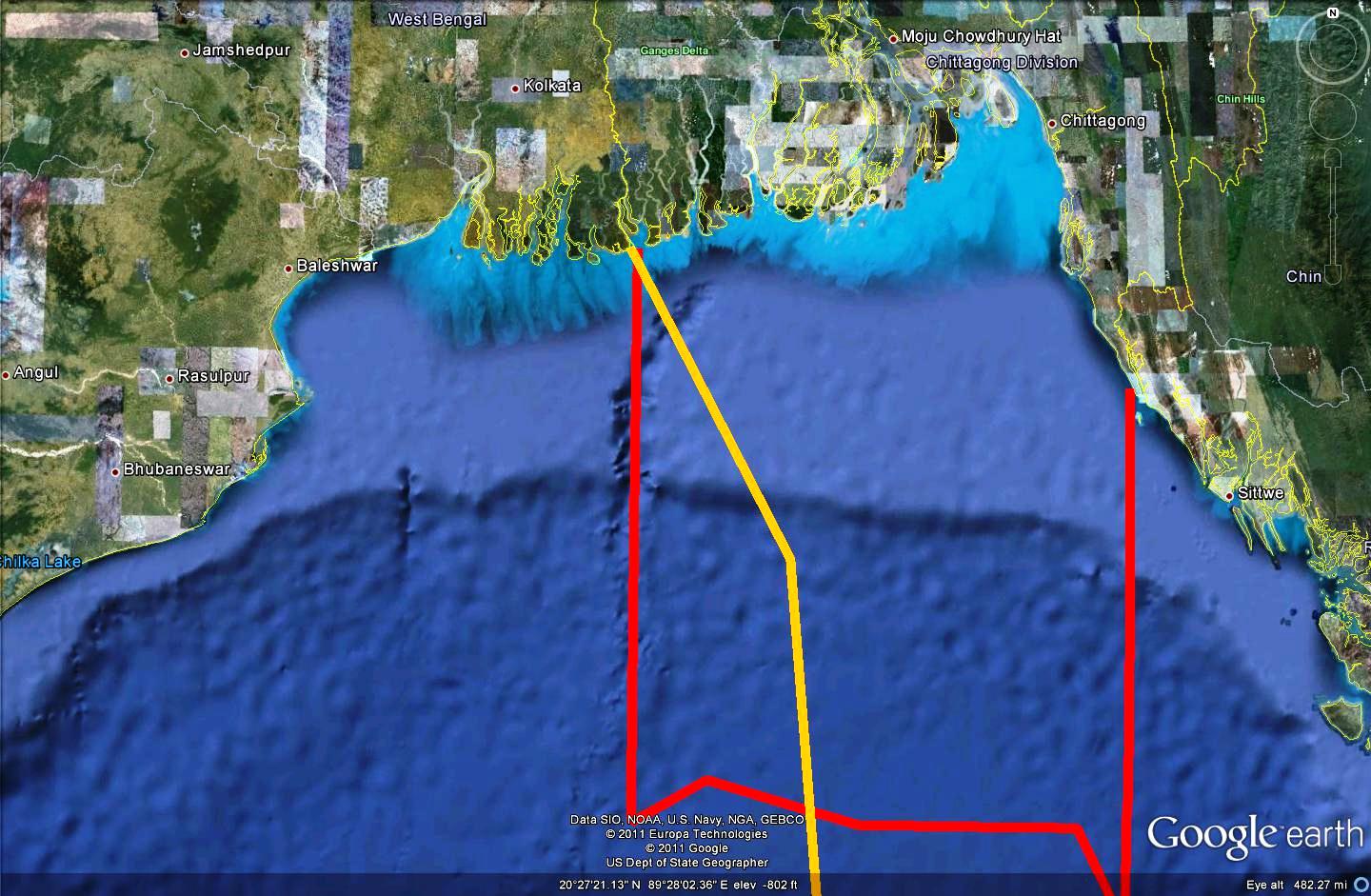
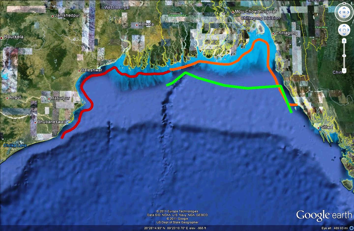
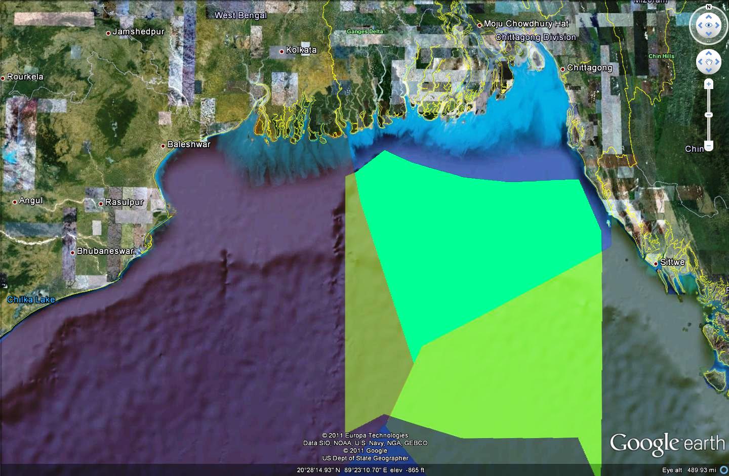
The figure below shows the potential consequences under the scenario of a 1.5 m sea-level rise in the Bay of Bengal. The area marked with orange color indicates the land below 1.5 elevations. While green lines show the respective countries' current claims for their EEZ based on the equidistance principle, red lines indicate potential EEZ claims after sea-level rise. This projection suggests that as India's coastline retreat as a result of sea-level rise, Bangladesh's maritime zones will expand, especially if the nation's disputed straight baseline is not found violating international law. While nearly two-fifth of Bangladesh will be submerged, this unexpected expansion of maritime zone though sea-level rise would improve Bangladesh's accessibility to oil and gas reserves in the Bay of Bengal.[34]
Alternatively, India (and Myanmar) can maximize their EEZ maritime zones by pursuing a demarcation that fulfills the following conditions; (1) denunciation of Bangladesh's straight baseline, (2) the respective low-water lines as the territorial water boundaries, and (3) the present equidistance lines serves as the outer limits of the corresponding EEZ. Counter- intuitively, equidistant coordinates calculated using straight baseline fixed without accommodating progressive sea-level rise may in fact be more advantageous for Bangladesh.[34]
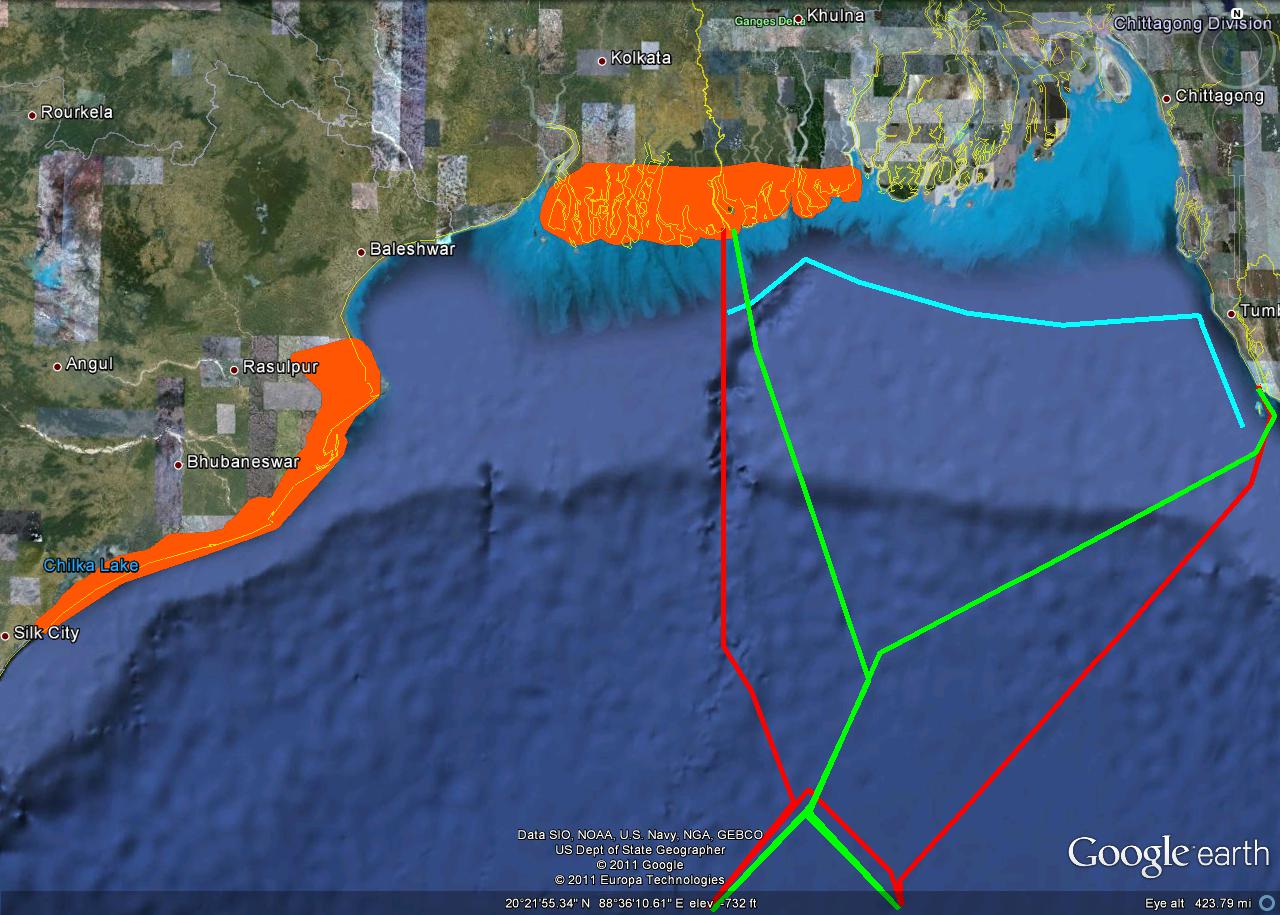 |
| Figure 18: EEZ maritime boundaries median line 2009 (Green line); EEZ boundaries at 1.5m sea-level rise (red); Area below 1.5m elevation are shown in orange color. |
Level of Conflict
- resource access
- natural change in environment
- political / border
When India noticed the tip of the newly emerged island in late 1971, India immediately reported the island to the British Admiralty to officially place the island on the admiralty chart as New Moore Island.[23] As the formation of the island was confirmed by satellite in 1975, Indian Border Security Force installed concrete pillars and built a billboard representing the Indian flag and map on the island in 1978.[31]
Two years later, complying with orders from the Indian government, the West Bengal government raised a national flag of India in March 1980.[23] This apparent Indian occupation of the island aggravated the Indo-Bangladesh relations, and formed an intense anti-Indian public opinion in Bangladesh. A series of large anti-Indian demonstrations were held and the office of Indian Airlines was damaged by a crowd,when Indian Foreign Minister Narashima Rao visited Dacca in August 1980.[6, 23]
Bangladesh made several proposals to conduct a joint survey to determine the sovereignty of the disputed island. However, India rejected every joint survey proposal, and then Indian foreign minister issued a written statement on July 15, 1980 to announce the island was situated well within Indian territorial waters. India repeatedly emphasized the ownership of the island was conclusively proven by available scientific data, thus found no justification for conducting a joint survey of the island.[6]
Bangladesh immediately issued a complaint that India had made commitments at the highest level to a joint survey, which should therefore be honored. This complaint was once again turned down by India. Some efforts were made to settle the New Moore/South Talpatti dispute peacefully after Narashima Rao'svisit to Dacca, New Delhi. However, the Indo-Bangladesh Joint Statement issued following the visit failed to mention a specific method of settlement.[23]
The situation was further aggravated on May 9, 1981, when Indian naval fleets entered the vicinity of the island to physically occupy the island by landing troops. India defended its aggressive military activities as being a response to the provocative activities by the Bangladesh Navy patrol boats around the island. Bangladesh issued a strong worded protest that its navy forces remained within territorial water of Bangladesh throughout the period, and demanded the immediate withdrawal of military force off the island.[6, 23]
Fatality Level of Dispute
- low level of Military and civilian fatalities
In reactions of the initial Indian occupation of the island, Bangladesh political parties and the Secretary General strongly criticized the Indian action. There were also protest rallies and meetings organized by Bangladesh political parties in front of the Indian High Commission office in Dacca, demanding an immediate withdrawal of the Indian force off the island. In response, India rejected all Bangladeshi protesters demands and remained its military infrastructure on the island. The then Bangladesh government led by Khaleda Zia drew strong criticisms from opposition parties for giving up on the island.[23]
Environment-Conflict Link and Dynamics
- indirect
Causal Diagram
- climate change, the island, and Indo-Bangladesh relation
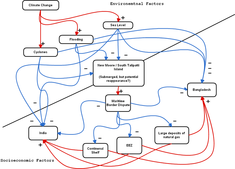
This causal diagram above shows the impact that climate change may potentially have on the Bay of the Bengal Mekong Delta in future.
Notes on diagram
Variables are largely divided into two categories; environmental and socio-economical. The color of line in the causal diagram will show whether the variable can be positive (red) or negative (blue) impact in nature for the relationships. The diagram also shows the overall system state as exponential as there is no feedback mechanism.
Level of Strategic Interest
- region
It remains to be determined if resolution of the maritime border dispute is an apt solution to rectify ongoing detrimental impacts from climate change. However, the deep-water resources, maritime claims based on contentious mixtures, and all other variables are likely to further complicate above mentioned diagram and will be ever more difficult to resolve legally.
Outcome of Dispute
- in progress (a verdict by the UN expected in March 2012)
Annex VIII Arbitration: India and Bangladesh
This highly complicated dispute between Bangladesh and India is currently being examined by the International Tribunal for the Law of the Sea (ITLOS), an independent body under the UNCLOS and primary judicial organ of the United Nation.[34]
On October 8, 2009, to delimitate its maritime boundary in the Bay of Bengal, Bangladesh finally submitted its written pleadings to the ITLOS. As the UN Framework on Climate Change acknowledges the needs and special circumstances for countries vulnerable to climate change, the principle of equity anchored in Article 74 (1) was repeatedly emphasized over a strict application of equidistance principle during the process of arbitration. However, despite commencement of an arbitration process by the ITLOS, no bilateral agreement has yet to be achieved in 2011.[35]
On December 6, 2011, at the UN General Assembly, a newly elected president of ITLOS Shunji Yanai described the arbitration process by ITLOS has taken a €œreasonable duration for a maritime delimitation case €, and announced that ITLOS will deliver its much anticipated legal verdict on this dispute in March 2012. Both Bangladesh and India anticipate the outcome of final demarcation of their maritime boundaries.[36] The outcome this case will be crucial for future maritime boundary dispute, especially in regards to the adaptation of non-conventional demarcation of disputed maritime boundaries.
Related Information and Sources
Related ICE and TED Cases
Climate Change & The Expansion of Canada's Continental Shelf
by Alicia Marrs
Disputing the Continental Shelf Region in the Aegean Sea: The Environmental Implications of the The Greek - Turkish Standoff
by Chip Arvantides
India-Bangladesh Water Dispute
by Robie I. Samanta Roy
Climate Change Induced Extreme Weather Events & Sea Level Rise in Bangladesh leading to Migration and Conflict
by William Alex Litchfield
Arunachal Pradesh Territorial Dispute between India and China
by Yuki Kawaguchi
Peru Ecuador Border Dispute
by Jeffrey Franco
Korea - Japan Fish Dispute
by Kunwoo Kim
Nicaragua-Honduras Territorial Dispute
by Rebecca A. De Mar
Relevant Web sites and Literature
[December 19 2011]